Let’s delve into the crucial types of minimum IFR altitudes vital for your next flight.
1. Minimum En Route Altitude (MEA)
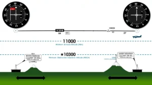
MEA is the lowest published altitude between radio fixes, ensuring navigation signal coverage and obstacle clearance.
2. Minimum Reception Altitude (MRA)
FAA flight inspection determines MRAs by traversing an entire route of flight, establishing the minimum altitude for receiving navigation signals along the route and off-course NAVAID facilities.
When the MRA exceeds the MEA at the fix, it’s set as the lowest altitude to determine an intersection.
3. RNAV Minimum En Route Altitude
RNAV MEAs are featured on specific IFR en route low altitude charts, allowing both RNAV and non-RNAV pilots to use the same chart for instrument navigation.
4. Minimum Obstruction Clearance Altitude (MOCA)
MOCA, the lowest published altitude between fixes on VOR airways, off-airway routes, or route segments, guarantees obstacle clearance for the entire route segment.
This altitude ensures there’s enough navigational signal coverage within a 22 NM radius of a VOR.
5. Maximum Authorized Altitude (MAA)
MAA indicates the maximum usable altitude or flight level for an airspace structure or route segment.
It’s the highest altitude for Federal airways, jet routes, RNAV low or high routes, or other direct routes where an MEA is designated, ensuring reliable navigation signal reception.
6. Minimum Turning Altitude (MTA)
Minimum Turning Altitude (MTA) is a specific altitude on charts that ensures you’ve got enough space vertically and laterally when you’re making turns at certain spots. For more details, you can check out Page 2-38 in Chapter 2 of the FAA’s Instrument Procedures Handbook.
The MTA helps with obstacle clearance when you’re turning before or after a fix while staying on the airway centerline. A bunch of things like aircraft speed, distance from NAVAIDs, and flight path affect how the turning area is set up to keep pilots safe.
7. Off-Route Obstruction Clearance Altitude (OROCA)
Off-Route Obstruction Clearance Altitude (OROCA) is an altitude off the regular flight path that gives clearance from obstacles. It’s got a 1,000-foot buffer in normal areas and 2,000 feet in mountainous ones. But, it doesn’t guarantee signal coverage from ground-based NAVAIDs, ATC radar, or communications.
8. Minimum IFR Altitude (MIA)
Minimum IFR Altitude (MIA) is all laid out in 14 CFR Part 91 and shown on aeronautical charts. It’s also prescribed in 14 CFR Part 95 for airways and routes, and in 14 CFR Part 97 for standard instrument approach procedures.
9. Minimum Crossing Altitude (MCA)
Minimum Crossing Altitude (MCA) is the lowest altitude at certain points where you’ve gotta cross when you’re heading for a higher minimum en route IFR altitude.
10. Minimum Vectoring Altitudes (MVA)
Minimum Vectoring Altitudes (MVA) are set up for radar use by ATC. They give 1,000 feet of space above the highest obstacle in regular areas and 2,000 feet in mountainous regions.
Sometimes, MVAs might be lower than other minimum altitudes shown on charts because they’re specifically designed to avoid certain obstacles. During radar vectoring, ATC usually assigns IFR altitudes at or above the MVA.
