
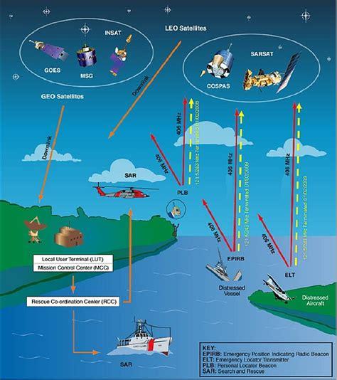
COSPAS-SARSAT is a satellite-based monitoring system designed to detect and locate emergency beacons. When a beacon is activated, professional operators quickly notify search-and-rescue (SAR) authorities. These beacons follow internationally recognized standards for radio communication and identification of their owners.
COSPAS stands for the Russian phrase “Cosmicheskaya Sistema Poiska Avariynyh Sudov,” which means “Space System for the Search of Vessels in Distress.” SARSAT, on the other hand, stands for Search And Rescue Satellite-Aided Tracking. The entire system comprises several key components:
-
Emergency beacons that send out distress signals.
-
Satellites that detect these signals.
-
Ground receiving stations that process satellite signals to generate alerts.
-
Mission Control Centers (MCCs) that receive alerts and relay them to SAR teams.
The emergency beacons currently supported by COSPAS-SARSAT operate at 406 MHz, as processing of 121.5/243 MHz signals ended on February 1, 2009. These beacons can be used by different groups:
-
Aircraft: Known as Emergency Locator Transmitters (ELTs) in aviation.
-
Ships: Referred to as Emergency Position-Indicating Radiobeacon Stations (EPIRBs) or Ship Security Alert System (SSAS) in maritime contexts, with the latter enhancing maritime security.
-
People: Commonly utilized by hikers and individuals in remote areas, these are called Personal Locator Beacons (PLBs).
COSPAS-SARSAT relies on two types of satellite constellations. The first is the geostationary orbiting search and rescue (GEOSAR) constellation, which includes SAR instruments aboard four satellites that orbit Earth at an altitude of 36,000 km over the equator. They maintain a fixed position relative to the Earth, providing coverage for about one-third of the globe, excluding polar regions. GEOSAR satellites, spaced evenly in longitude, ensure continuous coverage between approximately 70 degrees north and 70 degrees south latitude. This system’s main advantage is its ability to alert almost immediately due to its extensive coverage.
The second type is the low earth orbit search and rescue (LEOSAR) system. It consists of four satellites in a near polar orbit, completing an orbit approximately every 120 minutes. LEOSAR complements GEOSAR by offering excellent coverage of polar regions and accurately calculating the location of distress signals using Doppler processing techniques. Additionally, it is less prone to obstructions that might block a signal since the satellite is always moving relative to the beacon.
In 2004, development began for the Medium-altitude Earth Orbiting satellite system for Search and Rescue (MEOSAR). This system integrates SAR repeaters on satellites from various Global Navigation Satellite Systems (GNSS), including Europe’s Galileo, Russia’s Glonass, and the USA’s GPS. Once fully operational, MEOSAR aims to combine the strengths of both LEOSAR and GEOSAR, allowing for near-real-time worldwide coverage of distress messages and independent beacon location.
Future enhancements include a return-link-service (RLS) transmission to distress beacons, which will confirm receipt of distress messages. There are two types of ground stations (Local User Terminals or LUTs) that receive signals from the satellites: those designed for the LEOSAR constellation are called LEOLUTs, while those for the GEOSAR constellation are known as GEOLUTs. Both LEOLUT and GEOLUT operators work to provide reliable alert and location data to the SAR community without restrictions.
Most countries with at least one LUT have set up MCCs, which serve several functions. They collect, store, and sort data from LUTs and other MCCs, facilitate data exchange within the COSPAS-SARSAT system, and distribute alerts and location data to associated Rescue Coordination Centres (RCCs) or SAR Points of Contact (SPOCs). As of 2018, there are 34 operational MCCs, with three more under development.