Multilateration (MLat) is a reliable technology that’s been around for many years, playing a crucial role in navigation and surveillance. At its core, it relies on a method called Time Difference of Arrival (TDOA). This method can be applied in two ways: either by measuring signals from a mobile unit at several known fixed locations or by having a mobile receiver measure signals from multiple fixed sites. By analyzing the TDOA of these signals, we can pinpoint the location of the mobile entity.
In navigation, multilateration acts as a helpful tool. It uses a single mobile receiver to capture signals sent from various fixed sites. This technique is often referred to as hyperbolic navigation. When signals come from two transmission sites, they create a hyperbolic curve where the receiver could potentially be located based on specific TDOA pairs. Adding a third site narrows down the possibilities to two likely points, and typically, one can be ruled out as unlikely. Introducing a fourth site usually leads to a single accurate position for the receiver. Ideally, all fixed sites would transmit pulse signals simultaneously but on different frequencies to prevent interference. The TDOA measured at the receiver then allows us to calculate its exact position. However, in real-world applications, multilateration requires more complex transmission methods.
Historically, multilateration has been used in navigation systems like Gee, DECCA, LORAN, and Omega. Today, modern systems such as the Global Positioning System (GPS) and Wide Area Multilateration (WAM) also incorporate multilateration principles.
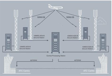
In terms of surveillance, multilateration serves both ground and air traffic monitoring. MLat sensors, which act as transmitters and receivers, can be placed within airport boundaries for ground surveillance or positioned nearby to track incoming and outgoing traffic. Additionally, they can cover larger areas where traditional radar might not be effective. When one of the MLat sensors sends an interrogation signal, the vehicle or aircraft transponder responds. This reply is received and processed by all MLat sites, allowing for precise determination of the vehicle or aircraft’s position through TDOA variations. Furthermore, MLat sensors can also receive and interpret GPS data from aircraft via their Automatic Dependent Surveillance Broadcast (ADS-B) transmissions.
")