In a bold initiative aimed at elevating the ocean’s significance on the agenda of African decision-makers, the Government of South Africa has unveiled a groundbreaking tool in celebration of the 5th annual Marine Protected Areas (MPAs) Day on August 1st. This new series of interactive digital maps, or digi-maps, is designed to empower recreational and leisure users of South Africa’s coastline—particularly anglers, divers, and ocean sports enthusiasts—by providing crucial information about marine protected areas and the regulations governing them. These maps use an intuitive color-coded system that allows users to easily discern where MPAs are located, what activities are permissible, and what actions can be taken to avoid unintentional infringements.
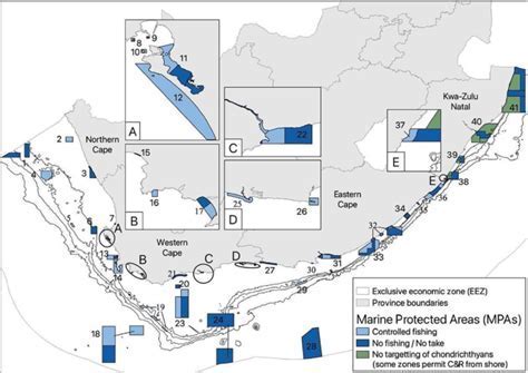
Marine Protected Areas represent regions of ecological significance in our oceans, where biodiversity is legally safeguarded and human activities are regulated to ensure the long-term health of these vital marine ecosystems. Historically, understanding the boundaries and regulations surrounding these areas has posed a challenge for the public; however, the introduction of these digital maps directly addresses that issue. Tailored specifically for inshore MPAs extending up to 40 nautical miles off the coast, the digital charts employ a traffic light color scheme that visually represents various activity types. For example:
- Green zones are designated for general activities such as diving and boating.
- Orange zones indicate areas with restricted usage.
- Red zones signify fully protected no-take areas where all forms of extraction, including fishing, are strictly prohibited.
Each section of the map is further enhanced with succinct bullet-point summaries of key rules, making it easier for users to comprehend the regulations at a glance. By leveraging smartphones and enabling location services, users can track their real-time position in relation to MPA boundaries, thus proving invaluable for boaters and anglers alike.
The overarching goal of this initiative is to democratize marine conservation, making it accessible and understandable for all. Despite the existence of MPAs for several years, a significant hurdle has been the widespread lack of public awareness, leading to frequent inadvertent violations of regulations. As noted by Dr. Bruce Mann, one of the project leaders, “These maps are revolutionary. For years, we’ve seen confusion and frustration from law-abiding users of the ocean who want to do the right thing and are put off by legalese. Now we have a tool that talks to everyone, and we anticipate that these MPAs will be better adhered to and respected.”
Celebrating Marine Protected Areas Day
MPA Day, celebrated annually on August 1st, serves as a platform for governments, scientists, educators, conservationists, and all ocean enthusiasts to unite in recognition of the ecological and social value that MPAs offer to the people of South Africa. With the launch of these interactive maps, this year’s celebration transcends mere symbolism; it represents a strategic move toward fostering more active public engagement in the protection of marine life. Currently, South Africa boasts 42 MPAs, collectively comprising nearly 5% of the country’s exclusive economic zone (EEZ). These sanctuaries not only provide refuge to countless marine species but also safeguard critical breeding habitats and spawning grounds essential to the fishing industry. Moreover, they contribute to the economy through nature-based tourism and enhance the resilience of marine ecosystems against the adverse effects of climate change.
Positive Impacts on Conservation and Tourism
Officials highlight that the implementation of these digital maps will significantly benefit both conservation enforcement and tourism operations. Field rangers, inspectors, and coastguards will find it much easier to reference MPA boundaries in their duties. In tandem, dive operators, eco-tourism ventures, and fishing charters can better inform clients and plan routes that respect sensitive areas. The surge in marine tourism—especially in coastal provinces like Western Cape, KwaZulu-Natal, and Eastern Cape—suggests that such digital resources will play a pivotal role in securing sustainable development. Local communities that rely on coastal resources stand to gain from reduced conflicts among user groups and improved protection of natural resources.
Future Developments for Marine Conservation
Looking ahead, further enhancements to the map’s accessibility and functionality are planned for subsequent phases of the project. Future updates may include offline capabilities for fishing in remote areas lacking internet access and integration with widely used navigation apps favored by boaters and anglers. Developers are working closely with the Department of Forestry, Fisheries and the Environment (DFFE) to ensure that the digital MPA maps remain current, avoiding the pitfalls of outdated information that could mislead users.
As South Africa prepares to celebrate MPA Day 2025, the launch of these digital maps marks a significant step toward creating a more knowledgeable, participatory, and conservation-oriented public. As articulated by Dr. Daly, “The ocean is our common heritage. But, with the proper tools and understanding, we can all do a better job of being its custodian.”
This innovative approach not only aims to protect marine biodiversity but also fosters a sense of responsibility among citizens, empowering them to take an active role in conservation efforts. By bridging the gap between complex regulations and everyday ocean users, South Africa sets a precedent for other nations striving to enhance marine conservation through technology and community engagement.

")


