
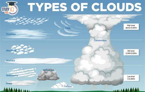
Cumulonimbus, often abbreviated as Cb, is a thick and towering cloud that can stretch high into the atmosphere. It’s usually linked with heavy rain, thunder, and lightning. The mature Cumulonimbus cloud is easily recognizable by its flat, anvil-shaped top.
What Causes Cumulonimbus Clouds?
For a Cumulonimbus cloud to form, three key conditions must be met: first, there needs to be a deep layer of unstable air; second, the air must be warm and moist; and third, a trigger must cause the warm, moist air to rise. This trigger can come from several sources: heating the air near the ground, rising terrain that pushes air upward, or a weather front that forces air to ascend. More details about how these clouds develop can be found in articles discussing the lifecycle of thunderstorms.
Types of Cumulonimbus Clouds
-
Convection: This type typically forms in the late afternoon when the surface air has heated up. These storms are common in tropical regions and are usually single cells that can be avoided when flying around them.
-
Orographic Uplift: When moist, unstable air flows over elevated terrain, Cumulonimbus clouds can develop along ridges or mountains. These storms can be more challenging to avoid due to their linear formation.
-
Mass Ascent: Weather fronts can also force air upwards, leading to Cb formation along the front. These clouds may be embedded in larger frontal clouds, making navigation tricky for aircraft.
Effects of Cumulonimbus Clouds
Cumulonimbus clouds can create several hazards:
-
Turbulence: Inside a Cb, vertical winds can reach speeds of up to 50 knots. The clash of strong updrafts and downdrafts leads to severe turbulence, which can pose risks during takeoff and landing.
-
Icing: Moderate to severe icing can occur, especially at higher altitudes within the cloud.
-
Electrical Disturbances: Aircraft near Cb clouds might face disruptions in communication and navigation systems. A phenomenon called St Elmo’s Fire can indicate nearby Cb activity but isn’t a direct threat to flight safety.
-
Lightning Risk: Planes flying close to Cb clouds are at risk of being struck by lightning.
-
Precipitation: Hail can severely damage aircraft, while other types of precipitation like snow or rain can create hazards on runways.
-
Extreme Weather: Cumulonimbus clouds can produce severe downdrafts, microbursts, and even tornadoes.
How to Stay Safe
Flying into a Cumulonimbus cloud is extremely dangerous, so avoiding them is crucial. Here are some strategies:
-
Planning: While predicting individual Cb cells is tough, forecasters can anticipate conditions that lead to their formation. This information helps flight crews plan routes and manage operations around storms.
-
Awareness: Understanding the conditions that create Cb clouds and recognizing their signs can help pilots and controllers avoid hazards.
-
Weather Radar: This tool is vital for identifying areas of severe turbulence and larger water droplets, which signify the strongest updrafts. However, it’s important to remember that large clouds can absorb radar signals, potentially hiding Cb cells beyond the immediate view.
In-Flight Avoidance
Sometimes, navigating through a line of Cb clouds may be unavoidable if a pilot cannot climb over them. In such cases, they might need to divert significantly to find safe passage. The pilot must carefully assess the best route through these clouds, requiring full crew attention. If a Cb is directly over the destination airport, it’s safer to hold off or divert rather than attempt a landing.
Conclusion
Understanding Cumulonimbus clouds and their associated hazards is essential for safe flying. By staying informed and prepared, pilots can effectively navigate around these formidable weather phenomena.