Overview of Flight Information Regions (FIRs)
Global airspace is organized into nine regions defined by the International Civil Aviation Organization (ICAO), which are often referred to as Global Air Navigation Plan regions. Within these regions, the airspace is further divided into Flight Information Regions (FIRs). This article will explore the basic concepts and definitions related to FIRs while highlighting some challenges faced in managing these areas and improving air traffic control (ATC) capabilities.
What is an FIR?
According to the EUROCONTROL ATM Lexicon, a Flight Information Region (FIR) is “an airspace of defined dimensions within which flight information service and alerting service are provided.” The official source for this definition is ICAO Annex 2 – Rules of the Air, 2005. The EUROCONTROL SASS-C Glossary adds that an FIR is “a three-dimensional area where aircraft are usually controlled by a single authority.” Each FIR can be divided into several geographical areas called sectors, and they may have a combined upper area known as an Upper Information Region (UIR). In some cases, FIRs are also split into lower and upper sections, with the lower section still referred to as an FIR and the upper part designated as a UIR.
FIRs and Their Management
ICAO categorizes each FIR within one of the air navigation regions, including the Africa–Indian Ocean Region (AFI), Asia Region (ASIA), Caribbean Region (CAR), European Region (EUR), Middle East Region (MID), North American Region (NAM), North Atlantic Region (NAT), Pacific Region (PAC), and South American Region (SAM). Each of these nine regions contains different numbers of FIRs. The geographical boundaries of these regions are detailed in Appendix I of the Directives to Regional Air Navigation Meetings and Rules of Procedure for their Conduct (Doc 8144).
Operating procedures for FIRs are outlined in ICAO Doc 7030, which includes technical details and is the official source for procedures related to each FIR. While ICAO’s Standards and Recommended Practices (SARPs) apply universally, FIR data and procedures are specifically tailored for the contracting states involved. The Regional Supplementary Procedures provide the necessary means to implement guidelines from the Performance-Based Communications and Surveillance (PBCS) Manual, ensuring coordination in high seas airspace.
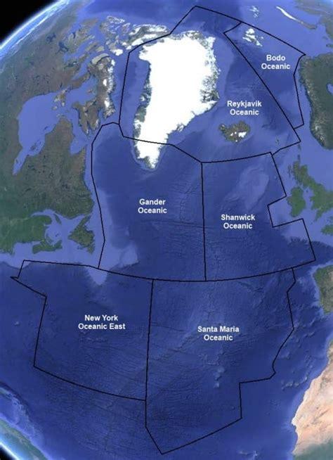
Each FIR is overseen by a controlling authority responsible for providing air traffic services to aircraft operating within it. For instance, the U.K. Civil Aviation Authority manages the FIRs over the U.K., with NATS delivering the air traffic services. FIR sizes can vary significantly; smaller countries may have just one FIR, while larger nations might possess several. Additionally, oceanic airspace is often divided into multiple FIRs assigned to controlling authorities from neighboring countries.
Challenges in FIR Management
In recent years, ICAO presentations have shed light on complex FIR-related issues. Countries in the same air navigation region often need to work together to identify problems and propose changes to Doc 7030, Regional Supplementary Procedures. One of the major challenges has been clarifying which entities hold primary responsibility for FIRs. This challenge has been framed as achieving an “alignment of air navigation plans and regional supplementary procedures.”
For example, in October 2012, it was noted that the areas of applicability in the Regional Supplementary Procedures did not match those in certain air navigation regions. The goal was to simplify procedures for regional performance framework management and effectively plan for ICAO’s long-term Aviation System Block Upgrades. This misalignment caused confusion, leading to duplicated efforts and delays in decision-making.
Another issue highlighted by ICAO involved reaching a consensus among stakeholders in the Asia and Pacific regions regarding changes to minimum longitudinal and lateral aircraft separation in specific FIRs. Stakeholders agreed on a proposed minimum longitudinal separation of 50 nautical miles and a lateral separation of 30 nautical miles, contingent upon proper monitoring and implementation of PBCS.
Other potential risks in FIR management include maintaining standard aircraft separation during transitions between adjacent FIRs, dealing with unexpected flight path changes due to weather, and managing dynamic airspace boundaries. Integration of new technologies with existing systems also presents challenges, particularly when flights rely on performance-based communication and surveillance for traffic separation.
Conclusion
Understanding FIRs is essential for effective air traffic management. As aviation continues to evolve, addressing the challenges within FIRs will be critical for ensuring safety and efficiency in global air travel.


