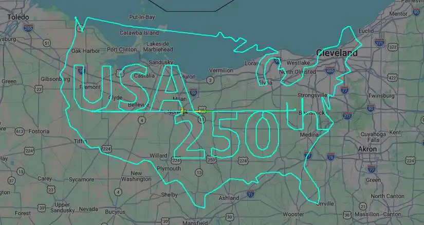
As the United States marks the 250th anniversary of its independence, celebrations have taken many forms, from fireworks and parades to commemorative aircraft liveries. However, one pilot in Ohio chose a far more unusual tribute. By carefully flying a Cessna 182 Skylane RG for approximately six hours, the aviator created an enormous GPS flight track outlining the contiguous United States while spelling out “USA 250th” within its borders.
The remarkable flight quickly gained attention after its tracking data appeared on Flightradar24, drawing aviation enthusiasts from around the world. Rather than carrying passengers on a routine cross-country journey, the aircraft became a flying pen, using precise navigation to transform the skies over northern Ohio into an enormous patriotic canvas. The completed flight path stood as both an impressive feat of planning and a celebration of America’s historic milestone.
Departing from Norwalk Huron County Airport shortly after 6:00 AM, the pilot remained airborne until around lunchtime. Throughout the mission, the aircraft traced the familiar outline of the continental United States between Toledo to the west and Cleveland to the east. The result was a remarkably recognizable map complete with the words “USA 250th” carefully positioned inside the outline.
Precision Flight Planning Turned GPS Data Into Sky Art
Creating aviation artwork on this scale requires considerably more than simply following a rough route. Every turn, heading change, and altitude adjustment must be planned before takeoff to ensure the final GPS track resembles the intended design.
Unlike artistic sketches created on paper, aerial drawings depend entirely on accurate navigation. The pilot had to calculate hundreds of individual course changes while accounting for aircraft performance, airspace restrictions, weather conditions, and available fuel. Even a minor navigation error could have distorted the recognizable outline of the United States or misplaced the lettering inside the map.
The finished track successfully captured many familiar geographic features, including the East Coast, Gulf Coast, Florida Peninsula, Pacific coastline, and the distinctive shape of the continental United States. While some observers pointed out that Alaska and Hawaii were absent from the design, the artwork was clearly intended to depict the contiguous 48 states within the available airspace over Ohio.
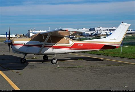
The Cessna 182 Skylane RG Was Well Suited for the Mission
At the center of the story is aircraft N4936T, a 1981 Cessna R182 Skylane RG. According to the Federal Aviation Administration registry, the airplane is owned by Dakma LLC of Parma, Ohio.
The Cessna 182 Skylane RG is one of general aviation’s most respected single-engine aircraft. Unlike the standard fixed-gear Skylane, the RG variant features retractable landing gear, improving aerodynamic efficiency and increasing both climb performance and cruise speed.
Powered for efficient cross-country flying, the aircraft typically cruises at around 173 knots (199 mph / 318 km/h). Its cabin accommodates one pilot and three passengers, although this patriotic flight appears to have focused solely on executing the complex aerial design.
Between 1979 and 1986, the Skylane RG incorporated a wet-wing fuel system capable of carrying up to 92 gallons, with approximately 88 gallons usable. Earlier models carried around 85 gallons, providing the endurance needed for lengthy flights like this one.
A Six-Hour Flight Pushed Endurance Without Exceeding Aircraft Capabilities
Remaining airborne for approximately six hours represents a demanding mission for both aircraft and pilot. Depending on altitude and engine settings, a Cessna 182 Skylane RG typically burns between 11 and 14 gallons of fuel per hour.
Although the flight approached the practical endurance limits of the aircraft, it remained within the Skylane’s operational capabilities when properly planned. Fuel management, weather monitoring, and continuous navigation would all have required careful attention throughout the mission.
Long-duration flights also increase pilot workload, particularly when every maneuver contributes directly to a planned aerial image. Maintaining concentration for six consecutive hours while flying precise headings demonstrates a high level of discipline and preparation.
Aviation Community Celebrates a Creative America250 Tribute
The unusual flight rapidly spread across aviation social media after Flightradar24 highlighted the completed GPS artwork. Aviation enthusiasts praised both the creativity and technical precision involved, with many describing it as one of the year’s most memorable flight-tracking images.
Rather than celebrating exclusively on the ground, the pilot found a uniquely aviation-focused way to recognize the nation’s Semiquincentennial. The flight illustrates how modern GPS tracking has transformed ordinary aircraft movements into a new form of artistic expression, allowing pilots to create massive drawings visible only after landing.
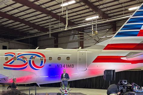
Airlines Are Also Marking America250 in the Skies
The Ohio pilot is not alone in celebrating the nation’s 250th birthday through aviation. Numerous U.S. airlines have introduced special commemorative initiatives honoring America250.
Several carriers have unveiled patriotic liveries, commemorative decals, employee recognition programs, and themed onboard experiences. United Airlines revealed striking Stars & Stripes paint schemes on selected Boeing 737 and Boeing 787 aircraft, while American Airlines, Delta Air Lines, Southwest Airlines, JetBlue, Alaska Airlines, and Allegiant Air have each launched their own America250-themed initiatives.
These efforts celebrate not only the country’s history but also the evolution of American aviation, highlighting the industry’s role in connecting communities over the past two and a half centuries.
A Flight That Will Be Remembered Long After Independence Day
The six-hour Cessna 182 Skylane RG mission transformed an ordinary general aviation flight into a memorable national tribute. Through meticulous planning, disciplined flying, and creative vision, one pilot successfully etched “USA 250th” inside the outline of the United States using nothing more than precise navigation and a single-engine airplane.
While fireworks fade and parades conclude, this remarkable GPS flight path will remain preserved in digital flight-tracking history. It stands as a unique example of how aviation enthusiasts continue finding innovative ways to celebrate America’s milestones, proving that sometimes the most unforgettable artwork is created thousands of feet above the ground.


