In the quiet hours of early Friday morning, western Afghanistan was shaken by a moderate earthquake measuring 4.6 on the Richter scale, once again bringing into focus the volatile geology of a region already on edge. According to the National Center for Seismology (NCS), the tremor occurred at 6:11 AM IST on June 20, 2025, and originated 50 kilometers beneath the Earth’s surface. The epicenter was precisely located at latitude 34.89°N and longitude 62.54°E, deep within the mountainous corridors of Afghanistan’s western highlands. Though no damage or injuries have been officially reported, the event has amplified anxieties across the travel and tourism industry, particularly as the summer season unfolds.
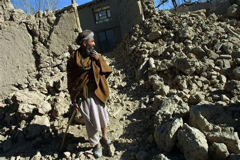
Afghanistan’s history of seismic activity lends a somber gravity to even mild tremors. In this case, residents of Herat, Badghis, and surrounding rural areas described brief but distinct vibrations that caused momentary building evacuations and a flurry of early morning alerts. While local emergency management teams quickly assessed the situation and declared no immediate hazard, the psychological imprint of the quake, especially in a geopolitically tense and infrastructurally vulnerable nation, remains potent.
The Tectonic Anatomy of Western Afghanistan
Afghanistan lies at the crossroads of two powerful geological forces — the Indian and Eurasian tectonic plates. Their slow but unrelenting collision has, over millennia, sculpted the soaring Hindu Kush mountains and caused the Afghanistan-Iran and Afghanistan-Tajikistan border regions to become among the most earthquake-prone in Central Asia. The western regions, particularly Herat Province, have been the focal point of recurring tremors due to the complex fault lines that fracture the landscape beneath.
What makes this seismic event particularly significant is not its magnitude, but its depth and proximity to inhabited areas. While deep-focus earthquakes like this one (50 km below the surface) tend to disperse energy over a larger area, they also have the capacity to unsettle underground fault systems, acting as precursors to stronger seismic events. This underscores why even a seemingly modest quake like Friday’s is being treated with heightened scrutiny by local authorities and international observers alike.
A Sector on Edge: Tourism and Travel Implications
The timing of this earthquake — at the start of the peak summer travel season — has placed pressure on the fragile but slowly re-emerging tourism sector in Afghanistan. In recent years, niche travel operators have begun offering guided tours through historically and culturally significant parts of the country, including Herat’s citadel, Minarets of Jam, and the remote Wakhan Corridor. These excursions often attract seasoned travelers, documentarians, and heritage researchers seeking unfiltered experiences.
However, events like this morning’s quake send ripples of concern through these already niche ventures. Travel agencies, particularly those operating from Dubai, Istanbul, and New Delhi, which funnel high-net-worth individuals and cultural tourists into Afghanistan, are now facing renewed questions about seismic preparedness, emergency response mechanisms, and evacuation protocols.
Embassies and foreign missions have also issued advisories urging caution, recommending travelers avoid non-essential travel to rural western regions over the coming weeks, especially if aftershocks occur. This development has potential economic consequences: hotels, local tour guides, transport providers, and artisanal businesses in the region could face booking cancellations or revenue drops just as they were beginning to gain traction post-pandemic.
Comparison to April’s 5.8-Magnitude Earthquake: Escalating Seismic Narratives
The Friday quake comes on the heels of another seismic event that struck the Afghanistan-Tajikistan border just two months prior, on April 19, 2025. That earthquake registered 5.8 in magnitude and originated at a depth of 86 kilometers, shaking large swaths of northern Afghanistan and sending tremors as far as Delhi-NCR, Srinagar, and parts of Pakistan.
Although both quakes were non-destructive, the frequency of seismic activity in a short time span has raised concerns among geologists, tourism analysts, and humanitarian agencies. The cumulative nature of these events, especially in a country with limited disaster resilience, has led some experts to warn that a larger event could be building — a sobering possibility given Afghanistan’s recent history.
Infrastructure Fragility: A Silent Hazard
Even without catastrophic consequences, each earthquake in Afghanistan exposes the structural vulnerabilities of its urban and rural built environments. Many buildings, particularly in rural provinces, are made from mudbrick or loosely bound masonry, lacking steel reinforcement or modern architectural standards. This poses a lethal risk should a more violent tremor strike.
Compounding the issue is the scarcity of seismic retrofitting programs and the absence of updated building codes in many provincial jurisdictions. International NGOs and UN agencies have made sporadic attempts to support infrastructure modernization, but sustained funding and governance challenges often limit long-term impact. Consequently, even a 4.6-magnitude event must be regarded as a trial warning, a signal to reinforce emergency readiness and build community-level resilience through education and structural adaptation.
Emergency Response and Monitoring: Mixed Capacity, Persistent Gaps
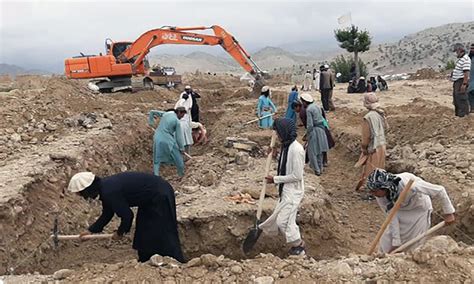
In the hours following the earthquake, Afghanistan’s National Disaster Management Authority (ANDMA), in collaboration with international seismic observatories, conducted rapid reconnaissance. These evaluations confirmed that the quake had no major humanitarian toll. However, they also revealed the gaps in real-time monitoring infrastructure, especially outside Kabul.
Most of Afghanistan’s seismic data comes from foreign networks, with limited domestic sensor coverage in the western mountain ranges. The delay in cross-verifying epicenter data and magnitude readings, which can be critical in assessing aftershock risks, continues to hamper swift policy responses. To this end, experts from the Asian Seismological Commission have reiterated calls for a regional seismic monitoring framework, which would integrate Afghanistan’s data with neighboring Tajikistan, Iran, and Pakistan.
Rising Traveler Anxiety and Insurance Repercussions
This latest earthquake has introduced fresh complications for travel insurance providers, many of whom were already cautious about extending coverage for Afghanistan-bound journeys. Policyholders are now scrutinizing “acts of God” clauses, particularly regarding trip cancellations, medical evacuation, and property loss in the event of a natural disaster.
Operators such as GeoAdventure Travel, Central Silk Routes, and Afghan Expeditions are facing demands for detailed risk assessments, on-the-ground partner certifications, and in some cases, earthquake-specific itinerary amendments. These operational adjustments could lengthen lead times for bookings and increase costs — factors that strain a sector still in its infancy.
Local Resilience and Public Awareness Campaigns
While government capacity remains limited, community-led preparedness initiatives are becoming increasingly important. In several parts of Herat and Farah provinces, local NGOs have begun implementing earthquake safety drills, constructing emergency gathering points, and distributing educational material on what to do during a seismic event. These grassroots responses, though modest in scale, represent the frontline of resilience in a country often left to fend for itself when natural disasters occur.
Moreover, with mobile phone penetration on the rise — especially through low-cost satellite communications in remote areas — NGOs are collaborating with tech providers to broadcast early warning alerts and post-quake advisories via SMS and voice systems, bypassing the need for internet access.
Looking Ahead: Structural Planning and International Assistance
The June 20 earthquake is another critical marker in Afghanistan’s ongoing struggle with natural hazards, compounded by a geopolitical context that limits long-term infrastructure investment. Analysts argue that improving resilience against seismic threats must become part of a broader national recovery strategy, incorporating urban planning, disaster mitigation, and foreign aid coordination.
Key recommendations emerging from international geophysical panels include:
- Establishing a national seismic risk map, updated annually.
- Mandating earthquake-resistant design standards in new constructions.
- Training local construction workers in seismic safety protocols.
- Deploying affordable sensor networks in seismic hotspots for real-time data flow.
- Encouraging cross-border cooperation with Iran, Pakistan, and Central Asia for emergency response.
Conclusion: A Wake-Up Call Beneath the Surface
Though the 4.6-magnitude earthquake in western Afghanistan passed without devastation, its implications are far-reaching. It has unsettled locals, shaken confidence among adventurous travelers, and reignited the conversation around Afghanistan’s preparedness for natural disasters. As the region grapples with cascading crises — economic, political, and environmental — each tremor becomes a test of institutional readiness and human resilience.
The next seismic event may not be as forgiving. But if this tremor prompts meaningful action — improved monitoring, smarter infrastructure, better-informed travelers, and more empowered local communities — it may yet become a pivotal chapter in Afghanistan’s path toward safety and stability.


