Understanding the Segmented Circle: A Visual Guide for Pilots
In the realm of non-towered airport operations, the segmented circle stands as a critical visual aid, offering indispensable traffic pattern and landing information. For pilots navigating these airfields, particularly student aviators preparing for the FAA Private Pilot Knowledge Test, mastering the interpretation of segmented circles is non-negotiable. These ground-based indicators condense a wealth of navigational cues into a unified system visible from the sky — ensuring safer, more informed flight operations.
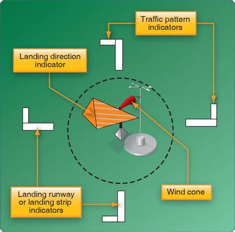
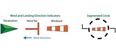
The segmented circle is not just a collection of random shapes painted on a field. It is a strategic tool comprised of three primary components: landing runway indicators, traffic pattern indicators, and a wind cone. When deciphered correctly, these symbols inform the pilot which runway is in use and whether to enter a left-hand or right-hand traffic pattern.
Purpose and Placement of the Segmented Circle
The segmented circle is prominently placed near the center of the airfield, visible from overhead to incoming aircraft. Airports that lack control towers rely on this system to communicate basic traffic operations to pilots, eliminating guesswork in critical phases like approach and landing. Its utility is especially pronounced in training environments or rural airports where radio communications may be limited or nonexistent.
Key functions of the segmented circle include:
-
Indicating the active runway orientation
-
Showing the wind direction via a windsock or wind cone
-
Specifying whether a left-hand or right-hand pattern is to be followed
This compact system replaces verbal instructions that a towered airport would typically provide.
Component 1: Wind Cone – Reading Wind Direction
The wind cone, often referred to as a windsock, plays a pivotal role in determining the optimal landing direction. Pilots always aim to land into the wind to reduce ground speed during touchdown. The wind cone aligns itself naturally with the prevailing wind, its opening pointing into the wind’s origin.
For example, if the wind cone is pointing southeast, the wind is coming from that direction. A pilot must then choose a runway heading northwest, aligning the aircraft’s nose into the wind upon landing.
Component 2: Runway Landing Indicators
Two straight lines or bars positioned opposite each other inside the segmented circle represent the runway orientation. These do not depict specific runway numbers. Instead, they illustrate a general alignment — such as north-south or east-west — helping pilots infer which actual runway designation (e.g., 18/36 or 09/27) to use.
Runways in the United States are labeled based on their magnetic heading, rounded to the nearest 10 degrees. For instance:
-
Runway 9 faces 090° (East)
-
Runway 27 faces 270° (West)
-
Runway 36 faces 360° (North)
-
Runway 18 faces 180° (South)
By matching the runway alignment in the segmented circle with options provided in a test question or sectional chart, pilots can infer the precise runway number to be used.
Component 3: Traffic Pattern Indicators
Perhaps the most misunderstood elements are the traffic pattern indicators. These are “L” shaped figures located adjacent to the runway indicators within the circle. Each “L” is directional:
-
The long leg signifies the final approach (runway alignment)
-
The short leg shows the base leg of the traffic pattern
By imagining an aircraft on the base leg, preparing to turn final, the direction of the turn required to line up with the runway becomes evident. If a left turn is needed, the traffic pattern is left-hand. If a right turn is needed, then it’s right-hand traffic.
Example Case: Decoding Figure 50 on the FAA Knowledge Test
Consider the question: Which runway and traffic pattern should be used as indicated by the wind cone in the segmented circle?
Choices:
-
A. Left-hand traffic on Runway 9
-
B. Right-hand traffic on Runway 27
-
C. Right-hand traffic on Runway 36
First, observe the wind cone. If it’s pointing from the northwest, aircraft should land on a northbound or westbound runway — thus eliminating Runway 9 (eastbound) from consideration.
That leaves Runway 27 (westbound) and Runway 36 (northbound). Now examine the L-shaped traffic indicators.
For Runway 36, if the base leg requires a left turn to align with the final approach, then left-hand traffic applies. But since option C says right-hand traffic on Runway 36, it’s incorrect.
Turning to Runway 27, if the indicators show a right-hand turn from base to final, then right-hand traffic is appropriate — matching Option B.
Thus, the correct answer is B. Right-hand traffic on Runway 27.
Common Misconceptions About Segmented Circles
Despite their clarity, segmented circles often cause confusion. Common pitfalls include:
-
Mistaking the wind cone’s tail for the wind’s origin
-
Misreading the short leg of the “L” as the final approach, rather than the base leg
-
Assuming the indicators show runway numbers directly
Application in Real-World Scenarios
Many small, rural, or general aviation airports across the U.S., such as those in Arizona, Nebraska, or upstate New York, rely exclusively on segmented circles for pattern control. Flight instructors emphasize early mastery of these diagrams to reinforce situational awareness and encourage self-reliant decision-making.
Even experienced pilots refer to segmented circles when visiting unfamiliar fields, particularly during cross-country VFR flights. Misinterpreting a segmented circle can lead to incorrect pattern entries — endangering both aircraft and ground operations.
Integration with Sectional Charts and Flight Planning Tools
Segmented circles may not be illustrated on sectional charts, but their presence is often indicated in the Chart Supplement U.S. (formerly Airport/Facility Directory). Preflight planning should include reviewing traffic patterns, wind history, and segmented circle configurations where applicable.
Modern EFBs (Electronic Flight Bags) like ForeFlight or Garmin Pilot may include airport diagrams with segmented circle overlays. However, nothing substitutes the visual confirmation from the air during pattern entry.
Conclusion: Why Mastering Segmented Circles Matters
Mastering the interpretation of segmented circles is not merely a theoretical exercise. It is a critical aviation safety skill that can prevent midair conflicts, ensure orderly traffic flows, and reinforce a pilot’s spatial orientation.
Whether preparing for the Private Pilot Knowledge Test or approaching a remote airstrip, understanding how to decode the wind cone, identify the runway alignment, and determine traffic pattern direction using the segmented circle is essential to becoming a confident and competent pilot.
Frequently Asked Questions (FAQ)
What is the main purpose of a segmented circle?
A segmented circle provides traffic pattern information at airports without control towers. It shows runway orientation, wind direction, and whether left-hand or right-hand traffic should be used. This visual system aids pilots during arrival and approach when radio communication is unavailable or minimal.
How can you tell if a segmented circle requires a left or right traffic pattern?
By examining the “L” shaped indicators within the circle. The long arm indicates the final approach leg, while the short arm shows the base leg. Visualizing an aircraft flying the base leg, the turn needed to align with final reveals whether it’s left- or right-hand traffic.
Are runway numbers shown in the segmented circle?
No, runway numbers are not depicted in segmented circles. Instead, the orientation of the landing indicators suggests the runway alignment. Pilots must infer the exact runway number based on this orientation and information provided elsewhere, such as in test questions or airport directories.


