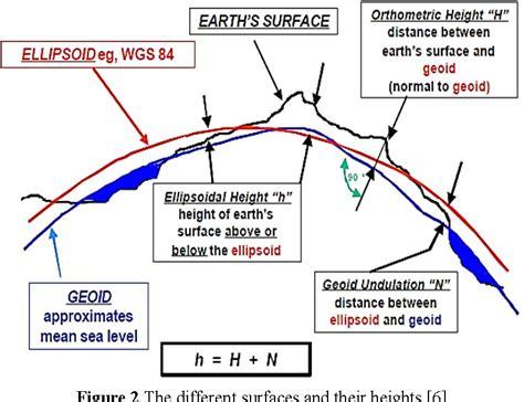
The World Geodetic System 1984, commonly known as WGS84, is a global reference system for mapping and navigation. It provides a framework for determining precise locations on Earth. This system is crucial for GPS technology, helping users pinpoint their location accurately.
WGS84 has an interesting history, evolving from earlier geodetic systems. It was established to improve global positioning accuracy, making it essential for various applications. Over time, it has been updated to incorporate advancements in technology and geodesy.
Compliance with WGS84 is vital for international coordination in aviation and other fields. Many countries have adopted this system to ensure consistent data across borders. This compliance helps prevent confusion and errors in navigation.
In some regions where WGS84 is not the standard, pilot actions are crucial. These pilots must rely on alternative methods to navigate effectively. Understanding how to adapt is key to maintaining safety and efficiency in non-WGS84 airspace.