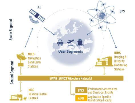
The European Geostationary Navigation Overlay Service, or EGNOS, is a satellite-based augmentation system designed to improve the accuracy of the Global Positioning System (GPS). It offers Europeans more precise positioning data, which can enhance existing services and inspire new developments. EGNOS achieves this by using a network of ground-based monitoring stations to calculate corrections for GPS signals, which are then broadcast from geostationary satellites. This system addresses errors caused by the ionosphere and issues within the broadcast signal itself, resulting in higher accuracy and better integrity monitoring compared to GPS alone.
As an augmentation system, EGNOS can enhance GPS positioning accuracy to within three meters. In contrast, a standard GPS receiver without EGNOS can only determine a position within 17 meters. Additionally, EGNOS verifies the integrity of the navigation system, ensuring users can trust the accuracy of their location information. It also provides timely warnings if the system or its data becomes unreliable, which is crucial for safety-critical applications in aviation and maritime industries, where incorrect location signals could endanger lives.
EGNOS operates through a robust infrastructure that includes three geostationary satellites positioned over Europe and a network of ground stations. Since it relies on GPS technology, integrating EGNOS does not require significant changes to existing receivers. Many GPS devices on the market today are already EGNOS-enabled. The development of EGNOS was a collaborative effort involving the European Space Agency (ESA), the European Commission (EC), and Eurocontrol, the organization responsible for air navigation safety in Europe. EGNOS is also the precursor to GALILEO, the global navigation satellite system being developed by the European Union. Both EGNOS and GALILEO are managed under Europe’s GNSS programs by the European Commission.
EGNOS offers several services to its users. The Open Service is available free of charge to anyone with an EGNOS-enabled satellite navigation receiver and was launched on October 1, 2009. The Safety-of-life Service provides critical integrity messages that alert users to any GPS signal malfunctions within six seconds, making it vital for applications where safety is paramount. This service was certified for civil aviation in 2011. Additionally, the EGNOS Data Access Service (EDAS) allows ground-based access to EGNOS data via the Internet. EDAS connects users to EGNOS’s ground infrastructure, providing valuable data even in areas where EGNOS satellites may not be visible, such as urban canyons, and supports various value-added services, applications, and research programs.
Moreover, certain SBAS equipment can now display vertical guidance for published RNAV(GNSS) approaches. While having this vertical guidance is beneficial, pilots should remember that many RNAV(GNSS) approach procedures are classified as Non-Precision Approaches or rely solely on Barometric Vertical guidance. Therefore, even with Advisory Vertical Guidance available, pilots must adhere to the published minimum descent altitudes associated with LNAV minima and follow the missed approach procedures.
")

")
")

")


")