The need for effective air navigation services and facilities led to the division of the Earth into various “regions.” These regions help address specific air navigation challenges that share similar conditions. For each region, Regional Supplementary Procedures (SUPPS) are created and published in ICAO Doc 7030: Regional Supplementary Procedures. It’s important to note that these procedures should align with ICAO Annexes or PANS but do not hold the same status as SARPS. While SARPS are recommended for global use by Contracting States, SUPPS are tailored for specific flight information regions.
Initially, in 1945, the world was divided into ten air navigation regions: North Atlantic, European-Mediterranean, Middle East, Caribbean, South East Asia, South Atlantic, South Pacific, North Pacific, South America, and African-Indian Ocean. A review in 1952 reduced the number of regions to eight by merging the North and South Pacific regions, as well as the South American and South Atlantic regions. However, by the late 1950s, a new reorganization was needed to address issues like overlapping regions and the exclusion of certain areas. This was finalized in 1964.
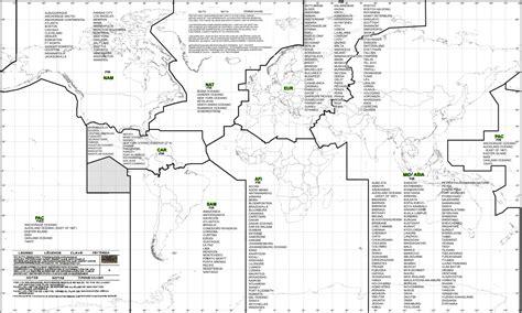
The updated structure increased the regions to nine, eliminating overlaps, including polar areas, and changing the name of the European-Mediterranean Region to the European Region. A North American Region was established, covering Canada, the United States, and the associated polar area. In 1980, the South East Asian Region was renamed the Asia Region.
Today, the regional structure includes the following regions: Africa-Indian Ocean Region (AFI), Asia Region (ASIA), Caribbean Region (CAR), European Region (EUR), Middle East Region (MID), North American Region (NAM), North Atlantic Region (NAT), Pacific Region (PAC), and South American Region (SAM). Understanding these regions is crucial for navigating our skies effectively.
")


