
West Michigan is currently facing a fast-escalating weather emergency as strong to severe thunderstorms sweep across the region, raising alarms about travel delays, road hazards, and emergency responses. This isn’t just a localized issue—it’s a multi-state crisis that includes Central Illinois, Jacksonville, Southern and Central Indiana, and Washington, DC. As the skies darken, the urgency of the situation becomes increasingly apparent. With tornado warnings and severe thunderstorm alerts cascading across state lines, travelers should brace for potential disruptions that could unravel their plans in mere moments.
The National Weather Service has issued a Severe Thunderstorm Watch for the majority of southern West Michigan, extending until 10 p.m. on Thursday, June 19, 2025. A line of storms is racing northeast with impact windows estimated from 3 p.m. to 8 p.m. These sudden and severe weather changes have caused widespread anxiety among tourists, business travelers, and residents alike, leaving many scrambling to adjust their plans and ensure their safety.
Tornado and Thunderstorm Warnings Activate Emergency Response
As the afternoon progressed, the pace of severe weather warnings accelerated dramatically. By 5:09 p.m., St. Joseph and Branch Counties were placed under a Severe Thunderstorm Warning, with Ingham County following suit. Earlier in the day, Berrien County also received a warning. Furthermore, a Tornado Watch remains active for Branch, Cass, Berrien, and St. Joseph Counties until 7 p.m. The speed and intensity of these storm cells are alarming, especially as they approach key towns such as Coldwater and Hillsdale, with arrival estimates indicating that the strongest cells could reach these areas by 5:30 p.m. This leaves travelers with very little time to make necessary safety adjustments.
Airport Delays and Road Travel Disruptions Escalate
For those attempting to fly in or out of regional airports like Kalamazoo/Battle Creek International or Capital Region International in Lansing, delays are becoming increasingly likely. The combination of reduced visibility and increasing wind gusts is prompting airlines to closely monitor conditions. Some may even decide to delay or divert flights altogether, adding another layer of complexity to travel plans during this already chaotic time.
Meanwhile, ground travel along major routes such as I-94 and U.S. 131 is becoming perilous. Sudden bursts of rain, combined with lightning and strong winds, are compromising visibility and creating hazardous conditions. Local authorities are urging motorists to avoid travel unless absolutely necessary, which poses a significant challenge for tourists en route to popular destinations like beach towns and nature trails. The need for travel safety has quickly shifted from a matter of convenience to a critical necessity.
Hotels and Local Businesses Brace for Guest Impact
In response to the impending storm, hotels across West Michigan are activating their emergency protocols. Many establishments are preparing interior shelter areas, relocating guests away from windows, and stocking essential supplies in anticipation of potential power outages. Staff members have been trained to respond swiftly during tornado watches, prioritizing guest safety above all else. Tourism businesses, from outdoor excursions to cultural attractions, are either pausing operations or closing early, working closely with local officials and weather services to protect visitors and reduce exposure during the volatile hours ahead.
For travelers already checked in, the storm may transform what was intended to be a casual overnight stay into a tense shelter-in-place situation. The atmosphere has drastically shifted, from excitement over summer travel to caution and concern as the storm approaches.
Summer Travel Takes a Hit as Storm Risk Rises
This severe weather event comes at a particularly inconvenient time for West Michigan’s summer tourism, a season that typically sees an influx of visitors. With schools out and vacation bookings peaking, local towns and attractions had been preparing for a midweek surge of tourists. However, the unpredictability of nature has thrown a wrench into these plans. Many events have been postponed, and tourism boards are now redirecting their messaging to prioritize storm safety. Airlines and rail services are issuing advisory notices, warning travelers of potential cancellations and reduced service windows. The emotional toll is mounting as well, with many travelers who had been looking forward to lakeside relaxation or scenic drives now glued to radar maps, anxiously awaiting updates on the storm’s trajectory.
Why This Storm Is So Dangerous
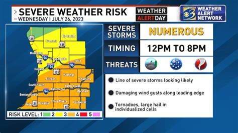
The Storm Prediction Center has designated most of West Michigan under an “enhanced risk” for severe weather, rated level 3 out of 5. This is not a trivial threat; enhanced risk days are notorious for producing fast-moving storm cells capable of delivering large hail, damaging winds, and isolated tornadoes. Even areas categorized under a “slight risk” still face considerable dangers, including flash flooding and structural damage. The unpredictable nature of storm paths only intensifies concerns, as updates can shift dramatically within minutes. Local authorities are coordinating closely with emergency responders to prepare for potential power outages, tree damage, and possible evacuations should conditions worsen.
What You Need to Do Right Now
If you find yourself traveling through or staying in West Michigan, now is the time to take action. Here are several crucial steps to consider:
- Check with your airline for delays or rebooking options. Stay updated on flight statuses to avoid unnecessary inconveniences.
- Avoid non-essential driving, especially in storm-affected counties, to minimize risk.
- Locate the nearest safe shelter if you’re in a hotel or unfamiliar area, ensuring you know where to go in case of an emergency.
- Charge your devices, keep your weather apps open, and stay tuned to local alerts for real-time updates.
- Delay or adjust your travel plans until the storm system clears to ensure your safety.
Taking these precautions can make a significant difference between mere inconvenience and potential danger for both locals and visitors.
The Bigger Picture: Extreme Weather and Travel Risks Are Rising
This severe weather episode is part of a broader pattern affecting the United States in 2025. From wildfires in the West to flooding in the Southeast, climate volatility is reshaping the landscape of travel and tourism. Year-over-year increases in weather-related disruptions mean that travel providers must now account for sudden storms, even in regions known for their mild summer conditions, such as Michigan. In response, tourism boards are investing in emergency readiness campaigns, airlines are incorporating greater flexibility into fare structures, and travelers themselves are becoming more cautious—opting for insurance, planning for potential delays, and frequently checking forecast apps alongside their boarding passes.
Final Thought: Stay Aware, Stay Safe
Wednesday’s storm threat in West Michigan is not merely an ordinary forecast; it is a test of readiness for travelers, airlines, and the entire tourism ecosystem. With multiple watches and warnings in effect, the immediate priority must be safety and smart planning. If you’re in the region or heading that way, monitor updates hourly. The storm will eventually pass, but how we respond now will define the story of tomorrow.


