As of June 18, 2025, St. Louis finds itself under a severe weather alert, joining the ranks of Lansing, Grand Rapids, Ann Arbor, Alton, Edwardsville, Belleville, and Bowling Green in facing an imminent tornado threat. What began as a typical summer morning has rapidly escalated into a day filled with anxiety, emergency alerts, and fast-moving storm systems. The skies above St. Louis and these neighboring cities are shifting dramatically, creating a critical juncture for both locals and travelers alike. Emergency sirens have sounded through Belleville and Edwardsville, while weather trackers highlight the same threat level impacting Lansing and Grand Rapids. This situation is evolving quickly, and those residing in or visiting Ann Arbor and Bowling Green are nervously watching the skies.
This isn’t just another storm; it’s a burgeoning crisis that could dramatically affect travel, safety, and plans in an instant. Understanding what tourists need to know right now could mean the difference between danger and preparedness. The unfolding details are indeed alarming.
Tornado Threat Puts St. Louis Travel and Tourism Industry on High Alert
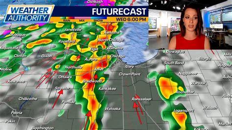
The St. Louis region is gearing up for a potentially dangerous storm system, as a tornado watch was issued Wednesday morning, affecting dozens of counties across Missouri and Illinois until 4 p.m. The escalating storm threat, intensified by a confirmed tornado sighting in northwestern Calhoun County, is already sending ripples through the local travel and tourism economy. As summer reaches its peak, this sudden weather event poses risks not only to physical safety but also to mobility, business operations, and traveler confidence.
Local airports, hotels, and hospitality businesses are making swift adjustments to their operations in anticipation of the impending storm. Airlines are closely monitoring developments, while hotel properties throughout the metro area are alerting guests about potential disruptions. For visitors exploring the vibrant bi-state region, this abrupt weather shift necessitates sudden detours, itinerary changes, and real-time safety decisions.
Which Communities Are Affected? A Widespread Emergency
The tornado watch encompasses a vast area, covering nearly every corner of the St. Louis metropolitan region. The most vulnerable areas are now closely monitoring wind gusts, hail, and rotating storm cells. In Missouri, the counties under watch include:
- St. Louis City
- St. Louis County
- St. Charles
- Jefferson
- Lincoln
- Cape Girardeau
- Perry
- Madison
- Pike
- St. Francois
- Ste. Genevieve
- Bollinger
Across Illinois, even more counties are affected, including:
- St. Clair
- Madison
- Calhoun
- Monroe
- Jersey
- Randolph
- Macoupin
- Clinton
- Bond
- Marion
- Jefferson
- Clay
- Fayette
- Greene
- Montgomery
- Washington
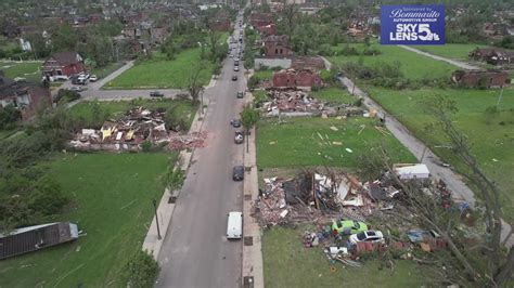
This watch follows an earlier tornado warning that has since been narrowed to include parts of Illinois’ Pike County, where rotation was observed and damage reported.
Severe Weather Meets Peak Travel Season
For the travel and tourism industry, the timing of this storm couldn’t be more disruptive. With summer tourism surging, both leisure travelers and business visitors are arriving in high numbers. Events, concerts, conventions, and outdoor festivals are in full swing across St. Louis City and County. However, with a Level 2 and 3 out of 5 storm risk issued by the Storm Prediction Center, event planners are scrambling to adjust.
Cancellations, postponements, and emergency protocols have now become part of the daily rhythm. Tourists in hotels, parks, and shopping centers are receiving urgent alerts. Downtown hotels are briefing guests on shelter-in-place procedures, ensuring everyone is aware of the safest options available. Additionally, regional travel agencies and online booking platforms have begun issuing updates to clients traveling in or near the impacted areas, with many offering free rebooking options or guidance on travel insurance claims as storms threaten to ground flights or disrupt interstate travel.
Airlines and Airports: Bracing for Weather-Induced Disruption
St. Louis Lambert International Airport remains operational, but the heightened alert levels are causing concern. Airlines are monitoring wind speeds and thunderstorm activity on an hour-by-hour basis. Arrivals and departures may face delays, particularly during the most volatile weather windows, which are expected between noon and 10 p.m. Wednesday. Private pilots and regional air services are exercising extreme caution, as turbulent wind shear and low visibility make smaller aircraft especially vulnerable. Furthermore, connecting flights through the Midwest may also experience downstream delays as this storm system impacts other hubs.
Tourism and Economic Impact: A Costly Weather Shift
The St. Louis region has recently enjoyed a robust tourism recovery in 2024, with hotel bookings, attraction attendance, and event schedules bouncing back to pre-pandemic levels. Yet, intense weather such as this creates a significant economic setback. Local attractions—like the Gateway Arch, Forest Park, Missouri Botanical Garden, and St. Louis Zoo—often close or modify their hours in response to tornado watches, resulting in lost visitor spending and diminished traveler satisfaction. In rural counties such as Ste. Genevieve, Calhoun, and Jefferson, where heritage tourism and agritourism are flourishing summer draws, visitors are now faced with sudden road closures and itinerary interruptions.
A Growing Storm Season Strains Emotional Resilience
Beyond the logistical challenges, there’s an emotional weight to this year’s storm season. The bi-state region has already witnessed multiple rounds of severe weather this spring, including damaging winds, power outages, and flash flooding. For residents and repeat visitors alike, the sound of sirens and alerts now resonates with deeper anxiety. Hospitality teams are focusing on compassion-driven service, offering guests not just safety plans but also empathy and reassurance during these unsettling times.
How to Stay Safe if You’re Traveling in the Region
If you find yourself currently in the St. Louis area or planning to arrive soon, it is crucial to stay informed and prepared. Here’s what you need to keep in mind:
- Download local weather apps equipped with real-time tornado and thunderstorm alerts to stay updated on changing conditions.
- Familiarize yourself with your hotel’s emergency plan. Don’t hesitate to ask the front desk about the safest place to shelter in case of a tornado warning.
- Avoid long drives through rural areas between noon and 10 p.m. Storms may develop rapidly and significantly reduce visibility.
- Stay informed by following local news and the 5 On Your Side Weather Impact Team, which provides live updates on the evolving situation.
- Have a backup plan in place. Allow flexibility in your itinerary and consider indoor attractions as alternative options should outdoor activities become unsafe.
Weather Forecast Outlook: More Storms Ahead?
While it’s true that not everyone in the alert zones will experience severe weather, the threat is palpable. The ingredients for thunderstorms—moisture, lift, and instability—are prevalent across much of the region. This means thunderstorms can form swiftly, turning calm skies into fast-moving, high-impact events. The National Weather Service is closely monitoring the system and may issue additional warnings or advisories as conditions evolve. Unfortunately, this may not be the last weather threat we encounter this summer.
As summer travel hits full stride, a series of rapid-fire storms and tornado watches are disrupting travel across parts of the Midwest, affecting major hubs in Missouri, Illinois, Michigan, and even Nebraska. With June 18, 2025, shaping up to be one of the most weather-active days of the season, both residents and tourists are feeling the impact of these sudden changes to their plans. From grounded flights to delayed road trips, the repercussions are being felt far and wide.
St. Louis and Central Illinois: At the Heart of the Tornado Zone
The St. Louis metro area and large segments of central Illinois remain under a tornado watch until 4 p.m. CDT. More than two dozen counties have been affected, including high-traffic areas like Madison, St. Clair, St. Louis County, and Pike County, where a confirmed tornado touched down earlier today. Airports in the region, including St. Louis Lambert International, continue to operate, yet delays are anticipated. Outdoor attractions and city tours are being either suspended or rerouted as severe weather approaches. Rapid travel alerts are being disseminated to keep both locals and visitors informed of the heightened risk.
Michigan on Edge: Thunderstorms with Tornado Potential
Further north, southern Michigan cities such as Lansing, Grand Rapids, and Ann Arbor are bracing for potential tornadoes and large hail later this afternoon and evening. Storm activity is predicted to peak between 3 and 10 p.m., posing threats not only to commuter traffic but also to summer events and leisure travel across the state. Travelers in Michigan should prepare for last-minute adjustments to their itineraries. Hotel staff are urging guests to stay indoors and adhere to all severe weather protocols, while airlines serving Detroit Metropolitan Airport are keeping a vigilant eye on weather developments.
A Tornado Under a Rainbow in Nebraska
In a bizarre and surreal turn of events, a tornado was spotted crossing beneath a rainbow in Dickens, Nebraska, earlier today. Though isolated, this occurrence underscores the unpredictability and widespread nature of today’s weather instability. Even regions not typically known to experience tornadoes this time of year are witnessing drastic swings in weather patterns. For road trippers journeying through the Great Plains, this serves as a poignant reminder to monitor forecasts diligently and be prepared to alter routes as necessary.
What Travelers Need to Do Now
For anyone visiting or passing through these regions today, the key lies in flexibility and vigilance. Stay indoors when warnings are active, and avoid driving through rural areas experiencing low visibility. Regularly check airline updates and do not hesitate to rebook should conditions change unexpectedly. Many hotels are now conducting shelter-in-place briefings to ensure guest safety. If you’re staying in a metro area like St. Louis or Detroit, familiarize yourself with the nearest storm shelter or safe room within your accommodation.
Final Thoughts: When Weather Becomes the Destination
Today, the Midwest serves as a stark reminder to travelers that nature can alter plans in mere moments. From tornado watches in Illinois to hailstorms in Michigan, June 18 stands as a day to prioritize safety over tourism. However, with smart decisions and timely alerts, travelers can navigate this turbulence. Sometimes, the greatest adventure lies in simply arriving safely.
Conclusion: When Weather Disrupts Wonder
St. Louis is renowned for its charm, history, and Midwestern hospitality. Yet days like today illustrate a powerful lesson: nature doesn’t always adhere to our plans. As the region endures another intense weather cycle, the travel and tourism industry must adapt, balancing safety, economic impact, and traveler well-being. For visitors, flexibility and awareness will prove invaluable allies. For the industry, the focus remains clear—keep people informed, sheltered, and safe. Storms may rattle the skies, but resilience is the heartbeat of the Gateway City.


