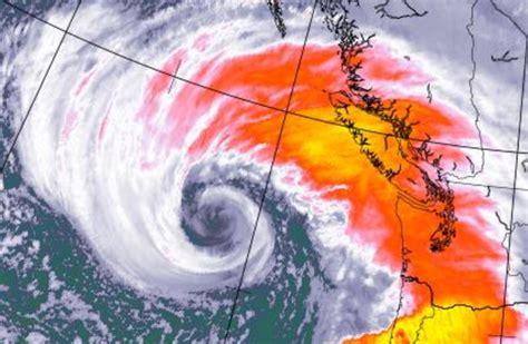
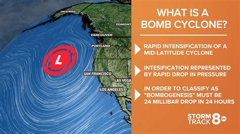
A powerful low-pressure system off the coast of New South Wales (NSW), classified as a bomb cyclone, is wreaking havoc across multiple regions, including the Hunter Region. The storm is bringing dangerous surf, strong winds, torrential rainfall, and potential flooding, creating hazardous conditions. As the storm moves southward, residents and travelers are urged to stay alert and follow official government warnings.
Overview of the Bomb Cyclone
The Australian Bureau of Meteorology (BOM) reports that the bomb cyclone has rapidly intensified, causing widespread disruption along the NSW coastline. Some areas are predicted to experience up to 100mm of rain over the next 24 hours, while winds could reach speeds of up to 130 km/h. The combination of strong winds and heavy rainfall poses significant risks, particularly along coastal roads and highways. Severe weather warnings have been issued for multiple regions, urging residents to secure property and avoid unnecessary travel. For real-time updates on wind speeds, rainfall, and potential flooding, residents are advised to monitor the BOM and Transport for NSW websites.
Travel Disruptions and Safety Advice
Travel disruptions are rampant across the affected areas. Several roads are closed or flooded, and train services are delayed due to fallen trees and flooding. The State Emergency Service (SES) has been working tirelessly to clear roads and restore access, but some rural areas remain inaccessible. Travelers are encouraged to avoid non-essential travel, especially in flood-prone regions, and to keep updated via Transport for NSW and the SES. It is crucial to stay informed about road closures, diversions, and delays to ensure safe travel.
Flooding and Infrastructure Damage
The BOM has highlighted that sustained rainfall could rapidly raise river levels, causing flooding in several areas, including parts of the Hunter Valley. Minor flooding has already been reported, and the risk of major riverine flooding remains high if the rain persists. The SES has mobilized flood mitigation teams, including sandbag distribution in high-risk areas. Property owners are urged to prepare for possible flooding and regularly check flood warnings on the NSW Government website.
Power Supply and Blackouts
Power outages have been reported across the region, particularly due to fallen trees and damage to powerlines. Ausgrid, the main power supplier for the Hunter region, has warned that power restoration efforts could be delayed due to hazardous conditions. The Department of Energy and Environment has advised residents to keep emergency supplies such as flashlights and batteries on hand. Priority customers, including those with medical needs, can access emergency power services. For the latest power restoration updates, residents should check the Ausgrid outage map.
Coastal Hazards and Surf Conditions
The BOM’s Marine and Coastal Weather Services have issued warnings for hazardous surf along the coastline. Waves are expected to reach heights of up to 8 meters in some areas, presenting a serious risk to those in the water or near the coast. The storm surge, coupled with strong winds, could also cause coastal erosion, affecting waterfront infrastructure and properties. Local councils in the affected regions have been advised to assess potential damage and prepare for recovery efforts.
7-Day Weather Forecast for Affected Regions
In light of the ongoing storm, here’s a detailed 7-day weather forecast for the most impacted regions:
Hunter Region (Newcastle, Maitland, and Surroundings)
- Wednesday, July 2: Very windy; mostly cloudy. High: 61°F (16°C), Low: 56°F (14°C).
- Thursday, July 3: Very windy; a little morning rain. High: 64°F (18°C), Low: 49°F (9°C).
- Friday, July 4: Plenty of sunshine. High: 65°F (18°C), Low: 44°F (6°C).
- Saturday, July 5: Sun through high clouds. High: 62°F (17°C), Low: 49°F (10°C).
- Sunday, July 6: A passing morning shower. High: 67°F (20°C), Low: 49°F (9°C).
- Monday, July 7: Mostly sunny and windy. High: 65°F (18°C), Low: 47°F (9°C).
- Tuesday, July 8: Sun through high clouds. High: 65°F (18°C), Low: 51°F (11°C).
Mid North Coast (Taree, Port Macquarie, Coffs Harbour)
- Wednesday, July 2: Windy; cloudy with a mix of sun. High: 64°F (18°C), Low: 57°F (14°C).
- Thursday, July 3: Breezy in the morning; otherwise, sun and clouds. High: 66°F (19°C), Low: 48°F (9°C).
- Friday, July 4: Plenty of sunshine. High: 67°F (19°C), Low: 41°F (5°C).
- Saturday, July 5: Sun through high clouds. High: 68°F (20°C), Low: 48°F (9°C).
- Sunday, July 6: Nice blend of sun and clouds. High: 72°F (22°C), Low: 47°F (8°C).
- Monday, July 7: Sunny. High: 67°F (19°C), Low: 43°F (6°C).
- Tuesday, July 8: Sun through high clouds. High: 64°F (18°C), Low: 41°F (5°C).
South Coast (Ulladulla, Kiama, Bega)
- Wednesday, July 2: Very windy; rain. High: 58°F (15°C), Low: 56°F (13°C).
- Thursday, July 3: Windy with rain and drizzle. High: 61°F (16°C), Low: 52°F (11°C).
- Friday, July 4: Plenty of sunshine. High: 63°F (17°C), Low: 48°F (9°C).
- Saturday, July 5: Increasing clouds. High: 62°F (17°C), Low: 52°F (11°C).
- Sunday, July 6: A blend of sun and clouds. High: 64°F (18°C), Low: 53°F (12°C).
- Monday, July 7: Mostly sunny. High: 63°F (17°C), Low: 54°F (12°C).
- Tuesday, July 8: Clouds to start, then sunshine. High: 65°F (18°C), Low: 54°F (12°C).
Illawarra (Wollongong, Shellharbour, Nowra)
- Wednesday, July 2: Very windy; periods of rain. High: 60°F (15°C), Low: 56°F (13°C).
- Thursday, July 3: Morning rain; mostly cloudy and windy. High: 62°F (17°C), Low: 51°F (11°C).
- Friday, July 4: Plenty of sunshine. High: 64°F (18°C), Low: 50°F (10°C).
- Saturday, July 5: Some sun, then turning cloudy. High: 60°F (16°C), Low: 53°F (11°C).
- Sunday, July 6: Periods of clouds and sunshine. High: 66°F (19°C), Low: 52°F (11°C).
- Monday, July 7: Sunny. High: 64°F (18°C), Low: 51°F (11°C).
- Tuesday, July 8: Mainly cloudy. High: 65°F (18°C), Low: 52°F (11°C).
Central Coast (Wamberal, Gosford, Wyong)
- Wednesday, July 2: Breezy with times of clouds and sun. High: 63°F (17°C), Low: 55°F (13°C).
- Thursday, July 3: A little morning rain; otherwise, mostly cloudy. High: 65°F (18°C), Low: 47°F (8°C).
- Friday, July 4: Plenty of sunshine. High: 65°F (18°C), Low: 45°F (7°C).
- Saturday, July 5: Increasing clouds. High: 62°F (17°C), Low: 51°F (11°C).
- Sunday, July 6: A couple of morning showers; otherwise, clouds giving way to some sun. High: 68°F (20°C), Low: 49°F (9°C).
- Monday, July 7: Mostly sunny. High: 64°F (18°C), Low: 47°F (8°C).
- Tuesday, July 8: Sun through high clouds. High: 65°F (18°C), Low: 55°F (13°C).
Greater Sydney (Camden, Penrith, North Richmond)
- Wednesday, July 2: Cloudy with a couple of showers, mainly early; breezy this afternoon. High: 54°F (12°C), Low: 40°F (5°C).
- Thursday, July 3: Occasional rain in the morning; otherwise, cloudy. High: 55°F (13°C), Low: 38°F (3°C).
- Friday, July 4: Low clouds breaking for some sun. High: 53°F (12°C), Low: 32°F (0°C).
- Saturday, July 5: Mainly cloudy. High: 56°F (14°C), Low: 32°F (0°C).
- Sunday, July 6: Some sun, then increasing clouds with occasional rain in the afternoon. High: 57°F (14°C), Low: 40°F (4°C).
- Monday, July 7: Low clouds. High: 54°F (12°C), Low: 38°F (3°C).
- Tuesday, July 8: Variable cloudiness with a stray shower in the afternoon. High: 54°F (12°C), Low: 39°F (4°C).
Countries Impacted: Australia and New Zealand
The bomb cyclone is primarily affecting New South Wales in Australia, causing widespread weather disruptions, including heavy rainfall, strong winds, and potential flooding. While the cyclone’s effects are mainly felt in Australia, New Zealand, situated in the South Pacific, may experience related weather disturbances. However, the immediate focus remains on the severe conditions across Australia.
Ongoing Monitoring and Alerts
As the bomb cyclone continues its southward movement, conditions are likely to remain volatile. The BOM, in collaboration with the SES and other state agencies, will continue to monitor the storm and provide real-time updates. For live warnings and updates, residents are encouraged to follow the official channels from the Bureau of Meteorology, Transport for NSW, and the State Emergency Service.
Conclusion
The bomb cyclone along the NSW coast is still affecting several regions with damaging winds, heavy rain, and a risk of flooding. The most important message to residents and tourists is to be aware, avoid unnecessary travel, and stay informed with official advice. By heeding the advice and staying up-to-date, harm can be reduced to a minimum. For more information, visit the Australian Bureau of Meteorology, Transport for NSW, and New South Wales Government’s official web pages for updates and safety advice.


