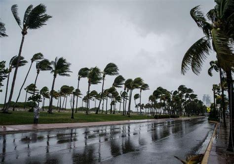
The eastern seaboard of Australia is currently grappling with the devastating effects of a powerful bomb cyclone, which has led to widespread chaos, particularly impacting Sydney Airport. The intensity of this weather system has forced the airport to scale back its operations to just one runway, resulting in significant delays and an alarming surge in flight cancellations. Millions of residents across the region are feeling the impact of this severe weather, which has been characterized by strong winds, heavy rainfall, and hazardous conditions.
In response to the extreme weather, Airservices Australia, the government body responsible for air traffic safety, made the critical decision to limit Sydney Airport’s operations to a single runway. This measure was taken in compliance with safety regulations established by the International Civil Aviation Organisation (ICAO), which outlines necessary precautions during adverse weather conditions. A spokesperson from Airservices Australia emphasized that their primary concern is the safety of the traveling public, explaining that the decision was not made lightly but was deemed necessary as weather conditions were expected to worsen.
As the Bureau of Meteorology (BOM) closely monitored the situation, Airservices Australia engaged in regular communications to assess the developing storm. Their collaboration culminated in the decision to reduce runway operations, an announcement that was made with ample warning to airline customers. Despite these proactive measures, the reality remains that flight cancellations will ultimately be determined by individual airlines.
The bomb cyclone, identified as a rapidly intensifying low-pressure system off the coast of New South Wales (NSW), has raised alarms among emergency services and local authorities. Predictions indicate that wind speeds could exceed 110 km/h, coupled with heavy rain and dangerous surf conditions. Airlines such as Virgin Australia, Jetstar, and Qantas have already begun canceling flights in anticipation of the worsening weather. Virgin Australia confirmed that many of its services, particularly those heading to Sydney and Newcastle, have been adversely affected. Their spokesperson reassured passengers that safety remains their utmost priority, and they are actively working to minimize disruptions to travel plans.
The Ground Delay Program enacted at Sydney Airport has led to fewer arrivals into the city, compounding the chaos as travelers scramble for alternate arrangements. The BOM has warned that the bomb cyclone is likely to bring extensive damage, including flash flooding and heavy rainfall that could affect large areas of NSW. As the storm progresses, emergency services are on high alert, with reports indicating that SES has responded to hundreds of incidents statewide as the system continues to intensify.
Dallas Burnes, the SES state operations manager, expressed significant concern regarding flash flooding, especially during peak commuting hours. With rainfall expected to escalate throughout the day, residents are being urged to exercise caution and avoid unnecessary travel. The peak of the storm is forecasted to occur on Wednesday, raising fears of flash flooding in vulnerable areas such as Wallis Lake near Taree on the mid-north coast of NSW. This region has already endured severe flooding earlier in the year, resulting in fatalities and extensive property damage.
Warnings have been issued for various towns across the state, including Taree, Newcastle, Gosford, Sydney, Wollongong, and Port Macquarie. The BOM has cautioned that the storm’s coastal impact could lead to dangerous beach conditions, coastal erosion, and substantial damage along the NSW coastline, particularly between Seal Bay and Batemans Bay. Burnes highlighted the potential for damaging winds, noting that gusts reaching up to 125 km/h could bring down trees, further exacerbating the hazardous conditions.
As the cyclone looms, the BOM forecasts the heaviest rainfall will strike the central coast, with totals potentially reaching 200mm. However, shifting weather patterns may redirect the most intense rainfall towards Sydney or the mid-north coast. Residents in affected regions are advised to prepare for the storm by securing loose objects and moving vehicles away from trees to mitigate damage from falling branches. Emergency services have strongly recommended that individuals stay indoors if possible, particularly in areas identified as high-risk.
SES volunteers have already been mobilized across the state, with more than a thousand individuals assisting communities affected by the storm. Authorities have underscored the importance of remaining informed through official channels and being prepared for any emergency situations that may arise.
In addition to the immediate impacts of the storm, the bomb cyclone has highlighted the vulnerability of certain regions still reeling from previous natural disasters. Areas like Taree are grappling with saturated soil from the recent May floods, increasing the risk of flash flooding due to the additional rainfall. With emergency services remaining on high alert, the ongoing situation requires close monitoring as the storm continues its path along the eastern coast.
In conclusion, the bomb cyclone wreaking havoc on the eastern seaboard of Australia has led to unprecedented disruption at Sydney Airport, with single runway operations and multiple flight cancellations adding to the travel chaos. Emergency services are actively responding to incidents across the state, with a particular emphasis on flash flooding and perilous coastal conditions. As the storm intensifies, both authorities and airlines are striving to manage its impact on the public while prioritizing safety for all those affected.


