Buffalo, New York, with its historic architecture, vibrant waterfronts, and picturesque natural landscapes, offers drone enthusiasts a spectacular range of locations to capture aerial footage. From the city’s urban charm to the untamed beauty of valleys and rivers, Buffalo has become a hidden gem for both professional drone photographers and hobbyists alike.
Lafayette Square Park: Aerial Vistas Framed by History
Nestled in the heart of downtown Buffalo, Lafayette Square Park is an epicenter of architectural and historical richness. Though no longer a traditional square, this urban green space is surrounded by the city’s tallest buildings, including the imposing Buffalo City Hall. The Soldiers and Sailors Civil War Monument, a granite column standing sentinel at the park’s core, is a particularly compelling focal point for aerial imagery.
Flying a drone here allows for stunning cinematic sweeps across historic facades and early 20th-century stonework. This area is within Class G airspace, permitting drone operations up to 400 feet, but flyers should remain vigilant of foot traffic and building proximity.
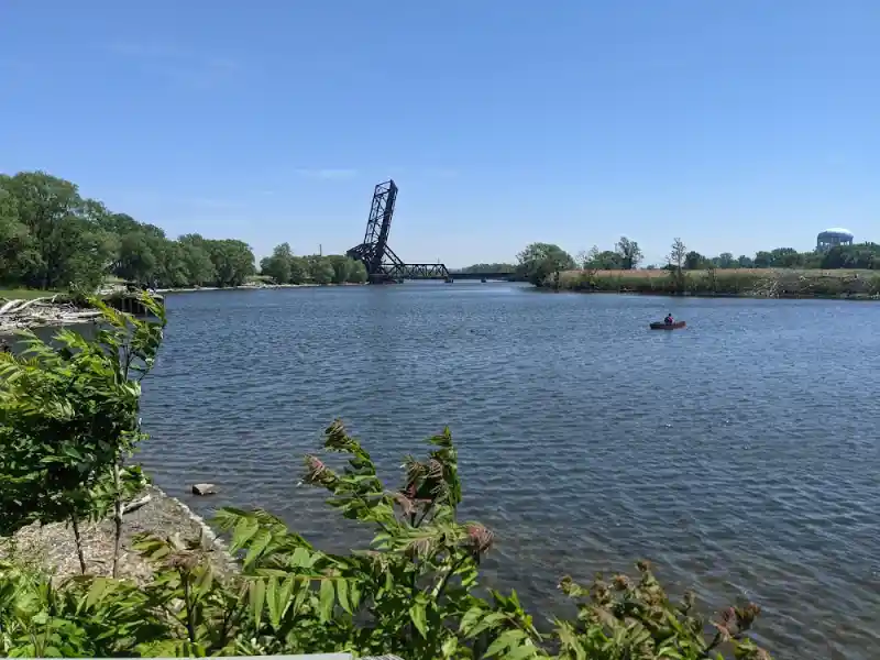
Mutual Riverfront Park: Industrial Past, Waterfront Present
At the convergence of 41 Hamburg Street and the Buffalo River, Mutual Riverfront Park stands as a testament to Buffalo’s industrial era. While relatively compact, the location offers striking visual contrasts: modern urban development alongside the raw, textured remnants of grain silos and elevators.
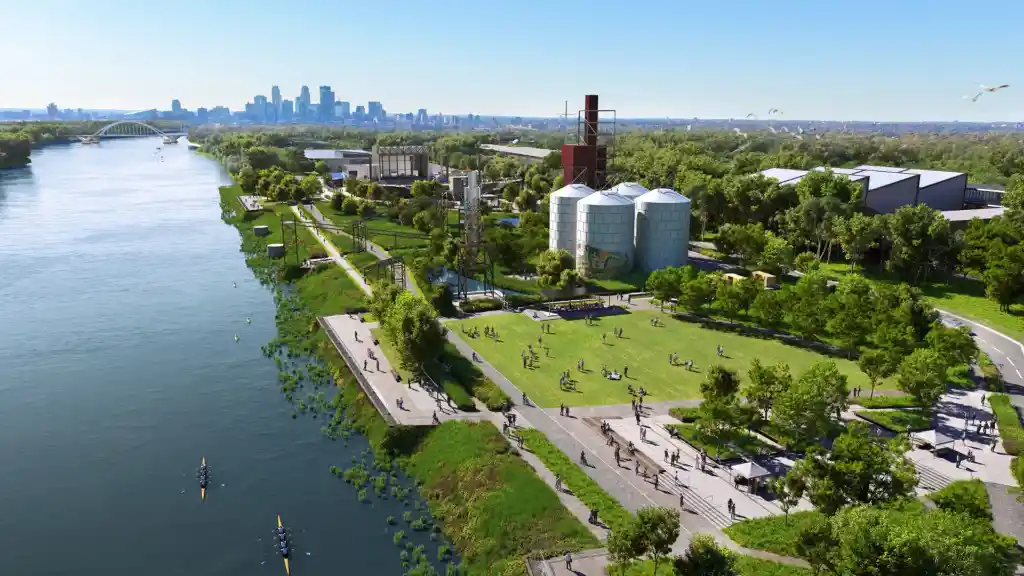
Drone footage from this vantage point captures reflections over water, kayakers slicing through the surface, and the weathered elegance of Buffalo’s riverside history. Though the park has limited space for maneuvering, it remains a favorite among drone pilots for its photogenic silos and easy public access.
Lasalle Park: Where Lake Erie Meets Industrial Heritage
Strategically positioned at the confluence of Lake Erie and the Niagara River, Lasalle Park offers open vistas perfect for expansive aerial shots. This park, a sprawling green along the water’s edge, gives drone pilots the freedom to explore wide-angle panoramas of the lake, skyline, and cargo ships passing through.
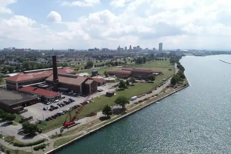
One of the most intriguing landmarks visible from the sky is the Col. Francis G. Ward Pumping Station. This red-brick architectural marvel tells a story of early 20th-century engineering, with preserved steam systems visible through overhead captures. The park’s open space and consistent winds also make it ideal for stable drone flights.
Red Jacket Riverfront Park: Echoes of Industry and Nature
Named after the Seneca orator Red Jacket, this park is steeped in industrial heritage and natural serenity. Located at 20 Smith Street, Red Jacket Riverfront Park provides one of the most historically rich landscapes for drone exploration in Buffalo. While the river now flows quietly, the remnants of Buffalo’s industrial might remain visible in the form of abandoned grain elevators, concrete factories, and rusting rail lines.
The Cargill Pool Grain Elevator and Concrete-Central Elevator stand out as photogenic monuments to a bygone era. These structures—massive, ghostly, and awe-inspiring from above—are a playground for drone videographers seeking gritty, post-industrial visuals framed by soft riverside flora.
Zoar Valley: A Wild Canvas of Cliffs and Canopies
Venturing about an hour south of Buffalo brings drone operators to the majestic expanse of Zoar Valley. With towering cliffs, deep gorges, and meandering tributaries, this area offers some of the most dynamic topography in western New York.
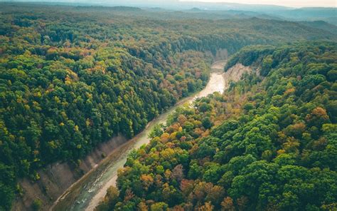
Drone footage here reveals layered rock faces, dense hardwood canopies, and seasonal rapids. Zoar Valley is particularly captivating in fall, when autumn foliage blazes across the terrain. Pilots should be especially mindful of wildlife, particularly migratory birds, which frequent the area during seasonal transitions.
The Buffalo History Museum: Elegance Above Elmwood
A flight over the Buffalo History Museum, situated at 1 Museum Court, unveils meticulously curated landscapes and a majestic neoclassical building. The museum’s Japanese Garden, framed by serene water and finely trimmed paths, adds an artistic grace to any aerial footage.
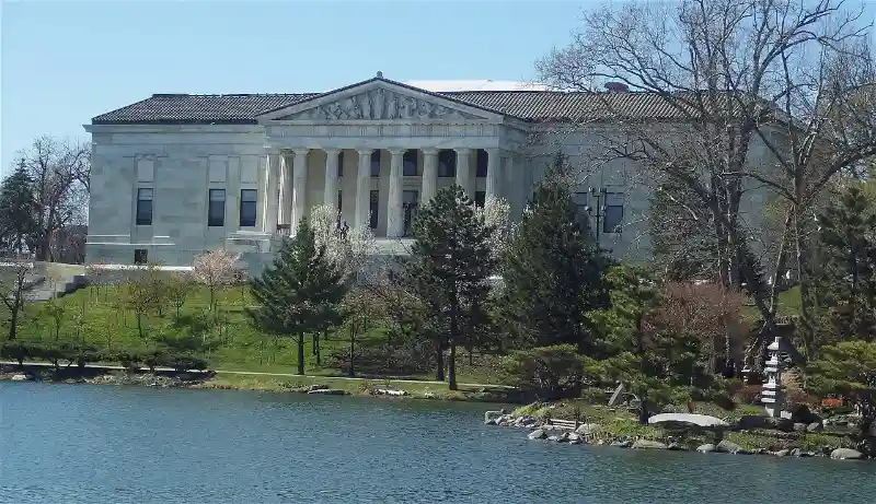
With its tranquil walking paths and open layout, the museum grounds offer a quiet sanctuary perfect for both photography and videography. While flying, it’s essential to maintain respectful distances from visitors and to avoid disrupting the peaceful environment. The juxtaposition of manicured gardens with historical architecture yields footage rich in symmetry and texture.
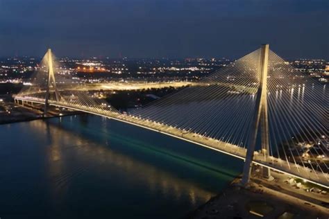
Unity Island Park: Converging Currents and Cultures
Located at 42.931122, -78.906690, Unity Island Park offers a unique blend of urban proximity and environmental diversity. Surrounded by the Niagara River, Black Rock Canal, and Buffalo’s industrial west side, Unity Island is a confluence of ecological zones and metropolitan overlays.
Drone operators can document freight traffic, fishing docks, and the Peace Bridge, a striking structure connecting the U.S. and Canada. During sunset, the golden hues illuminate the water and cast long, cinematic shadows across the landscape—ideal for dramatic aerial storytelling.
Drone Regulations and Airspace Awareness
Each of these locations falls under Class G airspace, meaning drone flights are permitted up to 400 feet. However, compliance with FAA guidelines remains paramount. Drone pilots must:
- Always maintain visual line-of-sight
- Avoid flying over people or moving vehicles
- Register their drones if above 0.55 lbs (per FAA requirements)
- Abide by local park regulations and no-fly zones
Several of Buffalo’s popular drone spots border urban areas where helicopter traffic or temporary flight restrictions may be in effect. Utilizing apps like B4UFLY or AirMap is strongly encouraged.
Seasonal Considerations for Aerial Photography
Buffalo’s four-season climate offers drone operators diverse lighting and landscapes:
- Spring provides vibrant foliage, rushing rivers, and budding gardens.
- Summer allows longer flight windows, clear skies, and recreational waterfront activity.
- Autumn ignites the region in reds, oranges, and golds, especially vivid in Zoar Valley.
- Winter, though more restrictive due to wind and snow, brings out stark contrasts and serene frozen vistas—ideal for artistic monochrome visuals.
Drone pilots should be cautious of wind shear off Lake Erie, especially near open parks like Lasalle or waterfront spaces like Mutual Riverfront Park. Proper battery management is critical in colder months when drone performance may decline.
Final Thoughts: Capturing Buffalo from the Sky
Buffalo is a city shaped by water, industry, and reinvention, and flying a drone above it reveals dimensions unseen from the ground. From the grandeur of historic buildings to the untouched beauty of rivers and valleys, Buffalo offers more than just scenic views—it offers narratives in every frame.
Each flight over this revitalized city is an opportunity to preserve its complex past, resilient present, and aspiring future. Whether you’re documenting nature’s geometry in Zoar Valley or capturing the urban sprawl from Lafayette Square, Buffalo invites you to explore, elevate, and create.
So pack your batteries, update your firmware, and take to the skies—Buffalo is ready for its close-up.


