
Understanding wind gusts is essential for anyone involved in aviation, sailing, or any outdoor activity where wind plays a critical role. Accurately interpreting wind data not only enhances safety but also ensures optimal performance in challenging environments.
What Are Wind Gusts?
Wind gusts refer to sudden, brief increases in wind speed that typically last for a few seconds. Unlike sustained winds, which are measured over a longer period, gusts represent rapid fluctuations, often influenced by localized atmospheric conditions. In aviation, understanding gusts is vital, as they can affect everything from takeoff and landing to in-flight stability.
Decoding a Typical Wind Gust Report
When reading a METAR (Meteorological Aerodrome Report), you might encounter a code like “33016G25KT”. To break this down:
- 330 indicates the wind is coming from 330 degrees (roughly northwest).
- 16 represents the sustained wind speed in knots.
- G25 means gusts up to 25 knots.
- KT stands for knots, the standard unit for wind speed in aviation.
Thus, “33016G25KT” means the wind is blowing from 330 degrees at 16 knots, with gusts reaching 25 knots.
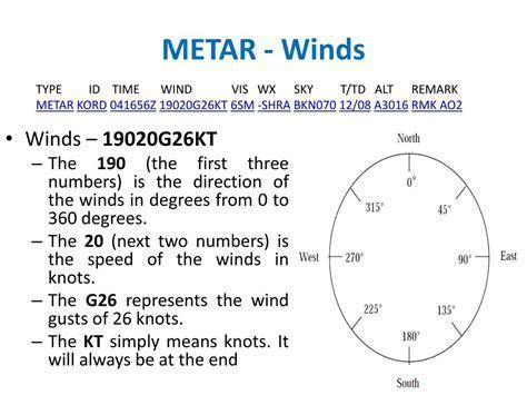
It is important to note that gusts are not additive. The gust speed is the maximum observed speed, not the sustained speed plus the gust value. Therefore, in the example, the wind can peak at 25 knots, not 41 knots (16 + 25).
Understanding Wind Direction During Gusts
Generally, gusts are assumed to occur in the same direction as the sustained wind. However, if the wind direction varies significantly, this will be reported. For instance, if the wind shifts more than 60 degrees, the METAR might state something like “180V270”, meaning the wind is varying between 180 and 270 degrees.
In spoken weather reports, pilots might hear, “Winds 330 at 16, gusting to 25, varying between 300 and 360 degrees.” Understanding these fluctuations is vital for flight planning, especially when approaching or departing an airport.
How Are Wind Gusts Measured?
The measurement of gusts depends on the environment:
- METAR Reports: Based on a 10-minute average for sustained winds, with gusts recorded when wind speed exceeds the mean by at least 10 knots.
- Control Towers: Some towers display both instantaneous and mean wind values. For example, places like Aspen may prioritize instantaneous readings due to terrain-induced wind variability.
Officially, however, METAR wind information is based on the 10-minute mean wind speed, providing a standardized approach to reporting across global aviation networks.
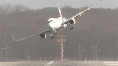
Impact of Wind Gusts on Flight Operations
Wind gusts can have profound effects on aircraft performance. During takeoff, a sudden gust can momentarily increase lift, potentially causing premature liftoff. On landing, a gust can either lift the aircraft unexpectedly or cause destabilization on final approach. Crosswind gusts, in particular, present substantial challenges, requiring skilled handling and sometimes necessitating go-arounds or diversions.
Gust factors are often included in takeoff and landing calculations. Pilots might adjust their approach speeds by adding half the gust factor to their standard approach speed to maintain better control during unexpected gusts.
Variable Winds and Reporting Variations
When a METAR reports a wide range of wind directions, it indicates high variability, often seen near weather fronts or in mountainous regions. A METAR might display “VRB” for very light and variable winds. In cases where the variability is between two specified directions, such as “300V360”, pilots must prepare for fluctuating crosswind components.
Understanding these nuances is crucial for flight safety, particularly when choosing the appropriate runway. Choosing a runway aligned closer to the mean wind direction can significantly reduce crosswind challenges.
Key Points to Remember When Reading Wind Gusts
- Gust Speed Is Absolute: It is not added to the sustained wind speed but represents the peak observed.
- Direction Typically Remains Constant: Unless significant variability is indicated.
- Official Reporting Is Based on Averages: Instantaneous values may be visible to tower personnel but are not generally issued in official reports.
- Pilots Must Adjust Techniques: Especially during takeoff and landing to accommodate gusty conditions.
Practical Tips for Handling Gusty Winds
We recommend the following strategies for pilots dealing with gusty winds:
- Monitor ATIS/ASOS Broadcasts Carefully: Pay close attention to updates, as wind conditions can change rapidly.
- Adjust Approach Speeds: Typically, add half the gust factor to the final approach speed.
- Plan for Go-Arounds: Always be mentally prepared to execute a missed approach if gusts destabilize the landing.
- Use Proper Crosswind Techniques: Employ crab or sideslip methods depending on aircraft type and pilot preference.
- Stay Updated with METARs: Constantly monitor new METARs during pre-flight and inflight planning stages.
Wind Gusts in Different Weather Conditions
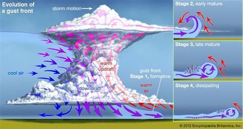
Wind gusts occur most frequently in association with cold fronts, thunderstorms, and mountainous terrain. Convective activity can produce extreme gusts, sometimes resulting in dangerous wind shear near the ground. Pilots operating in such conditions must exercise heightened vigilance, review weather radar data, and be prepared for sudden wind shifts.
In clear air conditions, gusts are less intense but can still pose operational challenges, especially in desert regions or in coastal zones where sea breezes interact with the prevailing winds.
Advanced Wind Reading: Beyond METARs
Professional aviators often supplement METARs with additional sources like:
- TAFs (Terminal Aerodrome Forecasts): Offering forecasts of winds and gusts over a 24 to 30-hour period.
- Pilot Reports (PIREPs): Providing real-time observations from other pilots.
- Radar and Satellite Imagery: Assisting in detecting storm systems capable of producing strong gusts.
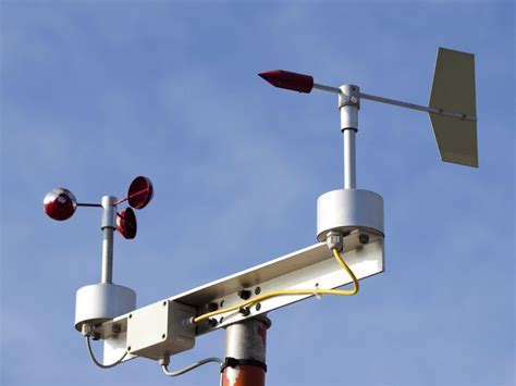
- AWOS/ASOS Real-Time Systems: Automated weather stations offering continuous wind updates.
Incorporating these multiple data sources allows for a more comprehensive understanding of wind conditions and enhances situational awareness.
Conclusion: Mastering the Art of Reading Wind Gusts
Mastering the skill of reading and interpreting wind gust information is not just a technical exercise; it is a cornerstone of safe and efficient flight operations. From decoding METARs to adjusting flight techniques, pilots who take the time to fully understand wind gust dynamics are better equipped to handle the surprises that nature inevitably presents. With the right knowledge and preparation, even the most challenging gusty conditions can be managed with confidence and precision.


