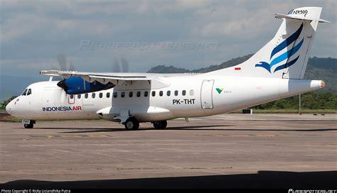
An Indonesian government-operated turboprop aircraft carrying 11 people has crashed near Makassar, raising urgent questions about flight procedures, terrain awareness, and weather conditions in one of Southeast Asia’s most complex aviation environments. The aircraft, an ATR 42-500 operated by Indonesia Air on behalf of the Ministry of Marine Affairs and Fisheries, went down while approaching Sultan Hasanuddin International Airport, ending a routine domestic flight in catastrophe.
The flight departed Yogyakarta in the morning and had been airborne for more than three hours before losing contact. According to early official information, the aircraft disappeared from radar at low altitude while flying over the ocean northeast of Makassar, shortly before it was expected to align with its final approach. Onboard were eight crew members and three passengers, all of whom were conducting official duties related to fisheries monitoring.
Initial reports indicate that the turboprop was navigating challenging weather conditions as it descended toward the airport. Thick cloud cover and fog were reported across the region, reducing visibility and complicating visual references during a critical phase of flight. Air traffic controllers reportedly noticed anomalies in the aircraft’s positioning moments before communication was lost.
Flight Data Reveals Final Moments Before Disappearance
Tracking data from Flightradar24 provides a detailed snapshot of the aircraft’s final minutes. The last recorded signal was received at 04:20 UTC, approximately 20 kilometers northeast of Makassar Airport. At that time, the ATR 42 was traveling at a ground speed of 221 knots and flying at an altitude of 5,150 feet. Fifteen minutes earlier, it had been recorded at 6,150 feet over the Pabbiring Islands, indicating a gradual descent consistent with approach procedures.
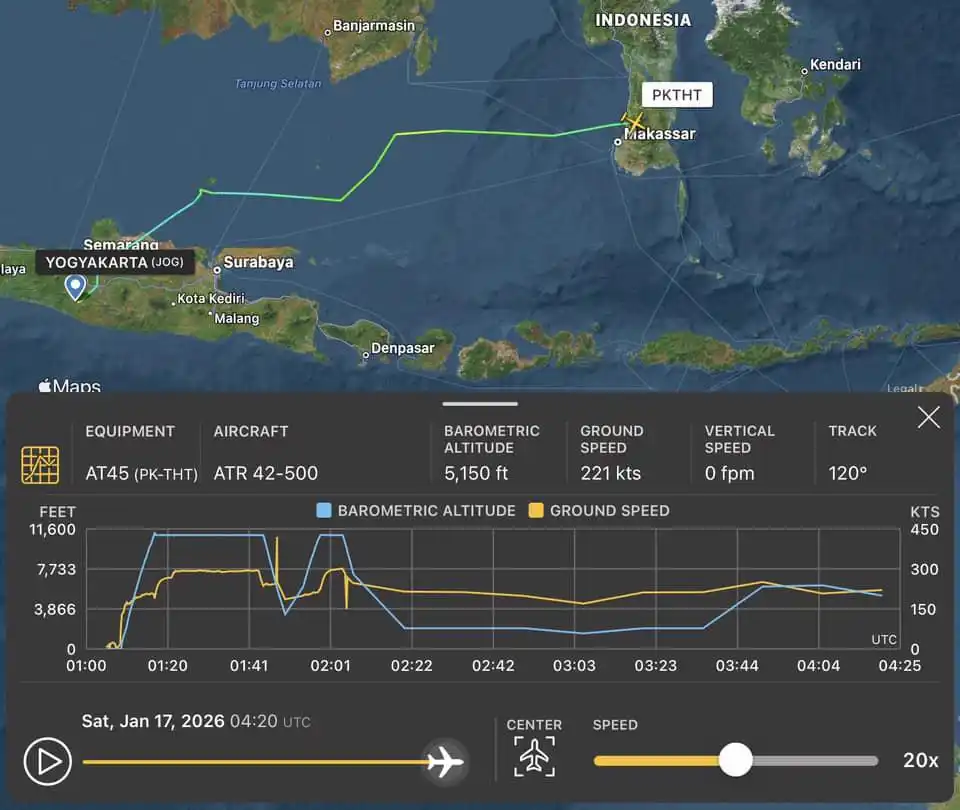
Despite this, the aircraft was reportedly not aligned with the correct approach path. Indonesian aviation officials later confirmed that Makassar air traffic control had issued multiple instructions to reposition the plane for Runway 21. These corrections suggest that the aircraft may have deviated laterally or vertically from its intended track, a situation that becomes especially dangerous in regions surrounded by rising terrain.
Crash Site Located in Mountainous National Park
Search authorities have identified the crash location within Bantimurung–Bulusaraung National Park, a mountainous and forested area north of Makassar. The park is known for steep limestone formations, dense vegetation, and rapidly changing weather conditions. Local villagers were among the first to report signs of the crash, sharing images that showed burning wreckage scattered across rugged slopes.
The presence of thick fog in videos taken shortly after the accident has become a central focus of early analysis. Visibility appears severely limited, reinforcing concerns that the aircraft may have been flying in instrument meteorological conditions while near high ground. Authorities have not yet confirmed casualties, but the intensity of the impact and fire has raised grave concerns.
Air Traffic Control Instructions and Lost Communication
According to Indonesia’s Directorate General of Civil Aviation, Makassar ATC first instructed the aircraft to prepare for an approach to Runway 21 at approximately 04:23 UTC. Controllers observed that the ATR 42 did not follow the expected approach corridor and issued additional vectors to reposition it safely. Shortly after these final instructions, radio contact was lost.
An emergency was declared almost immediately, triggering coordination between aviation authorities, search and rescue agencies, and local governments. A Notice to Airmen was prepared as part of standard protocol, while ground teams and aerial assets were dispatched toward the estimated crash area near Leang-Leang, between the Maros and Pangkep regencies.

Controlled Flight Into Terrain a Key Early Theory
Aviation analysts are increasingly considering Controlled Flight Into Terrain as a possible explanation. CFIT accidents occur when an airworthy aircraft, under pilot control, unintentionally flies into terrain due to loss of situational awareness. Factors often include poor visibility, high workload during approach, navigation errors, or misinterpretation of instruments.
Makassar’s airport is surrounded by elevated terrain that requires strict adherence to published approach procedures. While modern turboprops like the ATR 42 are equipped for instrument approaches in low visibility, any deviation from ATC guidance significantly increases risk. The confirmed presence of dense fog, combined with an incorrect approach path, aligns with known CFIT risk patterns.
Broader Context of Indonesian Aviation Safety
Indonesia operates one of Asia’s largest and fastest-growing aviation markets, connecting thousands of islands across vast distances. This geographic complexity, combined with challenging weather and terrain, places heavy demands on flight crews and air traffic services. Despite improvements in oversight and training, the country has experienced numerous serious aviation accidents over the decades.
High-profile incidents in recent years, including the Sriwijaya Air Boeing 737-500 crash in 2021 and the Lion Air 737 MAX disaster in 2018, continue to shape public perception and regulatory focus. Each new accident renews scrutiny on operational discipline, infrastructure investment, and safety culture across the sector.
As search and rescue operations continue in difficult conditions, investigators will work to reconstruct the aircraft’s final flight path, cockpit decisions, and environmental factors. The findings are expected to influence future approach procedures and risk mitigation strategies at terrain-challenged airports like Makassar, as Indonesia seeks to prevent another tragedy of this scale.


