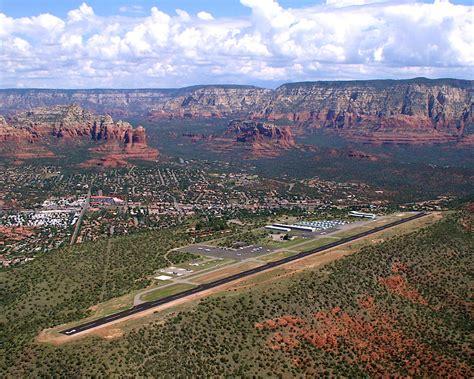
Sedona Airport, located at 34°51′00″N 111°47′24″W, stands as one of Arizona’s most visually striking aviation facilities, not merely for its functionality but for its astonishing geographic setting. Nestled atop a mesa 4,830 feet above sea level, this public-use airport commands a sweeping view over the city of Sedona and the majestic Red Rock formations that define the region’s unique geological identity.
The Mesa in the Sky: Sedona Airport’s Geographic Allure
What sets Sedona Airport (IATA: SDX, FAA LID: SEZ) apart is its rare positioning on a flat-topped mesa—earning it the evocative label of a “tabletop runway.” This elevated terrain creates an illusion often witnessed by visitors in downtown Sedona: aircraft seemingly disappearing into the mountains mid-flight. This topographic peculiarity is not only captivating but also adds complexity to pilot navigation and approach patterns.
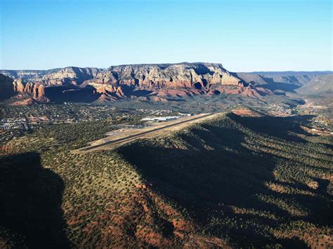
The airport lies roughly 2 miles southwest of Sedona’s central business district and spans 220 acres. With one primary asphalt runway (3/21), measuring 5,132 feet, and a single helipad (H1) made of concrete, Sedona Airport caters primarily to general aviation, serving over 35,000 aircraft operations annually as of 2022. Its non-towered status requires pilots to communicate effectively using standard radio frequencies when entering or exiting its airspace.
A Rich Aviation Legacy Since 1955
Sedona Airport was first established in 1955, during a time when the airstrip was little more than a cleared stretch of desert, unpaved and exposed to local wildlife. Early pilots risked encounters with animals like coyotes, which roamed freely across the landing area. It wasn’t until 1957 that the runway was paved, significantly improving safety and expanding accessibility.
Throughout the 1980s and 1990s, Sedona Airport enjoyed a modest but steady rise in popularity. Air Sedona, founded by Jack Seeley in 1981, offered scheduled flights to Phoenix Sky Harbor, Las Vegas, and even the Grand Canyon. By 1990, the airport had matured into a reliable regional hub, though its runway limitations prevented it from accommodating larger commercial jets such as the Boeing 737.
Other carriers, like Desert Pacific Airlines and Scenic Airlines, briefly operated flights from Sedona. However, due to the short runway and lack of terminal infrastructure for commercial aviation, such services were eventually discontinued, with Scenic Airlines pulling out in April 1997.
Strategic Operations and Aircraft Diversity
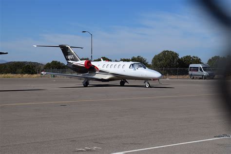
Despite its limitations for large commercial aircraft, Sedona Airport has become a hotspot for business aviation. The location attracts a range of corporate jets, private aircraft, and sightseeing helicopters. Aircraft types frequently seen here include Beechcraft King Air, Cessna Citation jets, and a variety of rotorcraft used for aerial tours over Red Rock country.
The airfield houses approximately 63 based aircraft, and its relatively high elevation demands precise aircraft performance management—especially under hot and high conditions that can impact engine thrust and lift. Pilots must also be vigilant for downdrafts and crosswinds, made more unpredictable by the surrounding terrain.
Cultural and Digital Footprint
The airport is more than just a transportation node—it also holds cultural and digital relevance. It is featured prominently in Microsoft Flight Simulator, where it serves as one of the handcrafted, high-detail airports in the game. The simulator’s digital replication of Sedona Airport reflects its popularity among flight training programs and virtual aviation enthusiasts, offering realistic taxiway geometry and elevation modeling that mirrors the challenges of the real-world location.
Safety and Accidents: A Record of Risk
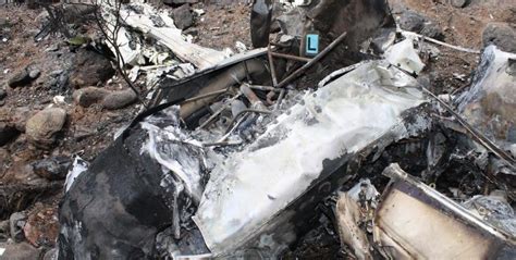
Operating on a mesa inherently adds a layer of operational risk. Over the years, several incidents have underscored the unique challenges posed by Sedona’s airfield. On April 13, 2003, a Beechcraft Bonanza collided with terrain after hitting a fence on the approach to runway 21, tragically killing all three onboard.
Another high-profile accident occurred on July 26, 2012, when two-time Olympic distance runner Pat Porter, his son, and a family friend died after a Beechcraft Duke crashed shortly after takeoff. More recently, on April 25, 2021, a Cessna 182 Skylane crashed during operations, resulting in injuries but no fatalities.
Sedona’s Economic and Tourism Role
Although it is not a commercial hub, Sedona Airport plays a critical role in the city’s tourism economy. The airfield is a major gateway for high-net-worth individuals, aerial tour companies, and adventure travelers seeking quick access to Sedona’s landscape without navigating winding desert roads.
The airport supports helicopter tour operators, small charters, and skydiving services, and has become an ideal starting point for scenic aerial photography and geological surveys. Its visitor-friendly facilities include a restaurant with panoramic views and an overlook point that serves as a public attraction.
Governance and Infrastructure
Owned by Yavapai County, the airport is managed in collaboration with the Sedona-Oak Creek Airport Authority, which oversees operations, safety protocols, and ongoing maintenance. Infrastructure upgrades are periodically implemented, often in response to increased traffic or revised FAA standards.
While its elevation and terrain limit physical expansion, master planning documents have guided airport development since the 1990s. Emphasis remains on maintaining the airport’s general aviation orientation while improving pilot amenities, runway safety areas, and environmental impact mitigation.
Navigational and Technical Specifications
- ICAO Code: KSEZ
- IATA Code: SDX
- Runway: 3/21 (5,132 ft, asphalt surface)
- Helipad: H1 (50 ft, concrete surface)
- Elevation: 4,830 ft (1,472 meters)
- Total Aircraft Operations (2022): 35,000
- Based Aircraft: 63
- Towered?: No (Non-towered)
This setup places the responsibility for traffic separation on pilots’ situational awareness, aided by UNICOM frequency coordination. Flight planning requires heightened vigilance due to thermal updrafts, sudden windshear, and limited visual cues during dusk and dawn.
Conclusion: A Boutique Aviation Jewel in the Southwest
Sedona Airport remains a rare confluence of natural beauty and aviation utility, uniquely serving the needs of regional travelers and private pilots while posing exhilarating challenges from a flight operations perspective. Whether it is experienced firsthand in a cockpit or simulated from a virtual console, KSEZ exemplifies the harmonious balance between aviation engineering and environmental majesty. Its enduring legacy, from humble 1950s beginnings to digital stardom in the 21st century, cements Sedona Airport as not just an airfield—but an icon.


: The Definitive Guide to Arizona's Busiest Travel Hub")


")
