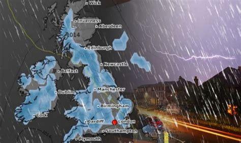
The United Kingdom is on high alert this weekend as a volatile mix of weather systems brings with it unrelenting rainfall, intense thunderstorms, and flood risks that have prompted a fresh warning from the Met Office. Citizens are being urged to reconsider travel plans, especially in the most affected regions, as the country prepares to endure one of its most severe weather episodes in recent months.
The Met Office’s latest advisory comes after days of turbulent conditions, but the forecast ahead marks a significant escalation. With multiple yellow and amber warnings issued for large swathes of the country, authorities are now preparing for widespread disruption to transport, infrastructure, and daily life.
Torrential Rainfall Set to Engulf England, Wales, and Scotland
The current weather system is being driven by a deep Atlantic low-pressure front dragging heavy rainbands across the UK from west to east. According to meteorologists, areas in southwestern England, South Wales, and parts of southern Scotland are likely to bear the brunt of the deluge.
In some regions, projected rainfall totals may exceed 70mm within 24 hours, an amount comparable to an entire month’s worth of precipitation. The impact will be compounded by already saturated ground conditions due to persistent rain throughout the early summer.
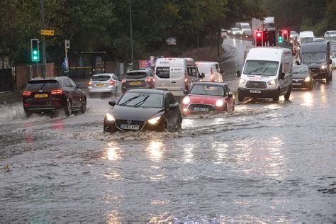
Hydrologists are warning that this combination will elevate flood risks, particularly in urban zones with poor drainage systems and low-lying countryside. Flash floods are likely to result in road closures, delayed or cancelled train services, and temporary evacuation orders in vulnerable towns.
Met Office Issues Thunderstorm Alerts Across the UK
In tandem with the soaking rain, the UK will face multiple bands of thunderstorms, predicted to roll in from the southwest and sweep northeastward over the weekend. The Met Office has placed amber thunderstorm warnings across much of central and eastern England, as well as parts of the Midlands.
These thunderstorms are expected to produce:
- Frequent lightning
- Hailstones up to 2cm in diameter
- Localized wind gusts exceeding 60mph
While thunderstorms are not uncommon in the UK summer, the intensity of this system has meteorologists concerned. “We’re looking at supercell-like structures forming, which is very rare for this latitude,” said Dr. Eleanor Henson, a senior climatologist at the University of Reading.
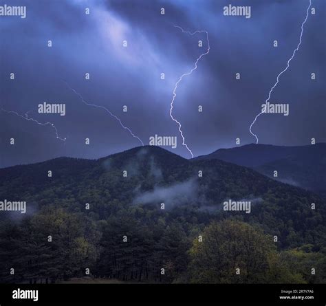
Electrical storms will also bring disruption to air traffic control, raising the potential for flight delays and diversions, particularly from airports like Gatwick, Luton, and Birmingham International. Travellers are strongly encouraged to check their flight status frequently and allow for contingencies.
Rail, Road, and Air Travel Face Significant Disruption
National Rail services have already announced possible line closures and service suspensions along vulnerable flood routes, particularly in western England and southern Wales. Network Rail has positioned emergency response units and pumping teams in anticipation of waterlogged tracks.
Meanwhile, the UK’s motorway network is expected to suffer heavy delays, especially the M4, M5, M6, and M25 corridors, which are likely to be inundated or slowed by surface water hazards and reduced visibility. Motorists have been cautioned to avoid travel unless absolutely necessary.
At Heathrow Airport, where operations are frequently impacted by adverse weather, a spokesperson has confirmed that contingency plans are in place, including aircraft rerouting protocols and ground crew readiness for flash flooding and lightning alerts.
Public Safety Urged as Flash Flooding Risks Increase
The Environment Agency has issued multiple flood alerts across England, warning of rivers likely to burst their banks. Critical areas under surveillance include the River Severn, River Trent, and Thames tributaries. Residents in flood-prone zones are being advised to prepare emergency kits, secure important documents, and monitor local authority announcements.
Schools and community centres in high-risk areas may be converted into emergency shelters. Local councils are coordinating with emergency services to provide rapid response support, including sandbag distribution and power outage management.
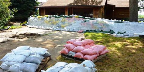
Officials from the Department for Environment, Food and Rural Affairs (DEFRA) have emphasized the role of community awareness in preventing fatalities. “We’re asking people not to underestimate the power of floodwaters. Stay away from swollen rivers, even if they appear passable,” urged DEFRA spokesperson Jamie Colling.
Weekend Events Cancelled Amid Safety Concerns
The timing of the weather disruption could not be worse for many across the country, as major weekend events including music festivals, open-air markets, and sporting matches face cancellations. Notably, the Manchester Street Food Festival and the Norfolk Garden Show have already announced postponements due to severe weather forecasts.
Football matches in League One and lower divisions are also being reviewed by local councils and sports associations. Safety for fans, players, and staff remains a top priority, with many venues opting to call off games early to avoid chaos on matchday.
This has hit local economies hard, particularly in tourist-dependent towns where events like these attract thousands of visitors. Hotel bookings have been cancelled, and small businesses relying on weekend footfall have expressed concern about lost revenue.
Experts Tie Weather Volatility to Climate Change Patterns
Scientists continue to link the increasing severity and frequency of extreme weather events in the UK to shifts in global climate systems. According to the Met Office Hadley Centre, rising sea surface temperatures and atmospheric instability are contributing to the intensification of storm cells over the British Isles.
Dr. Melissa Forrester, a climate dynamics specialist at Exeter University, explained, “What we’re witnessing is not just freak weather. This is a trend—more moisture in the air, more heat energy, more convective potential. These storms are becoming the new normal.”
The UK government has pledged to increase funding for flood defenses and invest in adaptive infrastructure, but campaigners argue that efforts are still lagging behind the pace of change. Many local councils remain under-resourced when it comes to managing climate-linked emergencies.
The Forecast for Next Week: Relief or More Trouble?
Looking ahead, the latest model projections suggest that conditions may moderate by mid-next week, but not before another round of low-pressure systems pushes through from the west. Temperatures will remain slightly below average, hovering around 14–17°C, with a lingering chance of showers persisting through Thursday.
However, meteorologists caution that the atmosphere remains unstable, and a return to storm conditions later in the week cannot be ruled out. Those planning travel or outdoor activities beyond the weekend are advised to continue monitoring updates from the Met Office and local weather services.
Final Word: Stay Alert, Stay Safe, and Stay Put
This weekend’s severe weather event underscores a growing reality for the UK: weather unpredictability is now a fact of life. Whether you’re planning a countryside getaway, a city day trip, or attending a large event, the clear advice from emergency authorities and meteorologists alike is simple—do not travel this weekend unless absolutely essential.
Check your local council’s emergency response notices, monitor the Met Office’s live radar feeds, and remain indoors during periods of lightning or heavy rain. If travel is unavoidable, ensure your vehicle is equipped with emergency supplies, and allow significantly more time for your journey.
As the nation braces for this intense onslaught of rain and thunder, personal caution and community vigilance will be critical to avoiding unnecessary tragedy. The storm will pass—but how we respond now will shape the impact it leaves behind.


