Class E airspace is the most prevalent type of controlled airspace in the United States, yet its complexity often makes it one of the most misunderstood. Unlike more rigidly defined Class B or C zones, Class E is nuanced in its design and purpose. It is designed to ensure safe separation for Instrument Flight Rules (IFR) traffic, while simultaneously accommodating Visual Flight Rules (VFR) operations without the burden of continuous communication with Air Traffic Control (ATC). Its subtle boundaries, varying entry altitudes, and flexible transition shapes serve both functional and safety-driven purposes across a diverse array of aviation scenarios.
At its core, Class E airspace is controlled, but it is not uniformly restrictive. IFR aircraft within Class E airspace must receive ATC clearance and remain under control, a necessity to ensure route precision and obstacle avoidance. VFR aircraft, by contrast, are not required to communicate with ATC when operating in most Class E zones. This dual system reflects a key principle in airspace management: balancing freedom of operation for VFR pilots with the structure and separation essential to IFR operations.
Controlled But Not Confined: The Nature of Class E Airspace
To understand why Class E is classified as controlled airspace, we must consider its primary function. This airspace is critical for enabling safe IFR navigation between Class A and terminal environments. Whether a pilot is operating near the surface in a remote area or transitioning between busy flight corridors, Class E ensures IFR aircraft remain under continuous ATC oversight. However, unlike Class B or C, Class E does not require VFR pilots to check in unless otherwise specified.
This structured yet permissive approach exists because Class E supports both enroute and terminal operations. An IFR aircraft descending through cloud cover on approach must be protected from non-communicating VFR traffic that may be climbing nearby. In such cases, VFR weather minimums are enforced to create the “see and avoid” buffer zone that enhances mutual safety.
Weather Minimums: The Key to Visual Separation
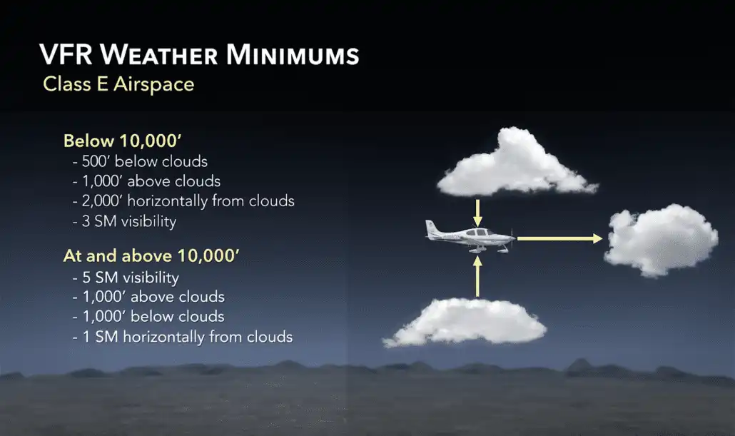
Weather minimums within Class E airspace are tailored to ensure adequate visibility for VFR pilots and vertical/horizontal separation from IFR aircraft. Below 10,000 feet Mean Sea Level (MSL), VFR weather minimums are set at 3 statute miles visibility, 500 feet below, 1,000 feet above, and 2,000 feet horizontally from clouds. These rules give both VFR and IFR pilots enough space to visually identify and avoid each other.
Once above 10,000 feet MSL, the minimums increase to 5 statute miles visibility, with cloud clearance expanding to 1,000 feet below, 1,000 feet above, and 1 statute mile horizontally. This adjustment coincides with FAR 91.117, which limits aircraft speeds below 10,000 feet to 250 knots. Above that threshold, faster-moving traffic demands longer reaction times and greater separation.
Where Does Class E Begin? Understanding Altitudes and Boundaries
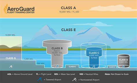
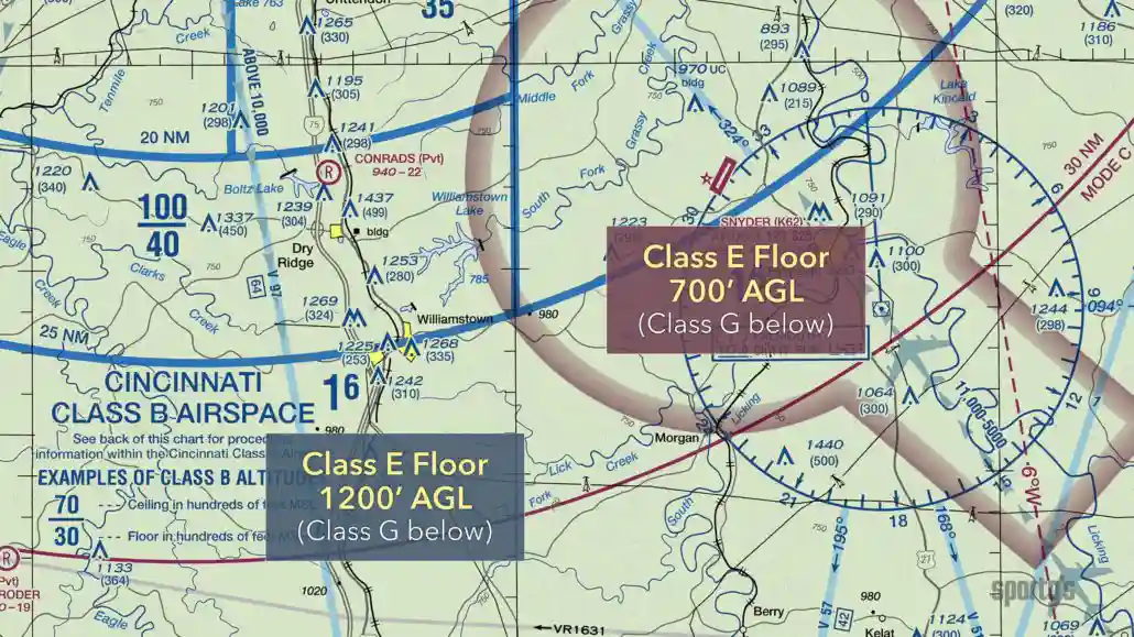
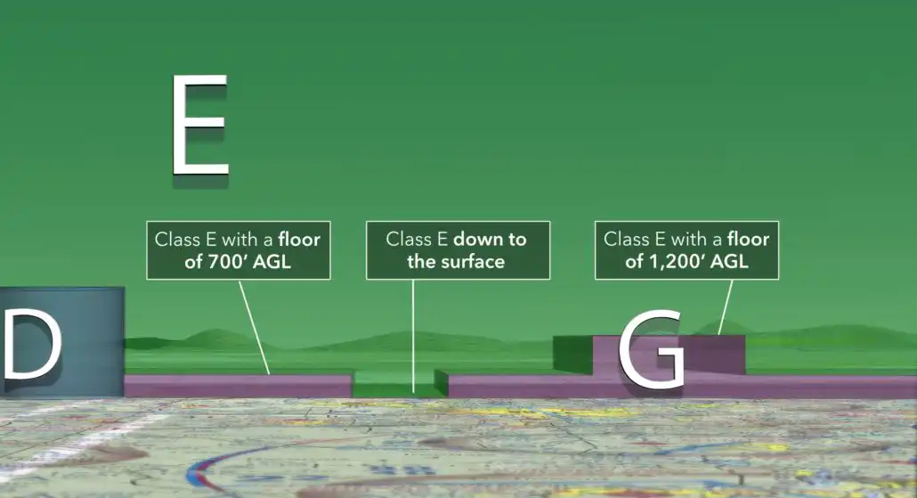
Determining where Class E airspace starts can initially appear arbitrary. In reality, its floor is carefully defined based on traffic density, terrain, and navigational requirements. Across much of the continental United States, Class E begins at 1,200 feet Above Ground Level (AGL)—a layer known as enroute Class E airspace. It is marked on sectional charts with fuzzy blue boundaries, indicating the controlled airspace used to connect terminal environments with Class A.
In busier or more geographically complex regions, transition areas are established where Class E starts at 700 feet AGL. These zones are commonly found near airports and are highlighted by broad magenta lines, fuzzy on the inner side. These lower transition floors allow IFR aircraft to enter a controlled environment earlier on approach or remain in contact with ATC longer during departure.
Why 700 Feet? The Role of Transition Areas
At first glance, it might seem illogical to control airspace down to 700 feet in areas far from the airport. However, this design serves a critical safety purpose in Marginal VFR (MVFR) conditions. In reduced visibility, a VFR aircraft could be flying just a few hundred feet below an IFR plane in cloud. By dropping Class E’s floor to 700 feet, ATC ensures a safety buffer between controlled and uncontrolled operations.
Moreover, transition areas are not uniformly shaped. Depending on terrain, population density, and instrument procedures, these Class E extensions may adopt rectangular protrusions or irregular boundaries. These shapes are often dictated by the path of IFR approaches or departures, extending outwards to accommodate aircraft transitioning to and from navigation points such as VORs.
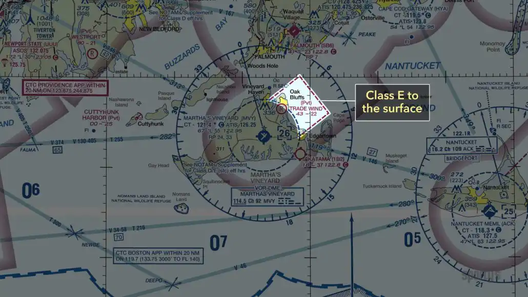
Surface-Based Class E: A Resemblance to Class D
Some Class E airspace descends all the way to the surface. These areas are essential in locations lacking control towers but still offering precision instrument approaches. On sectional charts, Class E surface areas resemble Class D zones but are marked with magenta borders instead of blue. These zones are integral for airports without towered facilities but with significant IFR traffic.
A typical surface-based Class E area is surrounded by a larger transition zone. The airspace design resembles the tiered “wedding cake” of Class C or B but scaled back to reflect the lower intensity of operations. Nonetheless, surface Class E areas require a functioning weather station and ground-based ATC communications capability, whether through a center, approach control, or even Flight Service.
Extensions and Terrain Considerations: Tailoring Class E to the Environment
One of the most complex aspects of Class E design is the adaptation to terrain. In mountainous regions or areas with rising topography, Class E must stretch and deform to maintain safety margins. This results in elongated transition zones, asymmetric extensions, and customized airspace blocks that follow the logic of instrument procedure paths.
Take, for example, the case of Summersville Airport (KSXL). Its surrounding Class E airspace includes asymmetric extensions aligned with approach and departure paths. These are longer in the northeast quadrant due to rising terrain, ensuring aircraft have sufficient climb performance to remain in protected space. Once we recognize that airspace is shaped not just by traffic but also by geography and procedure design, the apparent randomness of Class E boundaries reveals its underlying precision.
The Logic Behind the Layers: Bringing It All Together
The most important takeaway when analyzing Class E airspace is understanding its purpose-driven architecture. It is not arbitrary; rather, it is a result of calculated trade-offs between freedom and control, efficiency and safety. IFR traffic remains under ATC guidance throughout its enroute and terminal phases, while VFR traffic is offered greater autonomy—provided weather minimums ensure visual separation.
From the 14,500-foot enroute layers in sparse regions to surface-based zones around busy non-towered airports, Class E airspace represents a continuum of control. It fills the gaps between Classes A, B, C, and D, while adapting to unique local demands. For both student pilots and experienced aviators, decoding the Class E structure transforms confusion into confidence.
Understanding this airspace begins not with memorization, but with asking the right questions: Where are the IFR routes? What does the terrain demand? How are aircraft arriving or departing? Class E responds to these needs with subtle, intelligent design. By internalizing its logic, we become not only better pilots—but safer ones.


")

")


