Definition
Automated cloud base height and horizontal visibility measurements use data collected from unattended sensors. This technology simplifies weather observation and enhances accuracy.
Cloud Base Recording
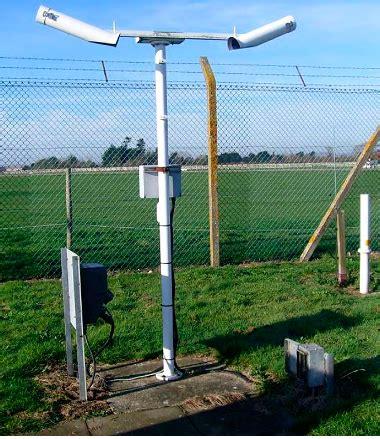
Most cloud base recorders, often called ceilometers, utilize LIDAR (Light Detection and Ranging) technology. They send out a pulsed diode laser in a vertical direction. When this laser hits a cloud or other particles, it reflects back. The time it takes for the light to return helps determine the height of the lowest cloud base, and some advanced instruments can measure additional cloud bases too. The laser’s wavelength is similar to the size of common aerosols, making it effective for this purpose. Some recorders can tilt about 10° from vertical, which protects against precipitation interference. A tilt angle sensor adjusts the measurement back to the vertical. Additionally, features like heating and air blowers keep the recorder’s window clean and dry. LIDAR-based recorders can detect cloud bases over 20,000 feet, often exceeding that range. Besides calculating cloud base heights, many recorders estimate cloud cover using historical data processing.
Optical Drum Recorders
Before LIDAR, optical drum recorders were widely used. These devices had a transmitter that sent a modulated light beam at an angle to the vertical, rotating from 8° to 85° and back within a minute. A separate receiver, placed at a known distance, detected light only in the vertical direction. By measuring interruptions in the light beam caused by clouds, the system calculated cloud base height through triangulation. In the UK, these recorders served as aids for human observations rather than standalone tools.
Advantages and Disadvantages of Cloud Base Recorders
-
Advantages: Improved accuracy, especially at night; consistent reporting.
-
Disadvantages: Delay in recording real-time conditions; potential misreporting of slow-moving clouds; false detections due to other atmospheric features; difficulties in detecting cloud bases when the sky is obscured.
Visibility Measurement
A visibility meter, positioned at the observation site, consists of a transmitter and receiver. It measures visibility using the extinction coefficient of transmitted light, automatically converting this data into visibility figures. This conforms to the World Meteorological Organisation (WMO) definition of Meteorological Optical Range (MOR). MOR focuses on atmospheric transparency along a path during daylight, defining the distance light travels before its brightness drops to 5% of its original value. While automated measurements are highly accurate, they reflect the local conditions around the instrument rather than broader visibility, which trained observers assess.
The forward scatter system is the most common method for measuring the extinction coefficient. A xenon strobe transmitter sends light into the air, and a photo diode receiver detects the amount of light received. The presence of particles like water, dust, or smoke increases scattering, allowing this method to closely mimic human visibility perception. Visibility measurements typically range between 15/20 meters and 20/30 kilometers, with an accuracy of +/- 10% up to 10 kilometers.
A protective hood directs downward to shield the transmitter and sensor from precipitation. This hood also minimizes the impact of airborne contaminants and prevents nearby artificial lighting from affecting accuracy. Some hoods feature heaters that activate automatically to protect against moisture.
Earlier versions of visibility measurement devices were called transmissometers. These used low voltage light over a baseline and were less reliable than current methods, although their accuracy was claimed to be similar for distances up to 10 km.
Advantages and Disadvantages of Automated Visibility Measurement Devices
-
Advantages: Enhanced night observations, especially in uniform reduced visibility.
-
Disadvantages: Inability to detect localized variations in visibility; may fail to report stationary fog patches accurately.
Automatic Weather Stations
Cloud base and visibility recording instruments are essential for fully automatic weather stations. Their outputs can be displayed on-site for non-specialist users and transmitted to remote locations. Many offshore oil and gas production sites utilize networks of automatic weather stations for continuous monitoring.
Automated Observations in METAR/SPECI
In METAR/SPECI reports, the abbreviation “AUTO” indicates observations recorded without human input. If no cloud is detected, the report includes “NCD”. If a cloud base recorder fails to detect clouds and visibility is 1000 meters or less, the remark “CLD: SKY MAY BE OBSC” is included.

: Precision, Safety, and Visibility at the Threshold")


")