
China is taking a major step toward strengthening regional disaster preparedness by developing an ambitious satellite network designed to monitor and predict natural hazards across Asia. The project, known as the Tianwu Constellation, brings together China and several Central Asian nations, including Kazakhstan, Uzbekistan, and Tajikistan, in a collaborative effort to improve forecasting capabilities for earthquakes, glacier-related disasters, agricultural threats, and other climate-driven emergencies. By combining advanced remote sensing with artificial intelligence, the initiative could significantly improve how governments respond to rapidly evolving environmental risks.
The proposed constellation is remarkably flexible in scale. Scientists have suggested that the network could initially consist of as few as five satellites while eventually expanding to more than 1,000 spacecraft. Regardless of its final size, every satellite will contribute high-resolution Earth observation data that can be rapidly shared among participating countries. This constant stream of information is expected to enhance regional cooperation while providing emergency agencies with faster and more accurate assessments of developing natural disasters before they escalate into humanitarian crises.
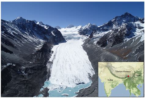
Climate change remains one of the project’s strongest motivations. Across Central Asia and the Tibetan Plateau, glaciers have been retreating at alarming rates over recent decades, threatening freshwater supplies, increasing the likelihood of glacial lake outburst floods, and destabilizing mountain environments. These changes have broad implications for agriculture, infrastructure, energy production, and millions of people who rely on glacier-fed river systems throughout the region.
AI-Powered Satellite Intelligence for Faster Disaster Warnings
A defining feature of the Tianwu Constellation is its integration of artificial intelligence. Rather than relying solely on human analysts, the enormous volume of satellite imagery and environmental measurements will be processed by sophisticated AI systems hosted at a dedicated data center in China’s Xinjiang region. These algorithms will continuously analyze geological activity, weather patterns, glacier movement, vegetation changes, and other environmental indicators to identify warning signs that may precede natural disasters.
As more observational data becomes available, the AI models are expected to become increasingly accurate through continuous learning. This evolving analytical capability could eventually identify subtle environmental patterns that traditional forecasting methods might overlook, allowing authorities to issue earlier warnings for earthquakes, landslides, glacial floods, and widespread agricultural threats such as pest outbreaks.
The initiative also builds upon China’s growing expertise in satellite-based environmental monitoring. The country’s BeiDou satellite navigation system already supports emergency response operations by providing positioning services and disaster monitoring capabilities. Tianwu represents the next phase of that strategy, expanding from navigation into comprehensive environmental intelligence powered by real-time remote sensing and machine learning.

Monitoring Asia’s Most Vulnerable Mountain Regions
Mountain ranges throughout western China and Central Asia remain among the world’s most environmentally sensitive regions. Rising global temperatures have accelerated glacier melting, altered seasonal water availability, and increased geological instability. These changes threaten transportation networks, hydropower facilities, farming communities, and downstream cities that depend on predictable river flows.
Continuous satellite observation provides scientists with a valuable perspective that ground-based monitoring alone cannot achieve. High-frequency imaging enables researchers to track glacier retreat, detect newly forming glacial lakes, monitor snowpack variations, and identify subtle land deformation that may indicate increased geological risk.
Balancing Scientific Cooperation With Security Concerns
Despite its scientific objectives, the Tianwu Constellation has also generated international discussion regarding potential security implications. Because Earth observation satellites can capture detailed imagery across vast geographic areas, experts note that similar technologies have historically served both civilian and strategic purposes.
China’s previous deployment of advanced observation satellites, including the Yaogan-41 platform, prompted concerns among some defense analysts regarding surveillance capabilities across the Indo-Pacific region. Although no evidence suggests the Tianwu project is intended for intelligence gathering, critics argue that limited public information regarding data collection policies, imagery access, and AI processing procedures leaves important questions unanswered.
Ultimately, the Tianwu Constellation represents both a technological milestone and a geopolitical balancing act. If implemented transparently and collaboratively, the satellite network could substantially improve disaster prediction across Asia while demonstrating how advanced space technology and artificial intelligence can help societies better prepare for an increasingly unpredictable climate.


