
India is entering a new era of space-based military surveillance with a cutting-edge initiative poised to reshape regional security architecture. Under the Space-Based Surveillance (SBS) programme, the nation is preparing to launch 52 AI-enabled satellites into Low Earth Orbit (LEO) and Geostationary Orbit (GEO), creating a dynamic, intelligent constellation that will surveil enemy military movements and monitor cross-border militant activity in real time.
Backed by an estimated ₹27,000 crore (approx. $3.2 billion) investment, this ambitious surveillance network will drastically reduce India’s reliance on foreign satellite imagery. The initiative is spearheaded by the National Security Council Secretariat and the Defence Space Agency (DSA) in cooperation with the Indian Space Research Organisation (ISRO) and select private-sector partners.

Strategic Vision: A High-Tech Surveillance Grid
The SBS programme is more than just a technological upgrade—it is a transformational leap in India’s strategic deterrence. These satellites will be armed with onboard artificial intelligence to autonomously analyze images, detect anomalies, and initiate real-time tasking across the constellation. This means a satellite in GEO can command one in LEO to zoom in on suspicious activities—whether that’s a troop movement near the Line of Actual Control (LAC) or the emergence of new infrastructure along contested borders.
As per ISRO Chairman S. Somanath, who outlined the vision during Techfest 2023 at IIT Bombay, over 50 satellites will be launched within five years for geo-intelligence collection. This interlinked AI-driven constellation will cover thousands of kilometers daily, ensuring comprehensive oversight across land and sea domains.
“Instead of downlinking every pixel of data for human inspection,” explained Somanath, “AI will flag threats, significantly reduce bandwidth consumption, and deliver only critical, actionable intelligence to military commanders.”
AI-Driven Surveillance: The Core of Smart Reconnaissance
At the heart of the new constellation lies a multi-sensor AI platform that processes imagery across different spectrums—optical, Synthetic Aperture Radar (SAR), and Thermal Imaging (TI). This combination enables 24/7, all-weather surveillance that doesn’t depend on visibility or daylight.
By merging satellite communication protocols and AI, these space assets will form a responsive grid that learns, adapts, and repositions based on threat analysis. The move toward autonomous space intelligence is in line with global trends seen in the U.S., China, and Israel, placing India on an equal conceptual footing in terms of space-based military AI.
Historical Evolution: From Phase 1 to a Fully Fledged Space Command
India’s journey into military-grade satellite surveillance began under Prime Minister Atal Bihari Vajpayee in 2001. In Phase 1, satellites such as Cartosat-2A, Cartosat-2B, and RISAT-2 were launched for earth observation and early military reconnaissance.
Phase 2, initiated in 2013, expanded the capability with Cartosat-2C, Cartosat-2D, Cartosat-3A/3B, and Microsat-TD. The integration of Synthetic Aperture Radar (SAR) through RISAT-2A enabled India to detect underground and camouflaged targets in any weather condition—an asset critical for monitoring both the western and eastern borders.
Additionally, dedicated communication satellites under the GSAT-7 series were deployed to enable secure, high-speed military networking. Notable among them:
- GSAT-7 Rukmini (Indian Navy)
- GSAT-7A Angry Bird (Indian Air Force)
- GSAT-7B, 7C, and 7R (Upcoming)
Each platform supports secure, real-time coordination between air, sea, and ground assets, reinforcing India’s capacity for network-centric warfare.
Phase 3: The Quantum Leap in India’s Space Surveillance
Approved in October 2024, Phase 3 is the most advanced and expansive yet. It includes:
- 52 satellites to be launched before end-2026, ahead of the original 2027–28 schedule
- 21 satellites to be co-developed with France under a bilateral defense cooperation agreement
- 31 satellites to be built by three classified private firms in South India
The mission aims to:
- Ensure real-time coverage of the Line of Actual Control (LAC) with China and border areas with Pakistan
- Track infrastructure build-up, especially roads, airstrips, and barracks along disputed zones
- Enhance Indo-Pacific maritime surveillance, especially detection of underwater platforms and Chinese reconnaissance vessels
- Aid civilian applications such as disaster management, weather analytics, and environmental changes including glacial retreat and forest loss

Private Sector Innovation: A New Era of Defence Manufacturing
The SBS Phase 3 opens up unprecedented opportunities for India’s private sector, encouraged by the 2023 National Space Policy that promotes public-private partnerships.
A prime example is Tata Advanced Systems Ltd (TASL). Their TSAT‑1A, launched aboard SpaceX’s Falcon 9 in April 2024, marked a critical milestone in India’s private satellite capabilities. Weighing 50 kg and based on the Satellogic NewSat Mark V bus, the satellite delivers sub-meter resolution imagery with rapid revisit times—an essential characteristic for tactical battlefield intelligence.
By harnessing agile private engineering alongside established institutional frameworks like ISRO and DRDO, India is building a resilient hybrid ecosystem for space security. This ecosystem can scale production and innovation simultaneously, accelerating capability while reducing foreign dependency.
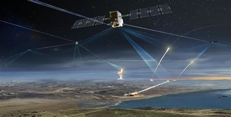
Inter-Satellite Communication: The ‘Talk’ in “Satellites Will Talk”
Perhaps the most groundbreaking capability lies in inter-satellite communication. Through laser links or high-frequency radio bands, the satellites will form an orbital mesh network capable of sharing and tasking data independently.
For example, a GEO satellite might detect suspicious vehicle movements along a Himalayan pass. It can instantly signal a LEO satellite to conduct high-resolution imaging of that zone within minutes. This “sensor-to-shooter” latency reduction turns strategic space assets into tactical battlefield enablers.
Such a network dramatically shortens the time between detection and response—a crucial advantage in modern hybrid warfare, where timelines are measured in minutes, not hours.
Geo-Intelligence Meets Electronic Warfare: The EMISAT Edge
Among the most intriguing satellites is EMISAT, developed under DRDO’s Project Kautilya. Unlike imaging satellites, EMISAT specializes in electronic intelligence (ELINT), locating enemy radar installations, communication hubs, and jammers.
Its contribution is pivotal in conflict situations where electronic warfare (EW) capabilities determine the survivability of fighter aircraft and missiles. EMISAT provides accurate real-time mapping of electromagnetic activity, thereby helping neutralize adversarial electronic threats.
Additionally, the Microsat-R, launched in 2019, serves dual roles—earth observation and potential kinetic testing, as seen during Mission Shakti, India’s first successful anti-satellite (ASAT) test.
A Strategic Shield in a Volatile Neighborhood
The SBS program arrives at a time of escalating regional tension. China’s Tiangong Space Station and its own robust military satellite fleet, including high-resolution Yaogan reconnaissance satellites, have already given it a significant edge in the region. Meanwhile, Pakistan has reportedly been deepening space ties with China.
India’s AI-powered satellite constellation is therefore more than a technology milestone—it is a strategic necessity. With aggressive border posturing by adversaries and a complex maritime environment in the Indo-Pacific, India must maintain an uninterrupted surveillance umbrella.
The full realization of SBS Phase 3 will mark the country’s entry into the elite league of nations with autonomous, intelligent space warfare infrastructure. This capability will enable not only deterrence but also ensure battlefield dominance in the future multidomain combat environment.
Conclusion: Satellites That Think, React, and Defend
India’s AI-integrated satellite grid represents the future of defence: adaptive, autonomous, and all-seeing. From tracking enemy movements to detecting submarines in the Indian Ocean, these orbiting sentinels will form a tight web of data, intelligence, and command.
This new network will transform satellites from passive observers into active combat enablers—a feat that redefines both India’s military doctrine and its role in global space geopolitics.
With over 100 military satellites projected within the next 7–8 years, and a dedicated Space Command in the making, India’s orbital rise is no longer theoretical. It is strategic reality in motion.


