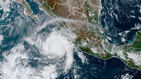
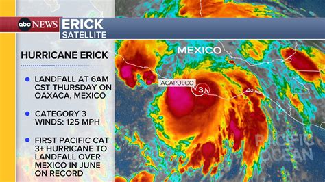
Hurricane Erick, the fifth named storm of the 2025 Eastern Pacific hurricane season, made landfall early Thursday morning as a Category 3 hurricane in southern Mexico’s Oaxaca state. The National Hurricane Center (NHC) confirmed that Erick struck with sustained winds of nearly 125 mph, down from an earlier Category 4 classification; however, the storm’s impact remains significant. Despite the downgrade, Erick’s powerful winds and torrential rains are expected to result in “life-threatening flooding and mudslides” across parts of Mexico, particularly in regions characterized by steep terrain.
The NHC warned that areas impacted by the storm should prepare for severe weather, including high winds, dangerous storm surges, and potential tornadoes. The residents of Oaxaca, Guerrero, and neighboring states are bracing for one of the most intense storms of the season, as they grapple with both the immediate threats posed by the hurricane and the long-term ramifications of such natural disasters.
Erick Strengthens to Category 4 Before Landfall
On Thursday morning, just before landfall, Erick had rapidly intensified to a Category 4 hurricane, boasting maximum sustained winds of 140 mph. However, as it approached the coastline, the storm began to weaken, ultimately making landfall in the western part of Oaxaca, just east of Punta Maldonado. The hurricane’s winds extended up to 25 miles from the center, while tropical storm-force winds reached as far as 90 miles. Despite the storm’s initial rapid intensification, the NHC confirmed that Erick is expected to weaken quickly once it moves inland. The mountainous terrain of Mexico will likely cause the system to dissipate by Thursday night or early Friday.
Life-Threatening Flooding and Mudslides Expected
Erick’s most significant threat comes from heavy rainfall, with the NHC forecasting that the storm will bring between 8 to 12 inches of rain, with isolated amounts potentially reaching up to 16 inches. The states of Oaxaca and Guerrero are anticipated to see the highest rainfall totals, which could lead to devastating flooding and mudslides, particularly in areas with steep slopes. Other states, including Chiapas, Michoacán, Colima, and Jalisco, are expected to receive between 2 to 4 inches of rain. This excess rainfall, coupled with the mountainous terrain, will likely create hazardous conditions, prompting authorities to urge residents to be prepared for the worst.
Storm Surge and Coastal Impact
Alongside heavy rainfall, Erick is expected to produce dangerous storm surges, which will cause coastal flooding near and west of the hurricane’s center. The NHC described the storm surge as “life-threatening” and noted that it would be accompanied by “large and destructive waves.” Areas along the coast, especially near Acapulco and surrounding regions, are likely to experience significant damage from rising sea levels and rough surf conditions. Acapulco, which was devastated by Hurricane Otis in October 2023, is among the areas facing the brunt of Erick’s impact. Otis, a Category 5 storm, struck the city with wind speeds increasing by 115 mph in just one day, marking the second-fastest recorded rate of intensification in modern hurricane history. The damage caused by Otis left dozens dead, and the memory of this catastrophic storm has heightened concerns about Erick’s potential for destruction.
Hurricane Warnings and Watches in Effect
As of Thursday morning, a hurricane warning is in effect from Acapulco to Puerto Angel, while a hurricane watch has been issued for areas west of Acapulco to Tecpan de Galeana. These warnings indicate that hurricane conditions are expected in the coming hours, and residents in these regions should take immediate precautions to protect themselves and their property. The NHC has emphasized that even though Erick is weakening, the storm still poses significant risks due to its strong winds, rain, and storm surge. It is crucial for residents and travelers in the affected areas to stay informed and follow local authorities’ guidance.
The Impact of Hurricane Erick on Mexico’s Infrastructure
Category 3 hurricanes like Erick can cause “devastating damage,” according to the National Oceanic and Atmospheric Administration (NOAA). The storm’s winds can lead to power outages lasting from several days to weeks, disrupting daily life and potentially causing long-term economic impacts. Additionally, strong winds can result in fallen trees, damaged buildings, and transportation disruptions. The NHC has also warned of potential tornadoes that may develop in the storm’s outer bands, further complicating recovery efforts for affected regions.
Forecast for the Rest of the Hurricane Season
Erick is the first major hurricane of the 2025 Eastern Pacific hurricane season, which runs from May 15 to November 30. The storm highlights the dangers posed by early-season hurricanes, and meteorologists are closely monitoring other areas of concern as the season progresses. The Atlantic hurricane season, which runs from June 1 to November 30, will also present challenges for coastal communities. As of now, the NHC is focused on Erick’s immediate impacts, but further monitoring of the Pacific and Atlantic basins will continue throughout the season. With the potential for additional storms forming, local authorities are advising residents to remain vigilant and prepared for future events.
Conclusion: Preparing for the Aftermath
While Hurricane Erick is expected to weaken as it moves inland, the storm’s impacts are far from over. Life-threatening flooding, mudslides, and storm surges are imminent in several regions of southern Mexico, particularly in Oaxaca, Guerrero, and surrounding areas. The ongoing threat of severe weather calls for continued vigilance from local authorities, emergency services, and residents. The NHC, along with local governments, are urging those in the path of the storm to remain indoors, avoid traveling, and stay updated on the latest warnings. As Erick continues to move inland, it is expected to dissipate, but its legacy of destruction will likely affect the region for some time.


