Minimum Vectoring Altitude (MVA)
Minimum Vectoring Altitude (MVA) is the lowest altitude, measured in feet Above Mean Sea Level (AMSL), to which a radar controller can clear aircraft during vectoring or direct routing. This is unless other permissions are granted for radar approaches, departures, or missed approaches. MVA can also be known as Minimum Flight Altitude (MFA), Minimum Radar Vectoring Altitude (MRVA), or ATC Surveillance Minimum Altitude (ASMA). For this article, we will stick with the term MVA.
What is Vectoring?
Vectoring refers to the navigational guidance provided to aircraft through specific headings, utilizing an air traffic services surveillance system (ICAO Doc 4444, PANS-ATM).
Designing MVAs
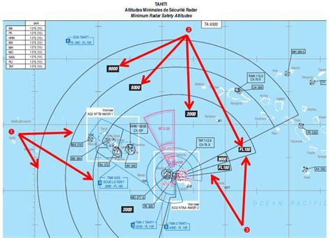
MVAs are set for Air Traffic Controllers (ATCOs) when they provide a surveillance service, typically radar. Each MVA chart displays sectors that are large enough to allow aircraft vectoring at the MVA. The sector boundaries are located at least 3 miles from any obstruction that determines the MVA for that area. To avoid excessively high MVAs due to isolated obstacles, these obstacles may be enclosed in a buffer zone of at least 3 miles. The minimum vectoring altitude must ensure 1,000 feet above the highest obstacle in non-mountainous areas and 2,000 feet in designated mountainous regions. Essentially, the MVA is the lowest altitude that meets the necessary obstacle clearance requirements in that airspace.
MVA Chart Publication
MVA charts need approval from relevant authorities, often the Civil Aviation Administration (CAA), and are published in the Aeronautical Information Publication (AIP) as part of the Aerodrome section related to specific aerodromes. According to ICAO Annex 4, Chapter 21, these charts should help flight crews monitor and verify altitudes assigned by controllers using an ATS surveillance system. MVA charts are especially useful where vectoring procedures are established, but excessive chart clutter prevents clear display on Area Charts, Standard Departure Charts (SID), or Standard Arrival Charts (STAR). As per ICAO Annex 15, Chapter 4, these charts should be available for designated international aerodromes/heliports and included in the AIP or distributed separately.
Visualizing MVAs
To assist ATCOs with minimum vectoring altitudes, MVA chart data can be integrated into the radar data display system. This data appears on radar maps, aiding the ATCO in maintaining safe operations.
Responsibilities of Pilots
The pilot-in-command is responsible for the safe operation of the aircraft and ensuring clearance from obstacles, except when being vectored by radar. If ATC is not providing radar service and the pilot accepts a direct route off the published path, the pilot is fully responsible for obstacle clearance. In these cases, the Minimum Sector Altitude (MSA) must be respected. The pilot must closely monitor their position using navigation aids to minimize reliance on radar assistance and manage potential radar failures. Continuous communication with the ATCO is crucial, and if further instructions are not received within a suitable timeframe, or in case of a communication failure, the pilot should climb to the minimum sector altitude. The determination of usable flight levels by ATC does not relieve pilots of their responsibility for terrain clearance unless they are being vectored by radar. Some operators impose limits on descent clearance based on MSA, and pilots have occasionally declined ATC descent clearances to MVAs lower than MSAs, which can impact traffic flow and safety. If there is any concern about a cleared altitude posing a collision risk, the flight crew should seek clarification from ATC.
Responsibilities of ATCOs
Air traffic control objectives, as outlined in ICAO Annex 11, do not include preventing collisions with terrain. Procedures in Doc 4444, PANS-ATM, do not absolve pilots of their responsibility for ensuring safe clearances. While vectoring an IFR flight, controllers must issue clearances that maintain the prescribed obstacle clearance until the aircraft reaches the point where the pilot will resume navigation. According to Doc 8168 PAN-OPS, ATC may assign MVAs below the minimum sector altitude when an IFR flight is being vectored by radar, ensuring obstacle clearance at all times until navigation is resumed. Using phrases like “turn left (or right) heading…” or “resume own navigation” helps pilots understand the nature of the ATC service and their clearance responsibilities better.
")
")
")
")
")
")


