Alert Areas are among the six Special Use Airspaces (SUA) defined by the Federal Aviation Administration (FAA) to highlight zones where flight operations deviate from the norm. While not regulatory like Prohibited or Restricted Areas, Alert Areas present a very real hazard to unsuspecting pilots. These areas are designated primarily to inform nonparticipating pilots about high concentrations of unusual aerial activity, most commonly student pilot training. This may include aggressive maneuvers, high-speed passes, steep turns, or other behavior uncommon in standard air traffic environments.
Understanding the Purpose of Alert Areas
The Aeronautical Information Manual (AIM) defines Alert Areas as “areas depicted on aeronautical charts to inform nonparticipating pilots of areas that may contain a high volume of pilot training or an unusual type of aerial activity.” The distinction here is important: these are informational rather than regulatory zones. They do not require prior permission to enter, and no controlling agency governs them. But they can host intense and erratic aircraft activity that demands heightened situational awareness.
Unlike Military Operations Areas (MOAs) which aim to separate IFR traffic from military activities, Alert Areas serve as a visual caution to general aviation pilots, essentially saying: “Enter at your own risk.” You won’t see consistent altitude layers or calm flight paths here. Student pilots training in these regions are often pushing aircraft to performance limits. Expect unconventional speeds, altitudes, and flight paths, and anticipate multiple aircraft in tight proximity.
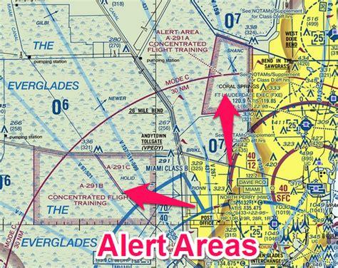
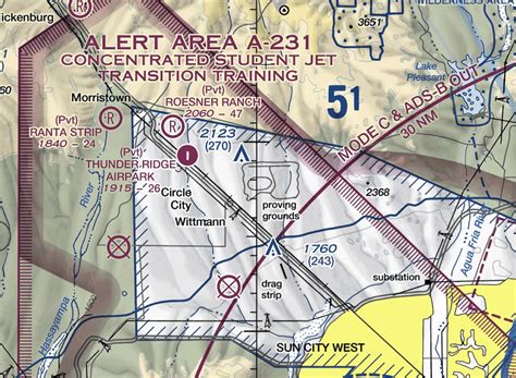
Recognizing Alert Areas on VFR Charts
Alert Areas are identified on VFR Sectional Charts by magenta-hashed boundaries and carry designations like “A-291” or “A-381.” Unfortunately, Alert Areas can closely resemble MOAs on a chart, and often, MOAs are embedded within them. This visual similarity can confuse even experienced pilots. However, VFR Sectionals will typically include an accompanying legend that lists the lateral and vertical boundaries of each Alert Area and offers notes about its common usage times and activities.

To confirm active times, examine both the chart itself and the sectional margin data. In some cases, the specific operational times or limitations may be printed adjacent to the designated area. If not, refer to the sectional index panel on the chart’s edge, which provides a detailed table of all nearby SUAs.
How to Determine When an Alert Area is Active
Unlike MOAs or Restricted Areas, Alert Areas do not have published NOTAMs for activation. They may be active daily, multiple times per day, or sporadically. This lack of regulatory structure makes planning more difficult but not impossible. The best pilots employ a combination of resources to identify high-risk periods:
- Consult a local CFI (Certified Flight Instructor) at an airport within the Alert Area. These individuals often have firsthand insights into scheduling patterns.
- Talk to local student pilots. They know when sorties occur, and training cycles often repeat weekly.
- Call the nearby base or training school, but be transparent about your inquiry. Vague or suspicious calls might trigger security concerns.
- Watch for patterns if you live nearby. You’ll likely begin to recognize daily activity rhythms and quiet periods.
- Check digital VFR charts on SkyVector.com. But beware: only the named sectional charts (e.g., Miami, Albuquerque) show Alert Area info — not the “World VFR” base layer.
A common example of time segmentation includes three daily periods: 0730–1130, 1330–1730, and 1930–2330, with briefing gaps in between. Even if a chart lists active hours from 0600 to 2200, understanding these internal windows can help you transit during safer moments.
Flying Safely Through Alert Areas
Avoidance remains the best strategy, but in many cases, that’s neither practical nor fuel-efficient. If you must pass through an Alert Area, implement these best practices:
- Fly above or below the designated ceiling/floor. For instance, if an Alert Area extends from surface to 2000 feet MSL, flying at 3500 feet VFR is both legal and safe.
- Schedule flights on weekends or federal holidays. Military and student training flights almost never occur during these times, especially around Christmas or Presidents’ Day.
- Avoid peak hours. Morning and afternoon periods are most active. Planning flights during briefing windows helps avoid cluster zones.
- Maintain extra vigilance. These areas may have no radio contact, no radar separation, and no ATC oversight. It’s all see-and-avoid.
Legal Considerations and Misconceptions
It’s important to emphasize that Alert Areas are not controlled airspace, and no permission is needed to enter them. This can lull pilots into a false sense of security. Legally, you may fly through at any time, but doing so without proper awareness can lead to near misses, especially in areas dense with T-6 Texan IIs, helicopter autorotation drills, or aerobatic student patterns.
These airspaces are often located near military flight training installations, university aviation programs, or large flight schools, particularly in states like Florida, Texas, and Arizona. You’ll find Alert Areas near bases like Naval Air Station Whiting Field or Sheppard Air Force Base, where training volume is intense.
Research Tools and Resources
Several digital tools help streamline Alert Area research:
- SkyVector.com: Use sectional charts with full legends to find lateral and vertical boundaries.
- ForeFlight: Check airspace overlays with time-sensitive notes.
- FAA VFR Sectionals (PDF): Download the exact charts used in SkyVector for offline reference.
- Local FBO briefings: Fixed-Base Operators often keep logs or have anecdotal data about local training routines.
Final Thoughts: Fly Smart, Not Blind
While Alert Areas aren’t dangerous in the legal sense, they represent risk zones due to the unpredictable and dynamic nature of student training operations. A well-briefed pilot armed with updated chart data, local insight, and temporal awareness can safely navigate them. But the key lies in preparation.
By understanding the structure, purpose, and operational rhythms of Alert Areas, pilots can make informed decisions that protect both their aircraft and their logbooks. When in doubt, fly around, fly above, or fly during the breaks.
Always remember: Alert Areas are not obstacles — they’re warnings.


: Navigating Danger Zones in U.S. Airspace")
: Navigating Special Use Airspace Safely and Legally")


 in Aviation")