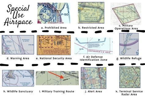
Restricted areas, as one of the six categories of Special Use Airspace (SUA), form a critical component of aviation regulation and pilot safety in the United States. Unlike prohibited areas, where flight is categorically forbidden, restricted areas are defined by the Federal Aviation Administration (FAA) as “airspace identified by an area on the surface of the earth within which the flight of aircraft, while not wholly prohibited, is subject to restrictions.” These zones are designated primarily to protect aircraft from hazardous activities conducted on the ground or in the air.
Restricted airspace can harbor anything from artillery firing, aerial gunnery, missile testing, to military exercises, any of which can pose lethal risks to non-participating aircraft. The presence of a restricted area implies a dynamic airspace condition that could shift without notice. Consequently, pilots—particularly those flying under Visual Flight Rules (VFR)—must take proactive measures to avoid unintended airspace violations.
Regulatory Nature and Strategic Purpose
Restricted areas are regulatory in nature, meaning they are codified in law and must be respected by all aviators regardless of intent or circumstance. These zones often overlay military installations or specialized testing grounds such as Area 51 in Nevada or the Quantico Marine Corps Base in Virginia. Each restricted area is governed by a controlling agency, usually a regional Air Route Traffic Control Center (ARTCC), such as Seattle Center or Los Angeles Center, depending on the region.
Importantly, restricted areas are not permanently active. They oscillate between “hot” (active) and “cold” (inactive) statuses depending on scheduled operations. Permission from the controlling agency is mandatory before entry, unless the airspace is confirmed to be inactive. Even then, verbal coordination with ATC is highly recommended, as altitude and operational timelines can be misinterpreted.
Flight Planning Considerations: VFR vs IFR
One of the most critical decision points for pilots planning to navigate around or through restricted airspace involves understanding their flight plan type.
- Under Instrument Flight Rules (IFR), pilots often file routes that pass directly through restricted areas. This is standard practice because ARTCCs will automatically reroute aircraft if the airspace is active.
- Under Visual Flight Rules (VFR), the responsibility lies entirely with the pilot to determine airspace status and plan accordingly. ATC is not obligated to provide course corrections unless the pilot is on Flight Following.
For instance, a typical IFR flight from Portland, Oregon to Spokane, Washington may include routing through the Yakima restricted zone. If the range is active, Seattle Center will automatically adjust the route. By contrast, a VFR pilot flying the same route must manually verify the airspace status and adjust course or altitude as needed.
Altitude Restrictions and Workarounds
Not all restricted areas extend through all altitudes. Many are confined to lower flight levels, allowing overflight or underflight based on aircraft capability and mission.
Take for example the restricted area near Pendleton, Oregon—it tops out at 6,000 feet MSL. A VFR pilot cruising at 7,000 feet can safely fly over without a clearance, provided terrain clearance is acceptable. However, this assumes a clear understanding of sectional charts and Special Use Airspace (SUA) tables.
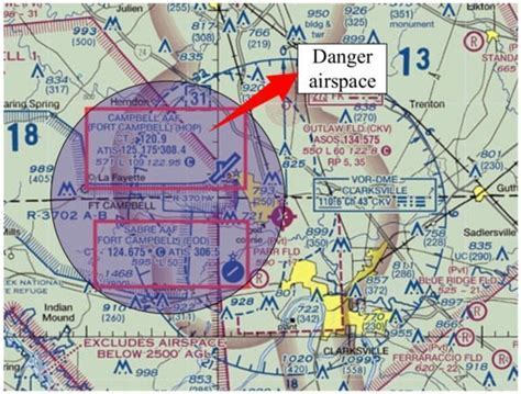
For cluttered charts or low-resolution maps, pilots should cross-reference with the VFR sectional legend, which lists detailed descriptions of the SUA zones, including vertical limits and activity schedules.
Temporal Activity and How to Check It
A restricted area’s status is not static. Pilots must determine when a restricted area is active. This is where NOTAMs (Notices to Air Missions), FSS (Flight Service Station) briefings, and chart annotations become essential tools.
Sectional charts often denote operating times in formats like SR-SS (Sunrise to Sunset), or will refer users to NOTAMs for current status. However, NOTAMs should not be the sole authority. They can be incomplete, outdated, or simply difficult to locate amid a sea of unrelated advisories.
Pilots are advised to:
- Use apps like ForeFlight or Garmin Pilot to locate ARTCC NOTAMs.
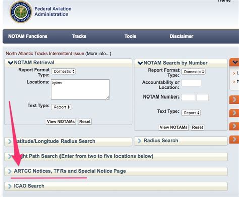
- Visit the official FAA NOTAM Search site and filter by ARTCC code.
- Confirm active times by calling FSS directly and then double-checking with ATC when airborne.
A critical reminder: the absence of a NOTAM does not imply inactivity. Many restricted zones operate on fixed schedules that do not generate daily notices. Blindly assuming a “cold” status could result in a license violation or worse.
Identifying the Controlling Agency
Every restricted area is managed by a designated ATC entity. To identify the appropriate controlling agency:
- Refer to the Special Use Airspace chart on your VFR sectional.
- Look for the listed frequency and name of the ARTCC or military coordination desk.
- Maintain open communication with that agency throughout your flight segment.
Even if the restricted area is inactive, it is best practice to notify ATC of your intention to overfly or navigate near it. This not only adds a layer of legal compliance but enhances situational awareness and safety.
For new pilots, speaking with ARTCC can feel daunting. This is where resources like “Radio Mastery for VFR Pilots” by Jeff Kanarish become invaluable. These books break down the complexities of radio communication in structured, practical terms that can bolster both skill and confidence.
Real-World Examples of Restricted Zones
Some restricted airspace designations have become legendary due to their cultural or strategic significance. Area 51, officially known as Groom Lake Test Facility, is both a Prohibited and Restricted Area. Unauthorized overflight is not only illegal—it’s intercepted.
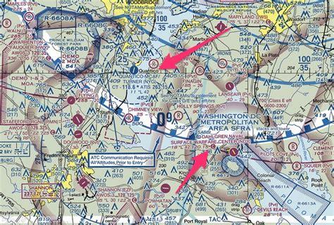
Similarly, areas surrounding Washington D.C., Fort Lewis (WA), and Naval Surface Warfare Center (VA) feature layers of restricted zones used for low-level helicopter training, live-fire exercises, and special forces operations. The scope and complexity of these areas mean they often exceed dozens of nautical miles in lateral spread and tens of thousands of feet in vertical range.
Pilots operating in western states like Nevada or Utah often encounter massive restricted complexes used by the U.S. Air Force. These cannot always be circumvented due to their scale, and thus require special coordination for transition.
Navigational Strategies and Best Practices
In summary, we advise all pilots, regardless of certification level, to treat restricted airspace with the utmost caution. The general rule of thumb: go around unless there is a compelling reason not to. If deviation is required, follow this structured decision tree:
- Flight Plan Type: Are you VFR or IFR?
- Vertical Profile: Can you fly over or under the restricted zone?
- Activation Time: Is the area currently in use?
- Controlling Agency: Who do you call for clearance?
These four points form the backbone of safe restricted area navigation. An omission in any of them could jeopardize your safety, certification, or both.
Final Thoughts
Navigating restricted airspace is not inherently difficult—but it demands discipline, preparedness, and respect for regulations. With the right tools, current charts, verified NOTAMs, and clear communication with ATC, it is entirely possible to fly safely and legally around or even through these zones when conditions permit.
The FAA offers dynamic, graphical depictions of all SUA regions via its Special Use Airspace Live Site, which we strongly encourage all pilots to bookmark and consult during pre-flight planning. While it may take extra time to plan around these airspaces, the price of non-compliance—both in terms of safety and legal standing—is far steeper.

: Navigating Special Use Airspace Safely and Legally")

 in Aviation")


