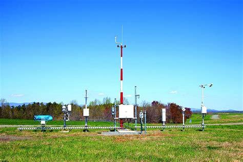
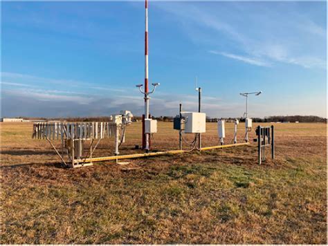
Automated Surface Observing System (ASOS) stands at the forefront of modern meteorological infrastructure in the United States. A joint venture by the National Weather Service (NWS), the Federal Aviation Administration (FAA), and the Department of Defense (DOD), ASOS serves as the primary surface weather observation network, enabling precise atmospheric monitoring at over 1,000 locations nationwide. From safeguarding aviation operations to fueling climatological research, ASOS is not just a tool — it is a national necessity.
Strategic Relevance in National Aviation Safety
We recognize that in the realm of aviation safety, real-time surface weather data is indispensable. ASOS is deployed strategically across civilian and military airfields, providing minute-by-minute updates around the clock. These high-frequency observations are crucial to flight planning, takeoffs, landings, and en-route operations. Without them, delays, diversions, and even cancellations could ripple across domestic and international air networks, affecting passengers, cargo, and the economy.
Each ASOS station is typically situated at the runway touchdown zone — the most critical point for visibility, wind, and precipitation data. This precise placement ensures that pilots, air traffic controllers, and dispatchers receive reliable and hyperlocal atmospheric information, dramatically reducing uncertainty during dynamic weather conditions.
Continuous 24/7 Atmospheric Monitoring
Operating 365 days a year, ASOS reports the current weather conditions with remarkable consistency. The system’s data output occurs every minute, and special updates are triggered automatically when meteorological thresholds are surpassed. These parameters are predefined under FAA JO 7900.5E, ensuring uniform reporting across all units.
ASOS isn’t limited to routine updates. It can detect and report sudden weather phenomena such as:
- Rapid pressure changes
- Wind shifts
- Peak gusts or squalls
- Onset or cessation of precipitation
- Variable visibility and cloud height patterns
These dynamic elements are incorporated into METAR and SPECI reports — the standardized formats for aviation weather reporting. ASOS is fully automated, yet its outputs are robust enough for real-time decision-making across multiple sectors.
Core Weather Parameters Observed by ASOS
What makes ASOS scientifically valuable is the breadth and precision of its atmospheric data collection. The following key meteorological elements are continuously monitored and recorded:
- Sky Condition: Layered observations of cloud cover (clear, scattered, broken, overcast) up to 12,000 feet AGL.
- Visibility: Ranges from zero to 10 miles, including obstructions such as fog, haze, or smoke.
- Present Weather: Real-time type and intensity for rain, snow, and freezing rain.
- Atmospheric Pressure: Sea-level pressure and altimeter settings for aircraft calibration.
- Temperature & Dew Point: Ambient and dew point temperature, essential for icing predictions and humidity analysis.
- Wind Characteristics: Direction, sustained speed, and gusts — critical for crosswind landings and turbulence assessments.
- Precipitation Accumulation: Both liquid and frozen water equivalents, updated continuously.
Technological Integration and Communications
Each ASOS station is a self-contained, automated unit composed of specialized sensors, data processors, and communication modules. These components interact in real-time to observe, archive, and disseminate meteorological data. The stations are capable of:
- Issuing real-time voice broadcasts over FAA ground-to-air radio frequencies
- Delivering phone-based voice weather updates for aircraft outside radio range
- Streaming data to centralized repositories for integration with weather models and forecasting systems
This level of automation ensures zero latency in data availability. Moreover, the system’s architecture minimizes the need for human intervention, thereby reducing reporting bias and operational cost.
Backbone of Meteorological and Climatological Research
Beyond aviation, ASOS plays a pivotal role in meteorological science, hydrology, and climate monitoring. The archived data is foundational for:
- Trend analysis of temperature, humidity, and wind patterns
- Severe weather event studies, including snowfall intensity and drought onset
- Long-term climatological assessments for environmental planning and regulation
National and international agencies frequently access ASOS databases to support research projects, policy design, and climate change adaptation initiatives.
Operational Redundancy and National Coverage
The ASOS network’s redundant structure guarantees robust data flow even during natural disasters or technical failures. Sites are backed up by regional control centers and are continuously monitored for performance anomalies. This ensures maximum data integrity, even in high-impact weather scenarios like hurricanes, blizzards, or wildfires.
Geographically, ASOS units span the entire continental U.S., Alaska, Hawaii, and U.S. territories, creating a seamless observation grid. This extensive placement makes ASOS the most comprehensive surface-level weather monitoring system in the Western Hemisphere.
Economic Impact and Infrastructure Synergy
The indirect economic benefits of ASOS are immense. By preventing weather-related flight disruptions, ASOS contributes to:
- Operational efficiency in the commercial aviation sector
- Lowered insurance claims due to weather-induced accidents
- Fewer shipping delays across logistics networks
Furthermore, ASOS data feeds into the National Airspace System (NAS), synchronizing with air traffic control, airport management systems, and emergency response units. This synergy enhances national transportation resilience and disaster preparedness.
Future Enhancements and Modernization
Recognizing the evolving climate and aviation demands, federal agencies are continuously upgrading the ASOS infrastructure. Planned innovations include:
- Improved sensor resolution for more granular precipitation detection
- Enhanced visibility detection in complex terrain and coastal regions
- Machine-learning algorithms for anomaly detection and predictive maintenance
These enhancements aim to sustain ASOS’s operational excellence and reinforce its role in a climate-aware, safety-critical infrastructure ecosystem.
FAQs
What does ASOS stand for and what is its primary function?
ASOS stands for Automated Surface Observing System. Its primary role is to provide continuous, real-time surface weather observations critical for aviation safety, weather forecasting, and climatological research.
How often does ASOS update its weather data?
ASOS updates its observations every 60 seconds. It also issues special reports instantly when significant weather events occur, such as wind shifts, heavy precipitation, or rapid pressure changes.
Who operates and maintains ASOS stations across the country?
ASOS is a collaborative program managed by the National Weather Service (NWS), Federal Aviation Administration (FAA), and Department of Defense (DOD). Each partner maintains specific sites and ensures proper calibration, data quality, and performance reliability.

")


 System")


