In an unprecedented technological and cinematic achievement, DJI’s Mavic 4 Pro has captured a breathtaking, continuous aerial ascent of Mount Everest, offering the world a never-before-seen perspective of Earth’s highest peak. This feat not only pushes the boundaries of drone performance but also marks a turning point in high-altitude exploration and visual storytelling.
The Historic Flight: Everest Like Never Before
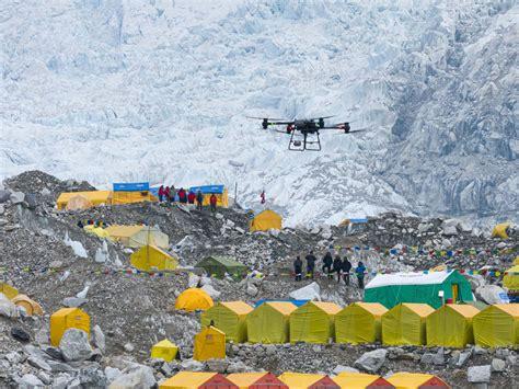
The project, spearheaded by renowned photographer Ma Chunlin, involved meticulous planning and technical mastery. The DJI drone ascended from 6,500 meters (21,325 feet) and soared to nearly 8,800 meters (28,870 feet), brushing the summit’s edge — all captured in a seamless, uninterrupted flight sequence.
Operating a drone at these altitudes presents formidable challenges. The air is dangerously thin, temperatures plummet to extreme lows, and unpredictable winds whip across Everest’s jagged slopes. Despite these conditions, the Mavic 4 Pro showcased exceptional stability, precise obstacle avoidance, and crisp 4K imagery, all while battling the mountain’s notorious weather.
The footage, which tracks the entire North Col route, is a triumph of both engineering and endurance. Viewers can witness the journey from base camp through the major acclimatization stops, all the way to the summit, with team members visible at key points along the way — a cinematic experience that places the audience directly amidst the expedition.
Breaking Down the Drone’s High-Altitude Capabilities
While the Mavic 4 Pro remains unavailable in the US market, its technical specifications have made waves internationally, especially among drone enthusiasts and professionals.
Key features that enabled this Everest ascent include:
- Advanced obstacle avoidance sensors designed to detect terrain irregularities and avoid collisions even in low-visibility conditions.
- High-performance motors capable of operating in the thin, oxygen-starved atmosphere of the Himalayas.
- Reinforced battery systems, optimized to function despite sub-zero temperatures that normally degrade lithium battery efficiency.
- A 4K camera system with an ultra-stable gimbal, delivering cinematic-grade footage with minimal distortion, despite extreme altitude vibrations.
The high-altitude success also hinges on pre-flight preparation, including strategies to keep battery cells warm and maximize flight duration — essential for completing the nearly 3,500-meter vertical climb, plus horizontal distance, within one battery cycle.
From Marketing to Mountain: The Broader Implications
Some critics argue that DJI’s Everest project represents a marketing spectacle, juxtaposed against the restrictive reality for everyday drone users. Across much of the world, especially in the US and Europe, recreational pilots face stringent regulations concerning altitude limits, flight paths, and visual line-of-sight (VLOS) requirements.
The Everest flight, however, exemplifies the potential for professional drone operations, conducted with necessary permits, to contribute meaningfully to exploration, research, and environmental efforts. As Ma Chunlin’s project demonstrates, when paired with careful planning and expertise, drones can unlock perspectives previously reserved for mountaineers and elite cinematographers.
Drones Reshaping Everest Expeditions
The impact of drone technology on Everest extends beyond cinematic beauty. DJI’s FlyCart 30, for example, has already been deployed to transport equipment and evacuate waste, addressing one of Everest’s most pressing issues — the accumulation of trash on the slopes.
Aerial logistics via drones can significantly reduce the physical burden on climbers, potentially improving safety margins and increasing the efficiency of high-altitude expeditions. Speculation within the climbing community suggests that future operations may involve drones carrying oxygen supplies or emergency gear directly to stranded climbers, possibly saving lives.
Overcoming Challenges: Thin Air, Extreme Cold, and Radio Range
Operating a drone at Everest’s altitude is far from simple. At heights above 8,000 meters, known as the “Death Zone,” oxygen levels are critically low, not just for humans but also for drone propulsion systems. The low air density forces motors to work harder to generate lift, drastically reducing battery life.
Furthermore, temperatures frequently plunge to -30°C (-22°F) or lower. Lithium batteries struggle to function efficiently in such conditions, often draining faster and risking failure. However, reports indicate that the Mavic 4 Pro, with pre-warmed batteries and precise engineering, managed to complete the mission within its expected flight window, despite these adverse conditions.
Communication range posed another hurdle. Maintaining a strong radio link between the drone and the ground operator is vital, especially in rugged terrain with frequent line-of-sight obstructions. Fortunately, the sparsely populated high-altitude environment of Everest minimized radio interference, allowing the drone to remain connected throughout the climb.
Public Reaction: Awe, Skepticism, and the Future of Drone Exploration
The video, shared on social platforms like Reddit’s r/drones, has sparked admiration and debate among enthusiasts and experts alike. Comments range from awe at the cinematography to curiosity about technical specifics, including questions on flight legality, battery performance, and obstacle avoidance in such extreme conditions.
Some skeptics question whether the ascent occurred in a single flight, citing the extreme vertical and horizontal distances involved. Yet, calculations indicate that with an estimated 25-minute cold-weather flight time, the drone had ample capability to complete the journey at realistic speeds — especially considering the Mavic 4 Pro’s top speed exceeds 90 kph (56 mph) under normal conditions.
Others humorously remarked on the juxtaposition of months-long human climbs versus a drone’s ability to summit in mere minutes, highlighting the rapid technological advancements reshaping exploration.
Regulatory Landscape and the Professional Divide
Despite the video’s viral success, some viewers raised concerns regarding VLOS (Visual Line of Sight) and altitude regulations. In the US, FAA 14 CFR Part 107 imposes strict limitations, including a maximum 400-foot (120-meter) AGL altitude for drones without special waivers. Similar limits exist in Nepal and China, though exceptions are often granted to professionals conducting sanctioned projects.
The Everest ascent underscores the growing divide between professional operations — supported by permits, advanced equipment, and rigorous planning — and the restrictive environment for hobbyists. For many drone pilots, flights at even modest altitudes are heavily regulated, contrasting with the bold capabilities showcased in the Everest footage.
Drones and the Evolution of High-Altitude Filmmaking
This milestone adds to a lineage of pioneering aerial filmmaking. While helicopters have reached Everest’s summit, as with Didier Delsalle’s historic landing, drones offer a more accessible, lower-risk method for capturing the Himalayas’ grandeur without endangering pilots.
Moreover, drones unlock new creative possibilities, providing close-range, stabilized footage impossible for crewed aircraft in the mountain’s narrow ridges and steep faces. The ability to track climbers, reveal base camps, and document the ascent from a dynamic aerial perspective enriches both the artistic and documentary value of Everest expeditions.
Looking Ahead: The Future of Drones on Everest
The Everest project demonstrates that drones are poised to play a vital role in the future of high-altitude exploration. Beyond filmmaking, they offer solutions for emergency response, environmental conservation, and even logistical support, reducing climbers’ load and enhancing safety.
As drone technology advances, with longer flight times, improved battery resilience, and enhanced obstacle navigation, it’s conceivable that drones will become indispensable tools in the Himalayas and other extreme environments.
For now, the world marvels at the striking imagery — a bold reminder that even the tallest mountain on Earth can be conquered by innovation, one propeller rotation at a time.


