A Historic Accidental Discovery Redefines Tsunami Science
In an unprecedented convergence of technology and timing, NASA’s Surface Water and Ocean Topography (SWOT) satellite, developed in collaboration with the French space agency CNES, has captured images of a tsunami that may dramatically shift our understanding of how these deadly ocean waves behave. While tsunamis are rare and dangerous, and their very nature makes them hard to study, this scientific breakthrough emerged serendipitously when a massive undersea earthquake struck just as SWOT was in orbit above the Pacific.
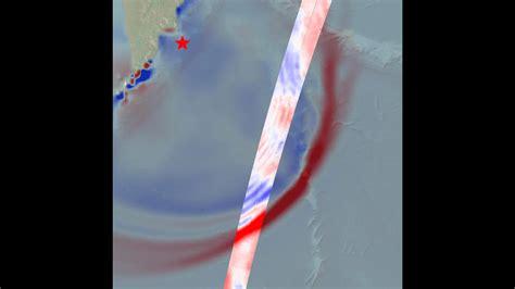
On July 29, 2025, a powerful magnitude 8.8 earthquake erupted beneath the ocean floor off the Kamchatka Peninsula in southeastern Russia. Within minutes, a tsunami began forming, spreading across the Pacific Ocean with waves surging from the seabed up to 1.5 feet above the surface. Just 70 minutes later, the SWOT satellite flew overhead, its suite of sensors—including radar interferometers, GPS, and microwave radiometers—capturing the tsunami in extraordinary detail.
Disproving Long-Held Models of Tsunami Movement
What the satellite observed contradicted decades of accepted models. Traditionally, tsunamis were believed to be non-dispersive, meaning the entire body of water moved as one cohesive force, like a giant pulse racing through the sea. But the high-resolution data from SWOT told a different story—one that defies the oversimplified assumptions of past models.
Instead of a single, unified wavefront, SWOT revealed a dispersive wave pattern, where the initial tsunami was followed by a series of smaller trailing waves, often referred to as a “wavetrain.” This nuanced behavior hints at more complex wave dynamics and challenges conventional hydrodynamic theories.
The implications of this observation are profound. If tsunamis are indeed dispersive in nature, new models will need to account for this multi-wave behavior, reshaping how scientists simulate, predict, and respond to future events. These models could dramatically enhance the early warning systems used by coastal communities across the globe.
SWOT’s Technological Leap and Real-World Validation
The SWOT satellite’s capabilities allow it to act like a “giant paintbrush” sweeping across the oceans, creating vivid topographic maps of water surfaces. Its readings, which show precise elevation changes, have opened an entirely new window into the physics of wave propagation.
As explained by Nadya Vinogradova Shiffer, SWOT Earth lead at NASA, “The power of SWOT’s broad, paintbrush-like strokes over the ocean is in providing crucial real-world validation, unlocking new physics, and marking a leap towards more accurate early warnings and safer futures.”
This real-time observation of a tsunami in motion from space underscores the critical value of space-based Earth science missions, particularly in an era of increasing climate volatility and extreme weather events. By validating theoretical physics through real-world imagery, SWOT positions itself not just as a technological marvel but as an invaluable tool in humanity’s arsenal against natural disasters.
Broader Impacts: Scientific Progress Amid Political Headwinds
While the tsunami imaging from SWOT represents a landmark achievement, it comes amid growing uncertainty about NASA’s future. Recent investigations and internal reports have painted a troubling picture. In November 2025, an NPR exposé revealed what it described as a “campaign of disruption” at NASA’s Goddard Space Center, citing an “information blackout,” staff reassignments, and abrupt project shutdowns.
At the heart of the disruption is a proposed 47% budget cut to NASA by the White House Office of Management and Budget, according to the nonprofit Planetary Society. These cuts would jeopardize 41 planned missions, including efforts to study Mars, Venus, black holes, exoplanets, and even a potentially hazardous asteroid projected to pass close to Earth in 2029.
Among the casualties could be NASA’s boldest ambitions: a Mars mission that lays groundwork for future crewed space travel, a telescope designed to detect celestial phenomena at the edges of space-time, and exploratory missions to assess habitability on Venus. These are not just scientific endeavors—they are integral to advancing global preparedness and knowledge in the face of planetary threats.
Why Public Investment in Earth Science Matters Now More Than Ever
The SWOT tsunami discovery exemplifies the practical, life-saving value of publicly funded space exploration. It demonstrates that government-backed missions are capable of producing insights that directly inform public safety, advance science, and support global collaboration. Unlike commercial satellites, SWOT’s mission was not profit-driven, but rather rooted in shared knowledge and international cooperation.
With climate change intensifying the frequency and impact of natural disasters, and the global population increasingly concentrated in coastal zones, the need for accurate oceanographic forecasting has never been more urgent. SWOT’s imaging offers a glimpse into a future where satellites don’t just observe the Earth—they actively help protect it.
The Road Ahead: Reimagining Tsunami Readiness and Risk Reduction
Armed with this new satellite data, scientists are already working to revise tsunami models to account for the observed dispersive characteristics. This will affect everything from the way tsunami warning centers analyze seismic and ocean data to the strategies used by emergency response teams in vulnerable regions.
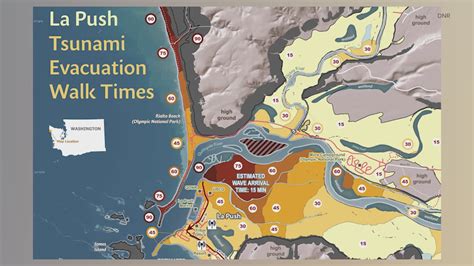
There is potential for machine learning models to be trained on SWOT datasets, allowing for faster and more precise tsunami detection based on real-time surface topography data. Coastal cities in tsunami-prone areas such as Japan, Indonesia, Chile, and the U.S. Pacific Northwest could benefit from earlier alerts and more targeted evacuation orders.
Conclusion: A Moment of Discovery and a Call for Continuity
The extraordinary data captured by NASA’s SWOT satellite stands as a pivotal moment in the study of tsunamis. It dismantles old assumptions, validates cutting-edge theories, and opens a path toward a safer, more informed world. But these scientific advancements do not exist in a vacuum—they require sustained investment, institutional stability, and a commitment to public good.
If policymakers fail to see the immediate value in missions like SWOT, we risk losing far more than research. We risk our ability to understand and protect the very planet we call home.
Tsunamis may be rare, but when they strike, they do so with overwhelming force. The tools to understand them—like SWOT—must not be allowed to disappear.


