
In the early summer of 2025, a cataclysmic geological upheaval unfolded off the coast of Russia’s Kamchatka Peninsula, shaking the planet with an 8.8-magnitude earthquake and giving rise to a colossal tsunami that surged across the Pacific Ocean. What makes this event historically significant is not merely the raw power it unleashed, but the groundbreaking satellite image captured by NASA’s Surface Water and Ocean Topography (SWOT) satellite—a visual moment that stunned scientists and defined a new era in geophysical monitoring.
Unprecedented Tsunami Event Captured from Orbit
While the Kamchatka Peninsula is no stranger to seismic activity, the 2025 event has etched itself into global memory due to the clarity and depth of satellite imagery it produced. The SWOT satellite, a collaboration between NASA and CNES (France’s National Centre for Space Studies), was launched in 2022 with the purpose of mapping Earth’s surface water. What it documented in June 2025 was nothing short of monumental: a tsunami wave that roared outward from the rupture zone, its energy visible from space.
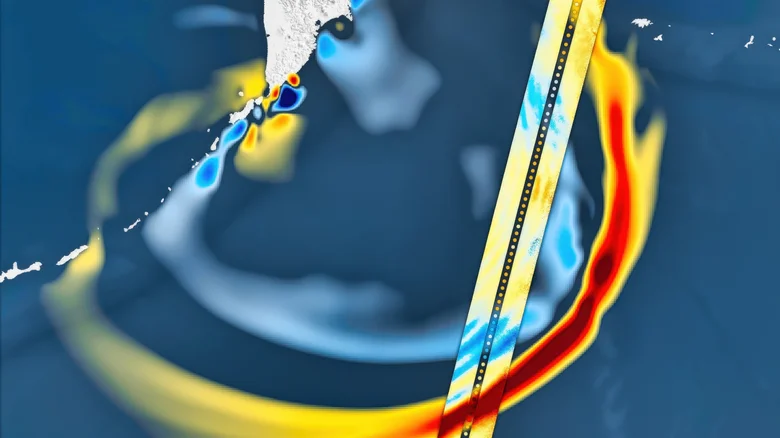
This wasn’t merely an image—it was an analytical breakthrough. The satellite recorded a 75-mile-wide swath of ocean, capturing the tsunami’s waveform in high-resolution three-dimensional detail. The wave pattern, seen racing across the sea surface, exposed nuances of ocean dynamics previously unattainable without direct observation. It is the largest seismic event the satellite has captured so far, and its data is redefining how we model undersea earthquakes and their oceanic aftermaths.
The Earthquake’s Violent Anatomy and the Birth of a Wave
According to the research published in The Seismic Record in November 2025, the rupture zone extended over 250 miles, with portions of the seafloor lifted by as much as 13 feet. This sudden vertical displacement of the ocean floor generated massive pressure changes that pushed an immense volume of water upward—thus birthing the tsunami. This mechanical translation of tectonic stress into oceanic movement unfolded within seconds, and the real-time monitoring by both satellite and buoy systems revealed it in exacting precision.
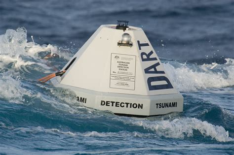
NASA’s SWOT satellite wasn’t the only player. The NOAA’s DART system (Deep-ocean Assessment and Reporting of Tsunamis), consisting of anchored sensors that monitor deep-sea pressure, also swung into action. These seafloor units transmitted live updates to surface buoys and satellites. Scientists used these readings to retroactively map the seafloor’s deformation, filtering out background ocean tides and isolating the seismic signal that initiated the tsunami.
Rewriting Tsunami Prediction Models
This event has forced a re-evaluation of long-standing tsunami hazard models. The 2025 Kamchatka quake followed another seismic event from 1952—a 9.0-magnitude earthquake originating from the same fault system. However, the 2025 quake occurred deeper below the Earth’s crust, and as such, did not result in comparable damage. Yet, the geological implications are sobering: the 1952 event had not fully released tectonic stress, meaning the fault remained volatile.
These insights challenge the traditional assumption that megaquakes recur over centuries. Instead, what researchers observed suggests a dangerously shorter recurrence interval, especially in subduction zones like Kamchatka, which are notorious for generating high-magnitude quakes.
SWOT’s Role in Tsunami Readiness and Response
The integration of SWOT satellite data into tsunami science is not just academic. The capability to rapidly acquire high-resolution spatial data of tsunami waves in real-time can drastically improve early-warning systems. When used in concert with buoy networks, SWOT enables faster and more accurate modeling of a tsunami’s potential landfall and severity.
By capturing the shape, size, and energy of the wave from space, emergency response teams can get more reliable forecasts to guide evacuations. In the 2025 event, such integration allowed for better prediction pathways, even though the tsunami ultimately did not inflict the widespread devastation that was feared.
The Future of Spaceborne Oceanography in Disaster Science
The success of SWOT during this disaster marks a new chapter in how we study Earth’s most violent phenomena. For the first time, scientists could observe a massive tsunami evolve with both temporal and spatial continuity, unlocking a wealth of oceanographic and seismological data.
Looking ahead, there are growing calls for expanded cooperation between satellite-based systems and coastal ground infrastructure. The dream is to create a comprehensive, real-time tsunami tracking architecture—one that can predict, detect, and communicate risk in seconds. With SWOT, that vision is moving closer to reality.
In the wake of this event, governments, scientific institutions, and international agencies are revisiting coastal policies, investing in improved detection networks, and training populations for swift evacuation. If anything, the 2025 Kamchatka tsunami—and the terrifying yet stunning image captured by NASA’s SWOT—has become a sobering emblem of nature’s force and the imperative of scientific vigilance.


