Height Monitoring Units, or HMUs, are ground-based systems designed to ensure the safe operation of aircraft in controlled airspace. Each HMU consists of two key components: the Height Monitoring Element (HME) and the Total Vertical Error Monitoring Unit (TMU). The HME captures transponder signals from aircraft responding to radar station interrogations. These signals include vital information from modes S, C, and A transmissions. By analyzing the time it takes for these signals to arrive at different receiver locations, the HME can determine the aircraft’s geometric height and position. This data is then sent to the TMU at a rate of one plot per second.
The TMU compiles this information to create a track history for each aircraft that flies through its coverage area. To enhance accuracy, this track data is combined with meteorological information to assess the Total Vertical Error (TVE). Once the monitoring process is complete, the HMU generates readings for TVE, Assigned Altitude Deviation (AAD), and Altimeter System Error (ASE) for each aircraft.
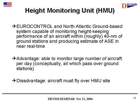
In Europe, the results from these Height Monitoring Units are automatically transmitted to the EUR RMA at EUROCONTROL Headquarters in Brussels. There, the data is verified and credited to approved aircraft and operators. EUROCONTROL operates three HMUs strategically placed to monitor busy air traffic areas without imposing any costs on operators. These locations include Linz in Austria, Nattenheim in Germany, and Geneva in Switzerland, each with a monitoring radius of 45 nautical miles.
In the North American region, the FAA has developed a similar ground-based monitoring system, although it differs significantly in design. Data sharing between Eurocontrol and the FAA shows that both systems yield comparable results for monitored aircraft.
For flights operating outside areas covered by ground-based systems, there is an alternative: the GPS Monitoring Unit (GMU). This portable system captures data directly from the aircraft, including GPS positional information. After the flight, the collected data can be processed using GPS differential corrections and meteorological data to analyze ASE characteristics. The GMU’s main advantage is its versatility, as it can function anywhere with available GPS corrections and weather data. However, it does require a skilled operator on board, leading to higher costs and limited monitoring results.
Lastly, ongoing investigations aim to develop practical height monitoring systems using ADS-B signals. This could potentially increase the number of aircraft that can be monitored at a much lower cost.

")
")

 and Decision Height (DH): Understanding the Differences and Their Importance in Aviation")


 System")
")