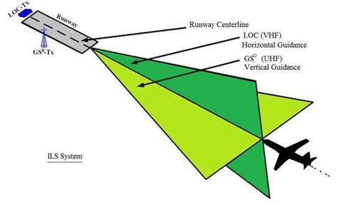
The Instrument Landing System (ILS) has remained the cornerstone of precision approach procedures for nearly a century. Among its critical components, the localizer stands as the primary source of horizontal guidance, helping aircraft align precisely with the runway centerline during the most critical phase of flight—landing. In this article, we examine the localizer range, how it functions, its technological framework, and its operational limits that ensure safe and accurate landings in reduced visibility conditions.
What is the Localizer in an ILS System?
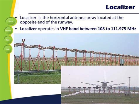
The localizer is a ground-based radio transmitter situated at the far end of a runway. Its role is to guide an aircraft laterally—left or right—onto the extended centerline of the runway. It accomplishes this by emitting two overlapping modulated frequencies, typically 90 Hz and 150 Hz, using a carrier frequency within the 108.10 MHz to 111.95 MHz range (odd tenths only).
ILS receivers aboard aircraft compare the difference in modulation depth between these two signals. When the aircraft is aligned with the runway centerline, the signals are received equally, prompting an “on-course” indication on cockpit instrumentation.
The adjusted course width of the localizer signal is about 700 feet wide at the runway threshold, creating a fly-left to fly-right full-scale deflection zone that allows for precise tracking along the intended approach path.
Localizer Range and Service Volume
The localizer’s range is one of the most critical performance characteristics that dictates its effective use in an ILS approach. Officially, the service volume of a localizer is segmented based on the aircraft’s angle relative to the runway centerline:
-
Within 10° of runway centerline: reliable signal coverage extends up to 18 nautical miles (NM).
-
Between 10° and 35° off centerline: signal coverage is limited to 10 NM.
This segmentation exists to prevent signal degradation and ensure that aircraft only receive precise guidance when within the designed cone of accuracy. Although pilots may technically detect localizer signals outside these bounds, those readings should not be trusted as they fall outside the guaranteed performance envelope.
Signal Behavior and Accuracy Dynamics
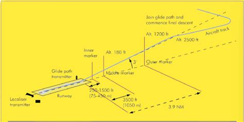
As the aircraft closes in on the runway, signal sensitivity increases dramatically. This means that small deviations from the centerline result in larger deflections on the instrument display. The narrowing signal cone demands finer control inputs from pilots, especially during Category I, II, or III approaches, where decision altitudes can be as low as 200 feet—or even lower in CAT III.
The high fidelity of the signal near the runway enables precision guidance during low-visibility operations, but it also requires careful pilot technique to avoid over-correcting. In modern glass cockpit displays, the localizer appears as a horizontal needle or bar, guiding pilots to “fly toward the needle” to stay aligned.
Frequency Allocation and Interference Protection
To preserve the integrity of ILS operations, localizer frequencies are tightly controlled and spaced to prevent mutual interference. Only odd-tenth channels within the 108.10 to 111.95 MHz range are allocated for ILS use, thereby segregating these from adjacent navigational aids like VORs. This ensures that pilots can trust the signals even in RF-dense terminal environments.
The localizer also includes a course width calibration, ensuring that regardless of the length of the runway or the surrounding terrain, the full-scale deflection is adjusted to remain consistent with expected approach tolerances. These adjustments are performed periodically by ground technicians using calibration aircraft and flight inspection procedures.
Integration with the ILS System
While the localizer governs horizontal alignment, it operates in conjunction with several other components:
-
Glideslope Antenna: Located beside the runway, it provides vertical descent guidance—usually at a 3-degree glidepath.
-
Marker Beacons: Positioned along the approach path, these transmit tones that inform pilots of critical points like the Final Approach Fix or Decision Height.
-
Approach Lighting Systems (ALS): These systems bridge the transition from instrument flying to visual reference by illuminating the runway centerline in low-visibility scenarios.
Together, these components form a precision landing environment that reduces pilot workload and enhances landing success rates in adverse weather.
False Localizer and Interference Concerns
Although uncommon, false localizer signals may be received due to signal reflection from large surfaces, buildings, or metallic aircraft near the antenna. These reflected beams can produce phantom indications off-axis from the actual course.
To mitigate such risks, modern ILS installations are constructed in cleared safety areas, and airport authorities maintain obstruction-free zones surrounding ILS equipment. Pilots, too, are trained to verify signal alignment with published approach plates and, when necessary, rely on secondary navigation aids such as DME or GPS overlays.
Maintenance and Operational Reliability
The localizer’s reliability is paramount to safe operations. These installations undergo routine calibration, where specially-equipped aircraft fly precision patterns to validate signal strength, modulation, and alignment. Technicians monitor signal integrity using ILS test sets, and any deviation prompts immediate maintenance intervention.
ILS ground facilities typically operate with redundant systems to prevent a single-point failure. Should the localizer malfunction, the ILS approach becomes unusable, and this status is immediately communicated via NOTAMs (Notices to Airmen) and ATIS (Automatic Terminal Information Service).
Role in Modern Aviation Navigation
Despite the evolution of satellite-based landing systems such as GBAS and WAAS-enabled LPV approaches, the ILS localizer remains the gold standard for Category II and III approaches. These procedures require extreme precision and are heavily regulated, making ground-based solutions with proven integrity and low latency indispensable.
In many high-traffic airports around the world, dual or triple ILS systems are employed, enabling parallel landings and complex approach sequencing. The reliability of the localizer makes it especially suitable for automatic landings performed by modern autopilot systems during low-visibility conditions, further cementing its role in the future of aviation.
Challenges in Localizer Deployment
Deploying and maintaining localizer systems involves complex site surveys, terrain assessments, and environmental evaluations. Surrounding geography must be analyzed to ensure clear signal propagation. Moreover, any topographical irregularity can lead to scalloping, a phenomenon where signal strength fluctuates along the approach path.
Airports located in mountainous terrain or urban areas often face limitations in positioning the localizer antenna in the optimal spot. In such cases, offset localizer approaches may be used, which require the pilot to transition visually to runway alignment at a later stage.
Conclusion
The localizer range in an ILS system is a critical metric defining the area in which an aircraft can reliably receive horizontal guidance. Understanding its technical boundaries, signal characteristics, and operational nuances is essential for any aviation professional involved in flight operations, ATC, or airport infrastructure. As we move toward integrated and augmented navigation systems, the localizer remains a vital tool, providing the precision and dependability necessary for safe landings under the most demanding conditions.
Frequently Asked Questions (FAQs)
What is the maximum range of a localizer signal?
The maximum usable range of a localizer signal is 18 nautical miles within 10 degrees of the runway centerline. Beyond 10 degrees and up to 35 degrees, the range is limited to 10 NM.
Can a pilot receive a localizer signal beyond its published range?
Yes, a pilot may detect the localizer signal beyond its guaranteed coverage area; however, these readings may not be accurate. Navigation decisions should only be made within the certified service volume.
Why does the localizer signal become more sensitive near the runway?
As the aircraft approaches the runway, the course width narrows, meaning even minor deviations from the centerline cause significant deflection on the indicator. This ensures high precision during final approach but also demands finer control adjustments from pilots.


")
")


")
