The Localizer is a cornerstone of modern aviation infrastructure, embedded deeply within the Instrument Landing System (ILS) used across global airfields. As a highly specialized navigational aid, the localizer provides lateral guidance to aircraft, enabling precision approaches and landings even under the most challenging weather conditions. Its technological refinement and integration with other ILS components have made it indispensable for maintaining safety, efficiency, and operational consistency in commercial and military aviation.
The Localizer’s Operational Principle
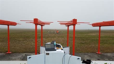
At its core, the localizer functions by emitting radio frequency signals that create a signal corridor aligned with the centerline of the runway. These signals are transmitted from a localizer antenna array, typically situated at the far end of the runway, directly opposite the landing direction.
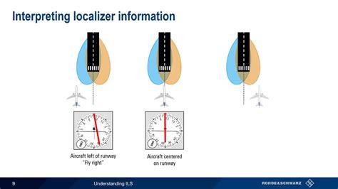
Aircraft equipped with appropriate VHF navigation receivers detect these signals and interpret their relative strength and phase difference to determine lateral position. This capability allows the cockpit instrumentation to present a Course Deviation Indicator (CDI), showing whether the aircraft is on course, left, or right of the optimal path.
This mechanism gives pilots real-time feedback, enabling continuous adjustments to maintain alignment during final approach. Unlike visual cues, which may be obscured during low visibility scenarios, the localizer’s signal is independent of weather, making it a primary reference for Category I, II, and III ILS approaches.
Precision in Lateral Guidance
The key function of the localizer is its ability to offer precise horizontal alignment with the runway’s centerline. This guidance is crucial during the final approach phase, where spatial orientation is critical, and any lateral deviation could compromise a safe touchdown.
Localizer signals operate typically in the 108.10 to 111.95 MHz frequency range, modulated with 90 Hz and 150 Hz tones. The difference in signal strength between these two tones as received by the aircraft’s antenna informs the aircraft’s position relative to the course. This level of precision translates to course widths of about 5 degrees, which can vary depending on runway configuration and the distance of the aircraft from the antenna.
Aircraft flying on course will receive equal signal strengths, keeping the CDI centered. As soon as the aircraft begins drifting to either side, the imbalance in modulation becomes apparent on the CDI, prompting corrective action by the flight crew.
Integration within the ILS Architecture
A fully functioning Instrument Landing System comprises multiple subsystems working in concert:
-
Localizer: Provides lateral alignment
-
Glide Slope: Delivers vertical descent guidance
-
Marker Beacons: Indicate specific distances from the runway threshold
-
Approach Lighting Systems (ALS): Offer visual cues during the final moments of descent
Together, these systems enable aircraft to follow an ideal approach trajectory, even during complete instrument meteorological conditions (IMC). While the glide slope handles vertical positioning, it is the localizer that keeps the aircraft on the centerline, an essential factor in reducing risks such as runway excursions or incursions.
In Category II and III landings, where visual cues are essentially nonexistent, the localizer becomes the definitive horizontal reference, trusted entirely by both pilots and autopilot systems.
Cockpit Interface and Pilot Workload
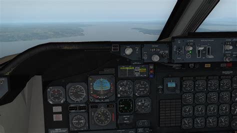
Pilots rely on Flight Director Systems (FDS) and Horizontal Situation Indicators (HSI) to receive and interpret localizer data. Upon intercepting the localizer beam, typically at a 30-degree angle or less, they monitor CDI deflections and apply corrective actions either manually or through autopilot engagement.
The instrumentation translates complex signal processing into a visual line representation, intuitively understood by pilots. A centered CDI indicates ideal tracking, whereas deflections to the left or right inform of deviations. Modern autopilot systems, particularly those with autoland capabilities, can lock onto the localizer signal and maintain alignment with extreme precision, ensuring a stable and safe approach path down to touchdown.
Safety and Efficiency Impact
The presence of a robust localizer system significantly boosts approach and landing safety. By removing ambiguity in lateral positioning, it minimizes:
-
Runway misalignments
-
Premature descents off-course
-
Collision risks during parallel runway operations
Moreover, it improves airspace throughput and supports dense airport operations, especially in low-visibility conditions, where visual approaches are unfeasible. Aircraft can land with shorter spacing intervals, optimizing airport capacity and reducing holding patterns during congested periods.

From a logistical standpoint, reliance on the localizer for standardized approaches also minimizes the need for diversions or go-arounds, contributing to reduced fuel burn, operational costs, and passenger delays.
Engineering Accuracy and Maintenance
The engineering behind localizer systems ensures sub-meter accuracy in lateral guidance. This is achieved through:
-
Highly directional antenna arrays, often composed of multiple radiating elements
-
Redundant monitoring systems to detect signal anomalies or degradation
-
Automatic changeover systems in case of component failure
Localizer systems undergo regular calibration by ground teams and flight inspection units, often using specially equipped aircraft. These flights evaluate signal integrity and conformity to ICAO Annex 10 standards, ensuring operational safety.
Because of their critical role, localizers are protected by protected zones, where no structure or vehicle is permitted to interfere with the signal propagation. Encroachment in these zones can distort beam integrity, leading to inaccurate guidance.
Air Traffic Control and Localizer Use
Air Traffic Controllers (ATC) play a vital role in sequencing aircraft for localizer approaches. They issue clearance for ILS approaches, specifying the runway and confirming that the localizer frequency has been correctly tuned in.
Controllers also monitor the aircraft’s trajectory on radar and offer corrective vectors if deviations are noted prior to intercept. Once the aircraft is established on the localizer, it is expected to maintain the course with minimal lateral correction.
In some terminal procedures, localizer-only approaches (LOC) are published, which use the lateral guidance from the localizer without the vertical component of the glide slope. These procedures are particularly useful for airports lacking full ILS capabilities or in terrain-challenged environments.
Future Evolution of Localizer Technology
Despite the rise of satellite-based navigation systems like GBAS (Ground-Based Augmentation System) and RNAV/RNP procedures, the localizer remains highly relevant. This is due to its:
-
Regulatory acceptance across all ICAO member states
-
Compatibility with all commercial aircraft
-
Proven reliability and cost-effective deployment
However, modernization efforts are underway to increase signal redundancy, introduce remote monitoring, and integrate with NextGen and SESAR air traffic management frameworks. These updates will ensure the localizer continues to serve as a high-availability fallback and primary tool in a hybrid navigation environment.
FAQs about Localizer Aviation
What is the difference between a localizer and a glide slope?
The localizer provides lateral guidance, helping aircraft align with the runway centerline horizontally. The glide slope, on the other hand, offers vertical descent guidance, ensuring the aircraft descends at the correct angle toward the runway.
Can aircraft land using only the localizer?
Yes, in procedures called localizer-only (LOC) approaches, pilots use just the lateral guidance from the localizer. These are non-precision approaches, typically used when the glide slope is unavailable or inoperative.
How accurate is the localizer signal?
The localizer is highly accurate, with lateral deviations of less than 3 meters at touchdown distances. This precision is vital for Category III approaches, where pilots rely exclusively on instrument guidance without external visual references.


 in Modern Travel")

