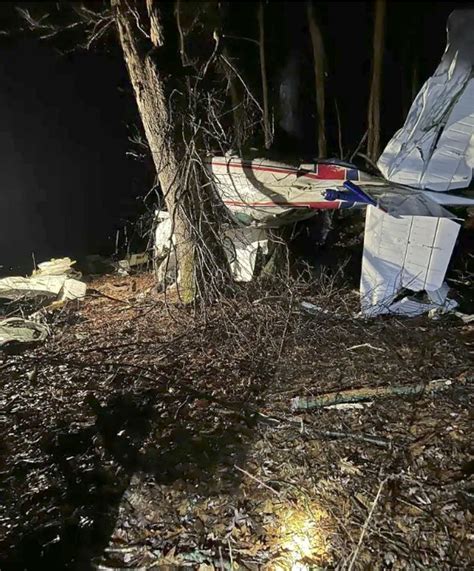
On the afternoon of October 20, 2023, a tragic aviation accident in Northern California claimed the lives of Vaughn Porter, a highly experienced JetBlue pilot, and his partner Jaime Redford Rust. The couple’s Beechcraft A36 Bonanza smashed into a rugged mountainside outside Covelo, a remote town in Mendocino County, raising unsettling questions about flight protocols, federal aviation guidance, and a legacy of oversight failures.
The crash occurred shortly after takeoff from Round Valley Airport. Despite clear weather conditions and no known mechanical failures, Porter deviated from the standard eastbound departure route and instead launched westward—directly into steep and unforgiving terrain. A sudden, steep banked turn moments later ended in a fatal impact, with investigators now pointing to a combination of pilot decision-making and Federal Aviation Administration (FAA) documentation gaps as key elements of the tragedy.
The Last Flight of a Veteran Aviator
Porter, 54, was no novice. A professional commercial pilot with a spotless record, he had spent thousands of hours in the air. For his son Kyle Porter, the crash made no sense. “He wasn’t a cowboy pilot,” Kyle insisted. “He always erred on the side of caution.”
On that day, Porter and Rust had departed from Heber Valley Airport in Utah, heading for Shelter Cove, a notoriously fog-prone airstrip along California’s Lost Coast. As clouds loomed over the coast and obscured Shelter Cove, Porter opted for a reroute. He refueled at Round Valley Airport and prepared for a short flight westward. But within moments of departure, the aircraft was in distress.
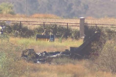
A witness described the aircraft’s left turn as steep—between 70 and 80 degrees. Then came a rapid descent. Seconds later, it slammed into a mountain slope and ignited in a fireball. Investigators from the National Transportation Safety Board (NTSB) later confirmed there were no signs of pre-impact mechanical failure or toxicological impairment.
A Puzzling Departure
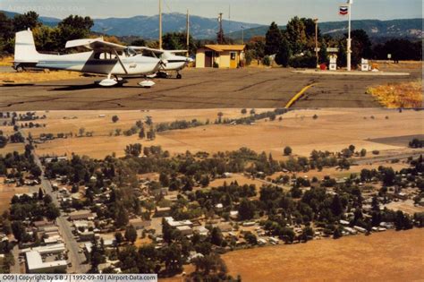
According to the NTSB’s final report, the primary cause of the crash was the pilot’s failure to maintain clearance from the trees after initiating a steep turn for unknown reasons. More concerning, however, was Porter’s choice to depart from Runway 28—a direction that leads straight into rising mountainous terrain—rather than Runway 10, which offers a departure over flat land.
What baffled aviation experts and investigators alike was the fact that Porter also executed a left turn, directly violating the right-hand traffic pattern recommended by FAA documentation for Covelo. While the skies were clear and wind negligible, this deviation from both standard protocol and Porter’s own history of caution remains deeply perplexing.
Even more troubling was the potential issue of runway length. Investigators speculated that Porter may not have used the full length of the 3,670-foot runway, instead departing from a taxiway near the fuel pumps. If so, he may have had only 2,400 feet for takeoff—possibly insufficient to gain safe altitude in such terrain.
FAA Documentation: A Fatal Blind Spot
What stands out most in the NTSB report is not just what Vaughn Porter did—but what he wasn’t warned about. The FAA’s Chart Supplement, a critical guide for pilots detailing airport layout and environmental hazards, was sharply criticized for lacking any mention of the 4,000-foot peaks just one nautical mile west of Runway 28.
The NTSB wrote unequivocally: the supplement “insufficiently described” the terrain. Pilots rely on these documents in tandem with sectional charts, but omissions like this are not trivial. A single line of text noting mountainous terrain could sway a pilot’s takeoff decision.
Since the crash, the FAA has updated the Covelo supplement. It now includes warnings about the valley’s surrounding terrain and strongly recommends mountain flying experience. This post-crash update underscores how outdated or incomplete data in official supplements can become lethal oversights.
Systemic Weaknesses in Rural Aviation Safety
Porter’s crash may be just one incident, but it draws attention to the FAA’s broader vulnerability: rural airports in Class G airspace. These low-altitude, uncontrolled zones operate without radar, towers, or mandatory communication. Pilots flying into such areas must rely on their own visual assessments, weather, and FAA-provided materials—materials that, as in Covelo’s case, may be lacking.
Peter Knudson, spokesperson for the NTSB, admitted that the Covelo documentation issue was not part of a broader study. “This was more of a ‘one off’ kind of finding,” he said, emphasizing that the agency isn’t resourced to conduct sweeping reviews of FAA materials nationwide.
This piecemeal approach to safety oversight has left some pilots and families, like the Porters, disillusioned. “It feels kind of two-faced,” Kyle Porter said. “The FAA claims safety is a priority, but their documentation didn’t reflect that.”
Visual Warnings vs. Paper Warnings
Some aviation professionals, like Frank Delosso, a veteran pilot familiar with Covelo, suggest that visual cues matter more than FAA text. “There’s a big mountain in front of you,” Delosso said plainly. “If you can’t see that, you shouldn’t be flying.”
But that approach assumes optimal visibility and ignores complex variables like fatigue, distraction, and limited local knowledge. For first-time visitors like Porter—despite his expertise—the lack of clear textual warnings about steep terrain may have compounded the danger.
Moreover, aviation charts are only useful when pilots reference them. FAA guidance expects pilots to cross-reference sectionals, supplements, and NOTAMs, but the real-world demands of backcountry flying often leave room for error. Pilots working outside controlled airspace in remote terrain face different challenges than those flying commercial routes at 30,000 feet.
Lessons From Tragedy: Can the System Change?
This crash illuminates a troubling question: How many more undocumented hazards exist across the FAA’s hundreds of rural airfields? With no comprehensive audit system in place, critical information may remain buried until tragedy forces a rewrite.
For the Porter family, the NTSB report—while valuable—does little to ease the grief. Kyle Porter mourns not only a father but a man who lived for flight and took every precaution. His frustration is sharpened by the knowledge that a small line of text in a government document might have saved two lives.

The FAA, for its part, maintains that its materials are structured to work in tandem. FAA spokesperson Cassandra Nolan reiterated that sectional charts—not supplements—are the primary tool for terrain awareness. But this siloed view of navigation documentation overlooks the complexity of modern flying.
Ultimately, the loss of Vaughn Porter and Jaime Rust is a stark reminder that in aviation, oversight gaps can be fatal. The incident underscores the urgent need for a system-wide reevaluation of how critical flight data is disseminated, especially for remote and high-risk airfields. Until then, pilots flying into rural valleys and mountain passes may continue to rely not just on skill and judgment—but on luck.


