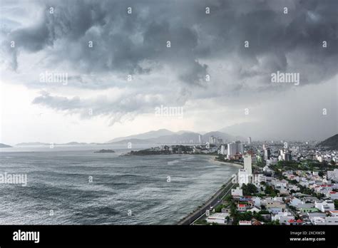
As Storm No. 3 approaches, Vietnam has implemented strict restrictions on sea travel and tourism to safeguard both residents and visitors in the affected coastal regions. This storm, expected to unleash strong winds and heavy rains, has prompted local authorities to suspend all beach visits and halt maritime activities, thereby ensuring public safety amidst the impending severe weather conditions. The proactive measures are a direct response to the escalating risk of widespread damage, as authorities in key coastal provinces such as Nghe An, Quang Ninh, and Hai Phong take decisive steps to protect lives and property.
In an urgent directive issued by the People’s Committee of Nghe An province, all forms of transportation, including boats, have been prohibited from venturing out to sea starting at 5:00 a.m. on July 21. This restriction is set to remain in place until the storm subsides. Additionally, vessels that are currently at sea must return to shore and anchor securely by 10:00 a.m. to avoid any potential mishaps during the storm. These measures are part of a broader effort to ensure the safety of both residents and tourists in a region renowned for its coastline and marine activities.
Similarly, Hai Phong, another critical coastal province, has taken precautionary steps by suspending all maritime and river activities since 5:00 p.m. on July 20. This suspension includes popular attractions like the Cat Hai – Phu Long cable car service, which is typically a major draw for tourists. The Hai Phong Department of Culture, Sports, and Tourism has instructed local tourist sites, accommodations, and travel businesses to closely monitor the storm’s progression. Tourists are advised to adjust their travel plans and avoid outdoor activities entirely during these adverse weather conditions. Furthermore, authorities have emphasized that guests should not be housed in vulnerable areas, particularly those prone to landslides and flooding.
In Quang Ninh, authorities have mandated that all passenger ships and tourist boats return to port by 6:00 p.m. on July 20, effectively halting any permits for vessels intending to leave the port. On the islands of Co To and Ngoc Vung, border guards have activated storm warning flares, a system that will remain in operation as the storm progresses. The Quang Ninh Department of Tourism is collaborating with local travel agencies to monitor tourist numbers, especially for those located on islands or at sea, ensuring they receive timely updates and instructions.
The city of Thanh Hoa has also imposed a sea ban commencing at 8:00 a.m. on July 21, which will persist until the storm has passed safely through the region. Likewise, Ninh Binh has suspended ferry services from 5:00 p.m. on July 21, instructing coastal areas to coordinate with the Border Guard to prevent vessels from leaving the shore by 7:00 a.m. and to seek shelter by noon the same day. These preventive measures are crucial to ensuring that no unnecessary risks are taken in light of the impending storm.
The storm’s impact extends to the southern part of the country as well. The Phu Quy Express high-speed ferry, which connects Ho Chi Minh City to Con Dao, has suspended its services from July 21 to July 24. Though this measure is temporary, it highlights the extensive effect of Storm No. 3 on Vietnam’s transportation infrastructure. In contrast, the Sa Ky – Ly Son route continues to operate normally, with local authorities reporting stable weather conditions on the island. The People’s Committee of Ly Son Special Zone in Quang Ngai has assured that they will keep monitoring the situation and implement necessary storm response measures as developments unfold.
In An Giang, the Department of Tourism has urged waterway tourism businesses to refrain from taking tourists to areas where strong winds and rough waves are anticipated, particularly during canoe excursions near islands. This proactive stance aims to prevent potential accidents and ensure the safety of tourists engaging in water-based activities.
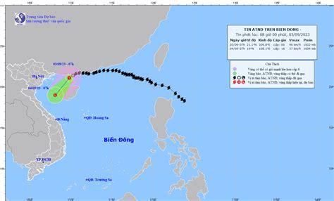
According to the National Center for Hydro-Meteorological Forecasting, Storm No. 3 is currently situated at 21.2 degrees North latitude and 109.6 degrees East longitude, approximately 190 kilometers away from Quang Ninh-Hai Phong and 310 kilometers from Hai Phong. The storm’s center is generating winds of level 9 (75-88 km/h) with gusts reaching level 11. As the storm progresses west-southwest at 10-15 km/h, coastal areas, particularly in Quang Ninh and Nghe An, will begin to experience the full force of strong winds starting the evening and night of July 21. These regions are forecasted to endure winds of levels 7-9, with gusts potentially reaching up to level 14 near the storm’s center. Such powerful winds are likely to cause significant damage, including uprooted trees, downed utility poles, and compromised roofs.
The storm is expected to make landfall in Vietnam on July 22, with Hung Yen and Thanh Hoa identified as focal points for its impact. As the situation evolves, local authorities remain committed to providing timely updates to ensure public safety.
As Storm No. 3 draws nearer, Vietnam has enacted stringent restrictions on sea travel and tourism to prioritize public safety. Coastal provinces are actively suspending maritime activities and beach visits in light of the anticipated severe weather, which includes strong winds and heavy rainfall. These measures aim to minimize risks and ensure the safety of both residents and tourists alike. For those planning to visit the affected coastal areas or engage in maritime activities in the coming days, it is crucial to reach out to tour operators in advance and remain vigilant by following updates from local authorities. This proactive approach will help mitigate risks and ensure a safer travel experience during this tumultuous period.


