The Wide Area Augmentation System (WAAS) enhances navigation accuracy by improving the Global Positioning System (GPS). Developed by the Federal Aviation Administration (FAA), WAAS covers most of the U.S. National Airspace System (NAS) and extends into parts of Canada and Mexico. It serves all types of aircraft during every flight phase, including departures, arrivals, and enroute navigation. Notably, it also supports vertically guided landings in Instrument Meteorological Conditions (IMC).
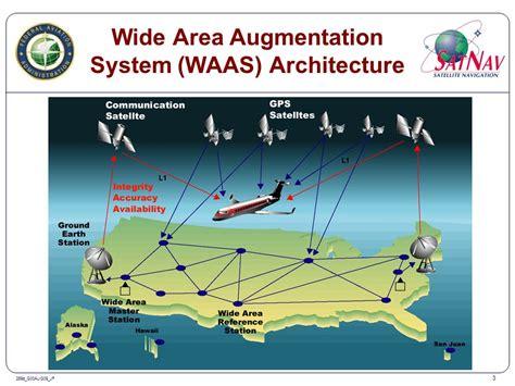
So, how does WAAS work? It spans nearly the entire U.S. NAS, providing vital augmentation data to GPS receivers. This boosts the accuracy and reliability of positioning. The process involves several steps. First, signals from GPS satellites are captured at various Wide Area Reference Stations (WRS) spread across the NAS. These WRS locations are meticulously surveyed to identify any errors in the GPS signals.
Next, the GPS data collected by these WRS sites is sent to the WAAS Master Station (WMS) using a land-based communication network. The WMS analyzes this information and generates WAAS augmentation messages. These messages are then transmitted from the WMS to uplink stations, which relay them to geostationary communications satellites. Finally, these satellites broadcast the augmentation messages via GPS-like signals. This allows aircraft GPS/WAAS receivers to correct errors in the GPS signal, significantly improving location accuracy and reliability. Additionally, WAAS informs GPS/WAAS receivers when the GPS system may be unreliable due to errors or other issues.
The benefits of WAAS extend beyond aviation, but it plays a crucial role in enhancing flight safety and efficiency. Here are some key advantages for aviation users: First, safety is paramount; WAAS adheres to stringent safety standards, alerting users within six seconds if the GPS provides misleading information that could lead to errors in position estimation. Second, position accuracy is notably improved, both horizontally and vertically. Third, where permitted, WAAS enables RNAV (GPS) approaches with Localizer Performance with Vertical guidance (LPV) minimums as low as 200 feet, comparable to ILS Category 1 capabilities. The number of WAAS-enabled LPV approaches has surpassed the number of ILS installations in the U.S. NAS. Additionally, WAAS supports Required Navigation Performance (RNP) values as low as 0.3 across North and South America. Lastly, WAAS is interoperable with similar Satellite-Based Augmentation Systems (SBAS) in Europe, Japan, and India, allowing WAAS-equipped aircraft to utilize these systems too.
")
")
")
")
")


