
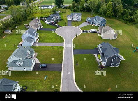
The evolution of aerial surveillance doctrine under the Fourth Amendment of the U.S. Constitution represents a collision of privacy rights and technological advances. The doctrine has historically allowed for warrantless surveillance from the air, justified by the principle that what is visible from public airspace is not protected by reasonable expectations of privacy. However, as surveillance technologies become more invasive, legal challenges increasingly question the boundaries of this constitutional interpretation.
At its core, the doctrine hinges on whether aerial observation constitutes a “search.” The U.S. Supreme Court has addressed this issue in landmark cases, establishing nuanced criteria to determine when aerial surveillance crosses constitutional lines. Among the critical factors considered by courts are the type of property surveilled, the technology used, the altitude and vantage point, and the extent and duration of the observation.
The Foundational Case: California v. Ciraolo (1986)
The inception of the aerial surveillance doctrine in modern jurisprudence began with California v. Ciraolo, where the Supreme Court ruled that law enforcement officers flying a private plane at 1,000 feet to observe marijuana plants in a backyard did not constitute a search. The majority held that the officers were in public navigable airspace, observing with the naked eye, and thus the defendant had no reasonable expectation of privacy.
Justice Powell’s dissent cautioned against the trivialization of privacy, arguing that an isolated flyover by a random passenger differs significantly from targeted law enforcement surveillance. Nonetheless, the precedent was set: aerial observations from legal altitudes using unaided vision do not violate the Fourth Amendment.
Commercial Property and Precision Photography: Dow Chemical Co. v. United States (1986)
Decided the same day as Ciraolo, Dow Chemical Co. v. United States tested the doctrine in a commercial context. Here, the EPA used a precision aerial mapping camera to photograph Dow’s sprawling industrial facility from various altitudes. The Court ruled that since the photos did not reveal “intimate details” and the property was commercial, no warrant was required.
The dissent again voiced concern, focusing on how the surveillance penetrated a protected commercial enclave and revealed confidential industrial data. But the ruling cemented another key distinction: commercial properties receive a lesser expectation of privacy than private homes.
Florida v. Riley (1989): Helicopters and Navigable Airspace
In Florida v. Riley, a helicopter hovering at 400 feet peered into a greenhouse where marijuana was being cultivated. The Court’s plurality decision extended Ciraolo’s logic: since helicopters could legally fly at that altitude, and the officer’s view was unobstructed, no Fourth Amendment violation occurred.
However, Justice O’Connor’s concurring opinion offered a critical perspective. She stressed that FAA compliance alone was insufficient to determine constitutionality and argued for a more context-driven approach rooted in whether the public commonly traversed the same airspace.

Judicial Fragmentation and the Factors Courts Weigh
The cases established a framework but not a formula. Courts now weigh several variables:
- Altitude and legality of flight (e.g., public navigable airspace)
- Technology used (naked eye vs. thermal imaging, drones)
- Target of surveillance (residential vs. commercial)
- Duration of surveillance (brief flyover vs. prolonged observation)
- Scope and intrusiveness (general view vs. peering into windows)
As technologies evolve, so too does the challenge of assessing privacy expectations in a society where aerial observation is increasingly automated, precise, and omnipresent.
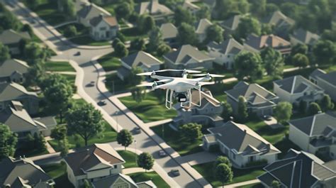
Modern Legal Battles: The Rise of Drones and Persistent Surveillance
The judicial landscape shifted dramatically with novel technologies like drones and high-resolution, persistent surveillance systems. These tools blurred the line between what’s visible and what’s invasive, raising the stakes of Fourth Amendment interpretations.
Dircks v. Indiana Department of Child Services (2022)
In Dircks, a drone flown outside law enforcement’s line of sight hovered near windows and outbuildings, triggering legal alarm. Unlike planes and helicopters in prior cases, the drone’s unique ability to enter intimate spaces at low altitudes pushed the court to diverge from Supreme Court precedent. The court ruled that the plaintiffs plausibly alleged a violation of their reasonable expectation of privacy.
This case signals a broader judicial recognition that drones are not just smaller aircraft. Their maneuverability, stealth, and persistence demand tailored constitutional scrutiny.
Leaders of a Beautiful Struggle v. Baltimore Police Department (2021)
A watershed moment arrived with Leaders of a Beautiful Struggle, where the court evaluated Baltimore’s AIR program: surveillance planes recording public movement over time. The Fourth Circuit emphasized the shift from mere aerial observation to comprehensive movement tracking, citing Carpenter v. United States as the governing precedent.
Here, the concern was not the surveillance altitude or method, but what the aggregation of data revealed: patterns of life, associations, and identities. The ruling reflected a modern understanding that data accumulation over time can constitute a search, even if individual snapshots do not.
The Emerging Legal Tension: Precedent vs. Innovation
What emerges from this evolving jurisprudence is a legal tug-of-war. On one side lies longstanding doctrine permitting aerial observation under narrow parameters. On the other, technological advancements challenge those very parameters, creating gray zones where expectations of privacy are redefined in real time.
The aerial surveillance doctrine now rests on increasingly precarious ground. Courts must ask: Does a drone hovering outside a bedroom window, even at a lawful altitude, honor the spirit of the Fourth Amendment? Does persistent observation turn surveillance from passive to invasive? What threshold of data aggregation becomes unconstitutional scrutiny?
These questions underscore a fundamental shift. Surveillance is no longer episodic—it’s constant, automated, and precise. The airspace above no longer carries just the random gaze of a passing pilot but the deliberate lens of state observation.
Legislative Interventions: States Draw the Line
Recognizing the lag between judicial response and technological change, many states have moved proactively. Sixteen states, including Alaska, Texas, and Florida, have enacted laws requiring law enforcement to obtain a warrant before deploying drones for surveillance purposes.
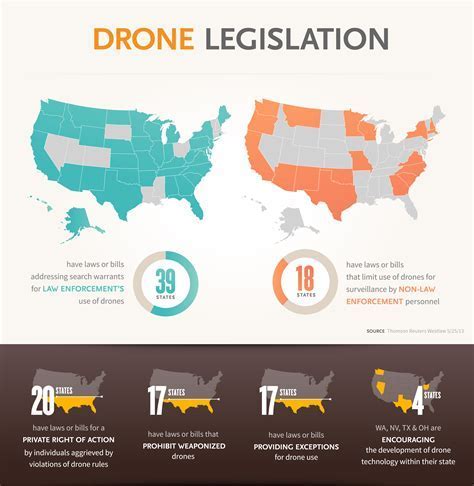
These statutes establish bright-line rules often absent in judicial rulings. They reaffirm the principle that privacy in the digital age must be protected by both courts and legislatures. However, a patchwork of laws creates inconsistency, leaving some citizens far more protected than others, based solely on geography.
The Road Ahead: Toward a Unified Surveillance Standard
The aerial surveillance doctrine is at a crossroads. The path forward demands a synthesis of precedent and progress, where courts balance the sanctity of individual privacy with the needs of law enforcement.
To create a coherent standard, future courts may need to:
- Acknowledge the distinct nature of drone technology
- Establish clear criteria for duration and depth of surveillance
- Recognize aggregation of data as a constitutionally significant factor
- Move beyond altitude-based rules to more holistic, context-driven tests
As surveillance becomes more deeply embedded in urban and rural airspace alike, the constitutional boundaries of aerial observation will continue to evolve. The challenge for the judiciary is not only to interpret the law, but to ensure that constitutional protections remain robust in a world where observation from above is no longer an exception, but the norm.
Privacy was once marked by fences and walls. In the 21st century, it may be defined by altitude, sensors, and flight paths. The aerial surveillance doctrine, once a niche legal principle, now sits at the heart of America’s most pressing civil liberties debates.


