An altimeter is one of the most indispensable instruments in both aviation and geospatial science, responsible for measuring altitude—the vertical distance between a reference level, typically sea level, and an object in the atmosphere or space. While the concept is mechanically simple, the altimeter plays a vital role in navigation, cartography, meteorology, and climate science, with applications ranging from jet cockpits and spacecraft to weather satellites and even the wrists of mountain climbers. Understanding the intricacies of altimeters requires an examination of their types, working principles, and importance across multiple fields.
Understanding the Principle: Altitude and Atmospheric Pressure
Altitude and atmospheric pressure are inversely related. As one ascends in the atmosphere, the density of air decreases, resulting in a measurable drop in pressure. This is the basic principle behind the most common type of altimeter: the barometric altimeter. It uses the static pressure of the atmosphere to calculate altitude, offering real-time feedback in aviation and climbing.
This pressure-altitude relationship is calibrated based on the International Standard Atmosphere (ISA), a theoretical model that represents average pressure, temperature, and density at different altitudes. However, environmental factors such as storms or temperature inversions can introduce slight deviations in actual readings, requiring pilots to frequently recalibrate instruments based on local atmospheric pressure readings.
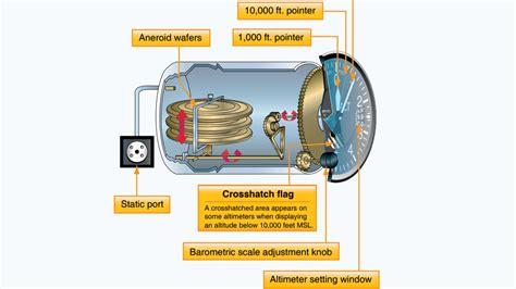
Barometric Altimeters: Anatomy and Functionality
A standard barometric altimeter consists of a sealed aneroid capsule, typically made from flexible metal. As the aircraft or climber gains altitude, the external air pressure drops, causing the capsule to expand. A mechanical linkage translates this deformation into pointer movements across a dial, which indicates altitude. When descending, the process is reversed as increasing pressure compresses the capsule.
These altimeters can be analog or digital:
- Analog altimeters display altitude using rotating dials and needles.
- Digital barometric altimeters often include pressure trend graphs and memory storage to track elevation changes over time.
Barometric altimeters are generally accurate within 20 to 30 feet when calibrated correctly, though errors may occur during rapid weather changes. This has led to the integration of GPS and radar systems in modern aircraft for enhanced accuracy.
GPS Altimeters: Satellite-Based Elevation Data
GPS altimeters represent a revolutionary leap in elevation measurement by relying on signals from at least four satellites to triangulate both horizontal and vertical positions. Unlike barometric altimeters, which are affected by local weather and pressure, GPS systems provide absolute altitude data. However, the vertical accuracy of GPS is generally lower than its horizontal precision, often varying by up to 10 meters depending on the signal quality and number of satellites in view.
Despite this limitation, GPS altimeters are widely used in:
- Geographic Information Systems (GIS)
- Smartwatches and fitness trackers
- Aircraft backup systems
- Search and rescue missions
Modern devices often combine barometric and GPS altimetry to deliver more accurate, stable altitude readings by compensating for each method’s weaknesses.
Radar and Laser Altimeters: Precision via Echo Timing
For high-precision tasks like terrain mapping, space exploration, or oceanography, radar and laser altimeters are the tools of choice. These instruments emit pulses of energy—radio waves in radar, laser beams in laser altimetry—and measure the time delay between emission and the signal’s return after bouncing off a surface. This time is then converted into distance using the known speed of light.
Radar and laser altimeters can be found in:
- Commercial airliners and military jets for low-altitude flight control
- Spacecraft and satellites like NASA’s TOPEX/Poseidon and Jason missions
- Topographical survey equipment for creating Digital Elevation Models (DEMs)
The TOPEX/Poseidon satellite, launched by NASA and CNES, revolutionized Earth observation by achieving sea surface height measurements accurate to within two centimeters. It helped track global sea level rise, providing empirical proof of climate change and supporting predictive climate modeling.
Altimeters in Aerospace Navigation and Safety
In aviation, altimeters are not just instruments—they are lifesaving tools. Pilots rely on altimeters for maintaining safe separation from terrain, managing vertical navigation during instrument flight, and ensuring compliance with air traffic control instructions.
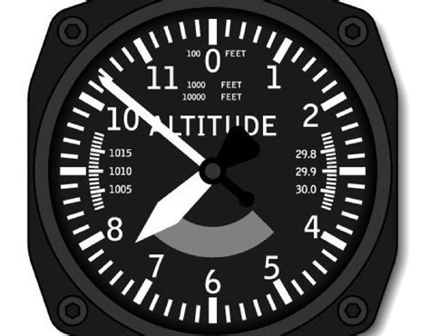
There are three types of altitude commonly referenced:
- Indicated Altitude: Read directly from the altimeter.
- True Altitude: Actual height above mean sea level (MSL).
- Pressure Altitude: Altitude above the standard datum plane of 29.92 inches of mercury (inHg).
Errors in altimeter readings can be catastrophic. For example, if an aircraft flies into an area of lower pressure without adjusting the altimeter setting, it may be flying lower than the indicated altitude, risking controlled flight into terrain (CFIT). For this reason, Altimeter Setting Procedures (ASPs) are globally standardized and mandated before takeoff, during cruise, and at descent.
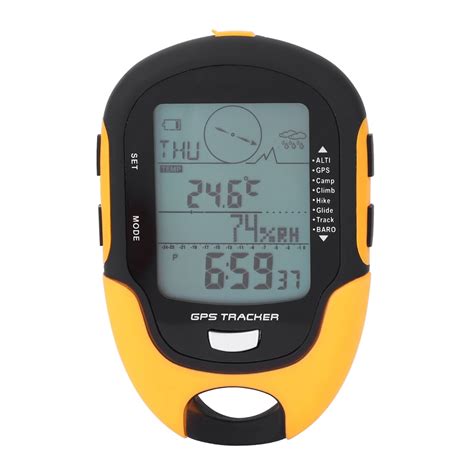
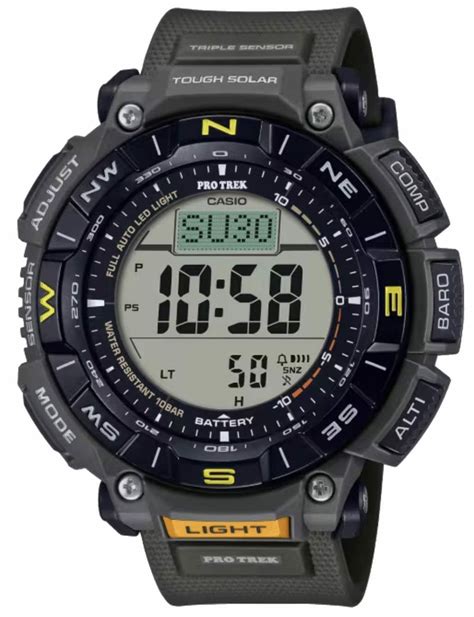
Wearable Altimeters and Recreational Use
Altimeters are no longer confined to cockpits or satellites. Mountaineers, skydivers, paragliders, and even hikers rely on wearable altimeters to track elevation gain, estimate time-to-peak, and assess oxygen availability. Many watches now incorporate barometric sensors, GPS chips, and even automatic weather alerts triggered by pressure drops.
These devices often come with features like:
- Altitude alarms for critical thresholds
- Climb rate indicators
- Temperature-compensated readings
- Altitude logging for performance tracking
Altimetry in Scientific Research and Environmental Monitoring
Beyond transportation and recreation, altimeters are indispensable in climate science, oceanography, and glaciology. Satellite-based altimetry allows researchers to monitor trends like:
- Melting glaciers and ice sheets in Antarctica and Greenland
- Thermal expansion of ocean water due to global warming
- Volcanic deformation through surface elevation changes
- River flooding patterns in real time using radar data
The data derived from altimetry is integrated into climate models to predict future scenarios. For instance, Jason-3 and Sentinel-6 satellites continue to collect data on global mean sea level—a key climate change indicator used by the Intergovernmental Panel on Climate Change (IPCC).
Future Trends: Quantum and LIDAR Altimetry
Emerging technologies promise to redefine altimetry. Quantum altimeters under development use atomic interference to measure altitude with extreme precision, free from environmental distortion. Meanwhile, LIDAR (Light Detection and Ranging) systems are becoming more compact and are now used on drones and autonomous vehicles for real-time terrain mapping and obstacle detection.
Future altimeters are expected to offer:
- Sub-centimeter vertical accuracy
- Integration with AI for autonomous decision-making
- Miniaturization for IoT and micro-drones
These innovations will expand altimeter applications to include urban planning, autonomous vehicles, and even medical altitude monitoring for patients with respiratory conditions.
Conclusion: The Elevation of Precision
The altimeter, despite its small size, embodies the intersection of physics, engineering, and data science. From analog pressure-based dials in 20th-century cockpits to space-borne radar arrays mapping the planet’s oceans, the evolution of altimetry reflects humankind’s relentless pursuit of precision and understanding of our vertical environment.
As the climate crisis intensifies and technology advances, the role of altimeters will only grow in significance. Whether guiding jets through turbulent skies or monitoring millimeter shifts in glacial ice, altimeters elevate our capabilities, helping us navigate, explore, and safeguard the world.


