
Flight following is a critical service offered by Air Traffic Control (ATC) to pilots operating under Visual Flight Rules (VFR). This optional service provides radar traffic advisories and situational awareness, enhancing both efficiency and safety in the national airspace. Pilots often rely on this service while en route, particularly during sightseeing flights, training maneuvers, or when transitioning from uncontrolled airspace to controlled regions. However, a common challenge arises: how to locate the correct frequency for initiating flight following when already airborne or maneuvering in less familiar airspace.
The Importance of Sectional Charts for Locating Frequencies
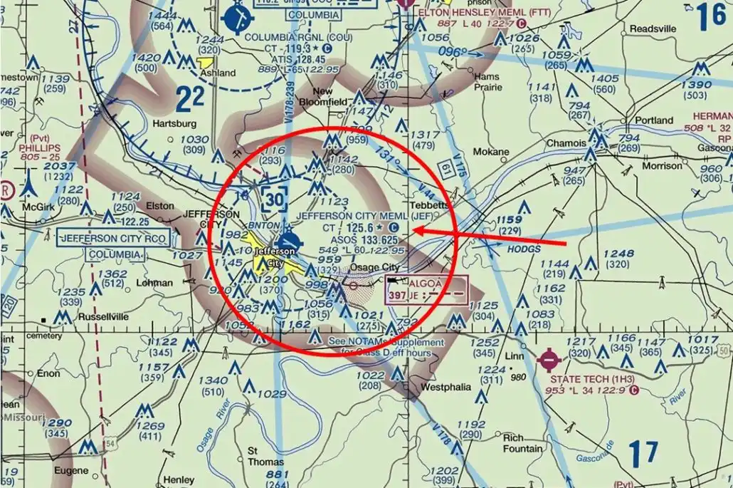
The most widely used tool for identifying flight following frequencies is the VFR Sectional Chart. These charts are designed to be incredibly information-dense, catering specifically to the needs of VFR pilots. Embedded within them are details about ATC services, including communication frequencies, navigation aids, topography, and airspace boundaries.
To find the right frequency:
- Locate your current position or area of interest on the sectional chart.
- Identify nearby Class B, C, or D airports, or other significant navigational or airspace landmarks.
- Look for frequency boxes, often placed adjacent to terminal control areas (TCA) or near busy airport environments. These boxes typically contain information for Approach Control, which is the relevant ATC facility to contact for flight following.
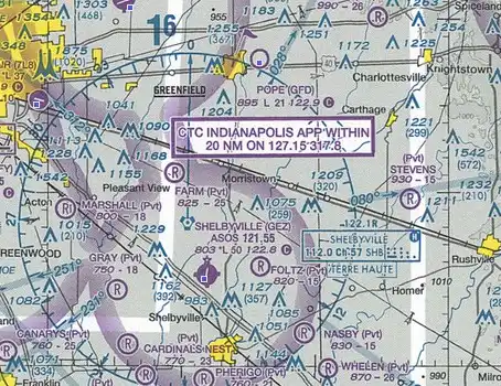
These boxes might appear crowded, but they’re well-structured. They include frequencies for various sectors of Approach Control, often divided by quadrants (e.g., NE, SW, etc.). For example, when departing from or flying near the San Francisco Bay Area, a sectional chart might display NORCAL Approach frequencies, but a more detailed analysis reveals that Travis Approach is responsible for a significant portion of airspace within that region.
Using Chart Tabs for Better Detail
While frequency boxes are useful, chart tabs offer even more comprehensive information. Tabs provide:
- Sector-specific frequencies with directional indicators (e.g., East of Runway 18R: 119.7 MHz)
- Operating hours, helping pilots know when services are active
- Details on military radar coverage, which is valuable when flying near bases
These tabs are usually located along the edges of sectional charts, labeled with airport names and corresponding data. Especially when flying near Class C or Class B airspace, chart tabs should be the first reference point for frequency information. If a frequency isn’t listed in the white ATC box, a quick glance at the tab may reveal the appropriate contact.
What If You’re Not Near Major Airspace?
Sometimes, pilots may find themselves in remote areas, far from major airports or radar coverage sectors. In these cases, the best strategy is to contact a Center controller. The appropriate frequencies are listed in several key resources:
- IFR En Route Low Altitude Charts: Even though intended for instrument navigation, these charts display ARTCC (Air Route Traffic Control Center) frequencies covering vast regions.
- Chart Supplement (formerly Airport/Facility Directory): Every published airport includes data on controlling agencies and communication frequencies, even if it’s an uncontrolled field.
- Flight Watch (122.0 MHz): Though decommissioned in its original form, the 122.0 MHz frequency still routes to Flight Service Stations (FSS) in many areas. Pilots can use it to ask for nearby Center or Approach frequencies.
The key is to announce your position clearly and wait. An example interaction might be:
“Flightwatch, Cessna 5180Z, 10 miles south of Crazy Woman VOR, request radar advisory frequency.”
Flightwatch will then provide the ARTCC frequency for the relevant sector, such as:
“5180Z, contact Salt Lake Center on 135.75.”
GPS and EFBs: Digital Tools with Frequency Access
Modern Electronic Flight Bags (EFBs) such as ForeFlight or Garmin Pilot provide real-time, location-based ATC data, including frequencies. Similarly, most GPS units in the cockpit offer a “nearest” function, which lists frequencies for the closest FSS, ATIS, CTAF, and ATC facilities. This can be invaluable when you’re on the move and need a quick solution without poring over charts.
Still, the printed chart remains authoritative, and it’s always advisable to cross-check the digital output with the charted data, particularly during preflight planning.
Knowing Which Facility to Contact
Understanding who to call is just as critical as knowing what frequency to use. The United States airspace structure is composed of:
- TRACON (Terminal Radar Approach Control) facilities, responsible for approach/departure within 30–50 miles of major airports
- ARTCC (Air Route Traffic Control Centers), which manage en route traffic across broad regions
If you are flying within proximity of controlled airports or under the Mode C veil of Class B or C airspace, your best bet is to contact the local Approach Control. These facilities are more attuned to low-altitude, VFR traffic.
Outside of these areas, particularly above 3,000–5,000 feet AGL or in rural zones, the Center frequency becomes the appropriate choice. Centers can initiate flight following, assign a squawk code, and maintain radar contact.
How ATC Assists During Flight Following
Once in contact, ATC provides real-time information and advisories that can prove vital to a VFR flight. Services typically include:
- Traffic advisories, especially in congested corridors
- Airspace alerts, such as upcoming TFRs or restricted zones
- Altitude guidance when transitioning across airspace boundaries
- Weather updates, if requested
Initiating contact clearly and professionally increases your chances of being accepted for flight following. Use standard phraseology:
“Approach, Cessna 4182K, 10 miles southeast of Raleigh-Durham at 3,500 feet, request VFR flight following to Charleston.”
The controller will respond with a squawk code and, if traffic allows, initiate radar service.
Limitations and Considerations
It’s important to note that flight following is provided on a workload-permitting basis. ATC may deny or terminate the service at any time. Pilots should also be aware of the following:
- Controllers may instruct you to contact another frequency as you transition through sectors
- If flying VFR cross-country, especially through several regions, prepare a list of potential frequencies in advance
- Always monitor guard frequency (121.5 MHz) as a backup
A good pilot is proactive, not reactive. Flight following not only improves safety but can also be invaluable in emergency scenarios, where already being in contact with ATC accelerates response and coordination.
Final Thoughts: Making the Most of Flight Following
Knowing how to find the correct frequency for flight following starts with being familiar with the available tools: sectional charts, chart tabs, en route IFR charts, and digital avionics. However, it also involves understanding airspace structure, communication protocols, and ATC expectations. Every VFR pilot, whether student or experienced, benefits from mastering these details.
Being able to quickly identify the nearest controlling agency’s frequency—even mid-flight—can significantly enhance the flight experience. It builds confidence, maintains safety margins, and opens the door to professional-level situational awareness.
In short, flight following isn’t just an optional service—it’s a smart pilot’s silent co-pilot.


