Last Point of Diversion (LPD)
Definition
A Last Point of Diversion (LPD) is crucial to calculate under specific conditions. You may need to determine it if your destination is an isolated airfield or if there’s uncertainty about landing at your intended destination or alternate airfield. The LPD represents the farthest point along your flight path where you can divert to a nearby airfield while still having a safe fuel reserve.
Graphical Solution
Here’s a step-by-step graphical method to find the Last Point of Diversion:
-
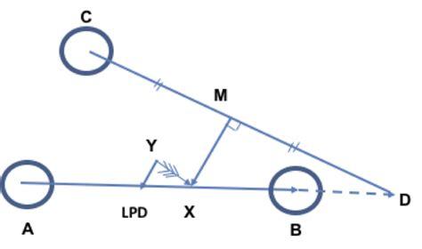
Continue your flight path from point A through point B, extending to point D where you reach your safe fuel reserves. Use True Airspeed (TAS) to find the distance in still air, with wind considerations later.
-
Draw a line from C to D and create the perpendicular bisector. This line intersects your flight path at point X, which is your still-air LPD since DX equals CX.
-
Measure the distance CX and divide it by TAS to determine the time.
-
Construct a wind vector from Y to X, ensuring its length corresponds to the calculated time (Length YX (Nm) = Wind speed (Kts) x CX (hrs)).
-
From point Y, draw a line parallel to MX. The intersection of this line with track AB gives you the wind-corrected LPD to C between points A and B.
Fuel Graph Method
This practical approach helps you calculate an LPD while in flight:
-
Inspect your route and fuel plan to estimate the LPD position (within about 300 nautical miles is acceptable).
-
Identify an en-route waypoint before your estimated LPD and measure the distances to both your destination and the alternate airfield.
-
Estimate the Fuel on Board (FOB) at the chosen waypoint. You should see a trend in fuel usage based on your previous checks.
-
Add the Zero Fuel Weight (ZFW) to the Estimated FOB to get an estimated All-Up Weight (AUW).
-
Choose the optimal flight level for diversion based on your AUW and IFR constraints.
-
Use the forecast wind chart to estimate the average wind component at the diversion altitude from the waypoint to the diversion.
-
Refer to the Flight Manual Performance Data to calculate TAS and fuel flow for your AUW and diversion flight level. If needed, you can calculate a mid-point weight for more accuracy, but it likely won’t significantly affect the final LPD unless the diversion leg is long.
-
Calculate groundspeed to the diversion using TAS and the average wind component.
-
Use this groundspeed and the distance to the diversion to find the time needed to reach it.
-
Multiply the time to diversion by the fuel flow to determine fuel burn. Add a 5% contingency to this figure for a corrected fuel burn.
-
Establish the minimum fuel required at the diversion airfield and add this to the corrected fuel burn to get the total fuel needed for the diversion from your selected waypoint.
-
Repeat steps 2-11 for at least three points around your estimated LPD position.
-
On graph paper, plot ‘fuel on board’ against ‘distance to destination’ to create a line representing fuel to destination (this should be roughly straight).
-
On the same graph, plot ‘total fuel to diversion’ against ‘distance to destination’ for a line that reflects fuel to diversion (this may not be straight unless the diversion is close to your track).
The point where the ‘fuel to destination’ line intersects with the ‘fuel to diversion’ line indicates the LPD.


