A massive volcanic eruption at Mount Semeru in East Java, Indonesia, has triggered a “Code Red” aviation warning from Australia’s Darwin Volcanic Ash Advisory Centre (VAAC). The alert follows the sudden escalation of seismic activity from Indonesia’s tallest and among its most volatile volcanoes, with eruptive columns of ash surging high into the stratosphere. The towering plumes, laced with sulfur dioxide and fine volcanic ash, have thrown aviation authorities into high alert, as the dangerous particles spread across flight corridors crucial to Southeast Asia and Australia.
The Semeru Eruption: A Seismic Wake-Up Call
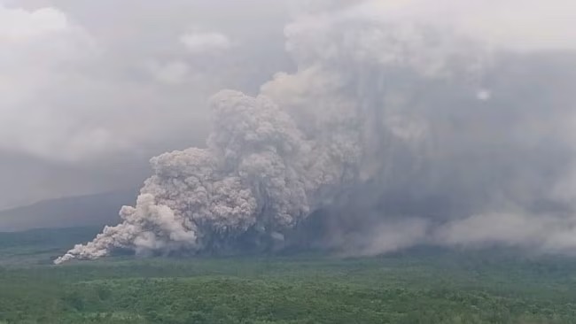
Semeru’s latest eruption phase began on November 19, marking a dramatic intensification of volcanic behavior. Plumes of ash reached heights up to 54,000 feet (16,500 meters), significantly higher than the standard cruising altitude of commercial aircraft. According to Indonesia’s volcanology agency, this activity marks one of the most severe episodes since the 2021 eruption, which claimed dozens of lives and razed several villages.
As lava and pyroclastic flows raced down the southern slopes, Indonesian authorities expanded the danger zone around the volcano and evacuated more than 300 residents from vulnerable communities. The scenes on the ground are once again harrowing, as entire neighborhoods are cloaked in ash and tremors shake the volcanic slopes.
Code Red: What the Aviation Warning Really Means
The Darwin VAAC’s “Code Red” status is the highest-level aviation alert issued for volcanic activity. It signals that ash is present in airspace and poses a significant danger to aircraft. This warning is not merely advisory—it prompts immediate route changes, altitude adjustments, or flight cancellations to ensure safety.
Ash clouds are notoriously perilous to modern aircraft. The abrasive particles can sandblast cockpit windows and airframes. Worse still, volcanic ash can melt inside jet engines, then resolidify, causing engine flameouts or even complete power loss mid-air. These risks are so severe that the International Civil Aviation Organization (ICAO) mandates that pilots avoid any visible ash at all costs.
Mapping the Danger: How VAAC Responds
The Darwin Volcanic Ash Advisory Centre, operated by Australia’s Bureau of Meteorology, monitors volcanic ash threats throughout Southeast Asia and parts of the southern hemisphere. Using satellite imagery, pilot reports, and seismic data, the VAAC traces the movement and altitude of ash clouds. It then publishes real-time graphics and bulletins that airlines use to divert routes and delay takeoffs.
In this case, several airways connecting Australia, Indonesia, Malaysia, and Singapore have been impacted. Air traffic controllers are working around the clock to reroute long-haul and regional flights, particularly those to and from Bali, Jakarta, and Darwin. In extreme cases, flight paths are adjusted to fly through alternate air corridors, or flights are simply grounded until the ash disperses.
A Wider Risk Zone Across the Pacific Rim
Semeru is one of many volcanoes strung along Indonesia’s Pacific Ring of Fire, a geologically unstable region where tectonic plates clash, generating frequent earthquakes and eruptions. Its repeated activity—combined with eruptions from neighboring volcanoes like Mount Merapi and Mount Sinabung—poses a systemic threat to aviation in the region. These volcanoes lie directly beneath some of the world’s busiest flight corridors, meaning even minor eruptions can create major logistical headaches.
The aviation industry hasn’t forgotten the global paralysis caused by the 2010 eruption of Iceland’s Eyjafjallajökull, which grounded over 100,000 flights and stranded millions. Though the current eruption of Semeru has a more localized impact, the airborne ash trajectory from Java still intersects with major trans-Pacific and intra-Asia routes, making this a global concern rather than a regional anomaly.
Local Impact: Life Under Ashfall
On the ground, the fallout has been equally catastrophic. Schools have shuttered, farmland has turned grey with ash, and local economies are reeling. Emergency crews in East Java are distributing masks, clean water, and temporary shelter to evacuees. Health authorities warn of respiratory risks, especially for the elderly and children exposed to prolonged ash inhalation.
Semeru’s latest eruption is another reminder that for many Indonesians, the beauty and fertility of volcanic slopes come with a precarious trade-off. Communities nestled in these lush foothills live with the constant shadow of seismic volatility. This duality—life-giving and life-threatening—makes preparedness, early warning systems, and international cooperation all the more essential.
Looking Ahead: Ash Today, Uncertainty Tomorrow
The ash cloud is expected to dissipate within days, provided the volcano does not sustain its current level of activity. However, aviation disruptions could linger for longer, especially if shifting winds carry the particles over high-traffic zones. Meteorological models continue to monitor dispersal patterns, but the threat of renewed eruptions remains real.
Australia’s Code Red warning is not just a red flag—it’s a call for vigilance across the skies and on the ground. Airlines are advised to remain agile, local communities must stay alert, and authorities need to maintain robust surveillance of volcanic activity.
As the smoke clears—literally and figuratively—Mount Semeru reminds the world of nature’s volatile power, and how in a globalized world, one mountain’s roar can ripple across continents and disrupt the skies far beyond its slopes.


