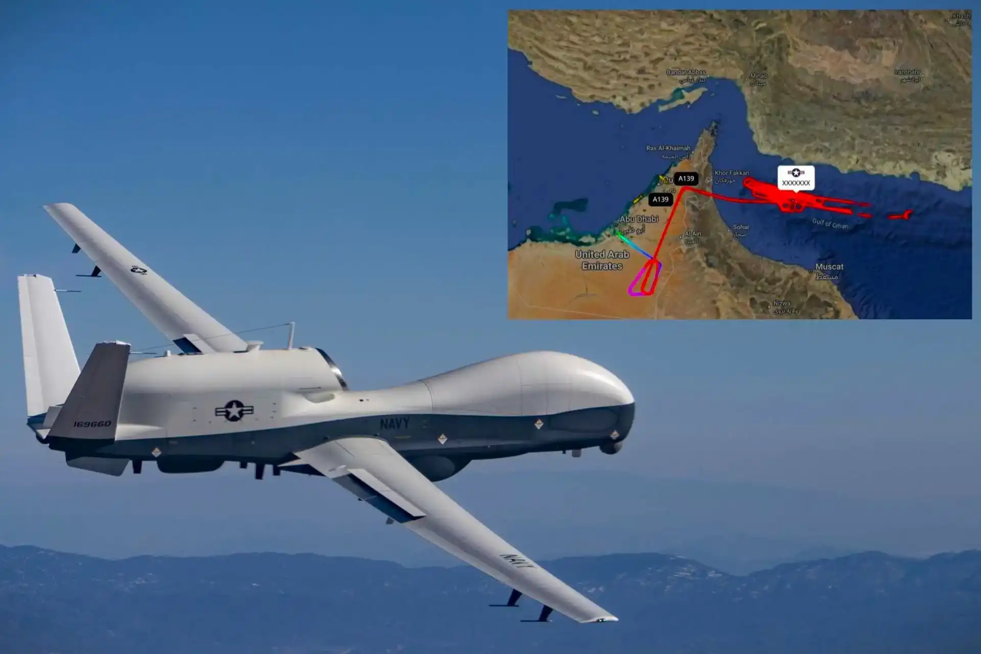
Open-source flight tracking data on 26 February 2026 revealed that a U.S. Navy MQ-4C Triton executed an extended high-altitude surveillance mission over the Gulf of Oman after departing from the United Arab Emirates, underscoring renewed American intelligence collection activity near the Strait of Hormuz. The sortie unfolded amid heightened friction between Washington and Tehran, where maritime security, energy transit, and deterrence signaling have once again converged into a tense strategic equation. Even without official confirmation, the flight profile observed aligns closely with established U.S. Navy high-altitude long-endurance ISR patterns, suggesting deliberate and calibrated operational intent rather than routine airspace transits.
The Gulf of Oman is not an incidental geography. It forms the maritime antechamber to the Strait of Hormuz, the narrow chokepoint through which roughly one-fifth of global oil supply transits daily. Any visible increase in American intelligence, surveillance, and reconnaissance (ISR) activity in this corridor carries operational implications and geopolitical symbolism. Surveillance platforms operating in international airspace near Iran’s southeastern coastline send a message: maritime developments are being watched in detail, persistently, and at scale.
Flight data indicated that the Triton established a prolonged “racetrack” orbit pattern over international waters, maintaining a typical HALE (High-Altitude Long-Endurance) profile above 50,000 feet. From this altitude, the aircraft remains outside many short-range surface-to-air missile threat envelopes while sustaining sensor coverage across vast expanses of sea space. The orbit geometry maximizes dwell time over key shipping lanes and maritime approaches, allowing analysts to build and refine a comprehensive operational picture.
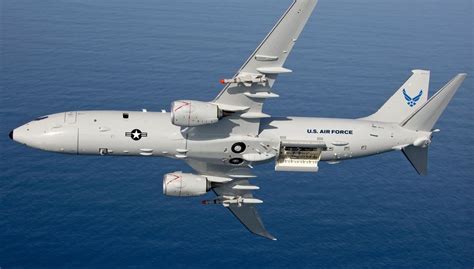
Simultaneously, open-source observers noted the presence of U.S. Navy P-8A Poseidon maritime patrol aircraft operating elsewhere in the Gulf region. This concurrent activity strongly suggests a layered ISR construct rather than an isolated drone sortie. In modern naval operations, persistence and responsiveness are fused: the Triton supplies wide-area cueing and pattern-of-life data, while the P-8A can descend, investigate contacts, conduct anti-submarine or surface surveillance tasks, and generate higher-fidelity identification when required. Together, these platforms create a distributed but integrated maritime domain awareness network stretching from the Gulf of Oman through the Strait of Hormuz and into the Persian Gulf.
The MQ-4C Triton itself is purpose-built for precisely this operational environment. Derived from the RQ-4 Global Hawk, it is optimized for maritime ISR rather than land-centric surveillance. Powered by a single turbofan engine and engineered for endurance exceeding 24 hours, Triton transforms altitude into survivability and persistence into strategic leverage. Unlike tactical drones designed for short-range battlefield roles, the Triton is an ocean-scale sensor platform, capable of surveying thousands of nautical miles in a single mission.
Its principal sensor, the AN/ZPY-3 Multi-Function Active Sensor (MFAS), is an X-band active electronically scanned array radar designed specifically for maritime detection and classification. This radar can conduct wide-area surface searches, generate synthetic aperture radar imagery, and track multiple contacts simultaneously. In practical terms, that means distinguishing between routine commercial shipping and irregular or anomalous vessel behavior. When layered with electro-optical and infrared systems, and potentially signals intelligence payloads, the platform produces a multi-spectral understanding of maritime activity.
Connectivity is equally critical. Through secure line-of-sight and satellite communications links, the Triton feeds data into U.S. and allied command-and-control (C2) networks. Intelligence collected at altitude is not isolated; it is fused into broader joint operational architectures. Commanders at sea and ashore receive a continuously refreshed recognized maritime picture, enabling rapid assessment of emerging patterns or deviations from established baselines.
In periods of tension with Iran, such baseline monitoring becomes strategically consequential. The Islamic Revolutionary Guard Corps Navy (IRGCN) operates fast attack craft, unmanned surface systems, and other asymmetric capabilities designed for swarming tactics and rapid maneuver in confined waters. Detecting changes in deployment density, unusual dispersal of missile-equipped craft, or shifts in coastal defense posture requires sustained observation rather than episodic patrols. Persistent ISR allows analysts to identify subtle deviations before they escalate into overt confrontation.
The observed flight pattern over the Gulf of Oman likely served multiple overlapping objectives. First, it supported maritime security and indications-and-warning (I&W) functions, ensuring that any abnormal naval concentrations or movements could be detected early. Second, it may have contributed to preliminary target development databases, updating geospatial and electronic baselines relevant to contingency planning. Third, it reinforced deterrence by demonstrating visible American monitoring without resorting to kinetic measures.
Deterrence in this context operates less through threat and more through transparency of awareness. When a state signals that it sees and records activity in near real time, it narrows the space for ambiguity. In maritime disputes, ambiguity can be exploited; misidentification, deniable harassment, or gray-zone tactics thrive in informational gaps. A HALE platform orbiting overhead reduces those gaps.
Importantly, the mission unfolded in international airspace, consistent with established norms of freedom of navigation and overflight. This distinction matters diplomatically and legally. Surveillance operations conducted outside territorial boundaries preserve the legitimacy of ISR activity while maintaining operational proximity to areas of concern. The Gulf of Oman provides sufficient standoff distance from Iran’s coastline while still enabling comprehensive sensor coverage of maritime approaches to the Strait of Hormuz.
The broader strategic backdrop includes renewed rhetorical and operational friction between Washington and Tehran. U.S. force posture adjustments in the region, including carrier deployments and bomber task force activities reported elsewhere, form part of a layered signaling architecture. Within that architecture, the MQ-4C Triton represents the non-kinetic spear tip: persistent, unarmed, information-centric.
High-altitude ISR platforms also serve escalation management. By providing decision-makers with granular, near-continuous data, they reduce reliance on worst-case assumptions. In volatile maritime theaters, miscalculation can cascade quickly—from close-quarters maneuvering to exchange of fire within hours. Sustained ISR coverage supports calibrated responses grounded in verified observation rather than conjecture.
Regional basing adds another layer of complexity. Operating from facilities in Gulf partner states underscores Washington’s sustained security relationships while simultaneously intersecting with local political sensitivities. Tehran has previously warned that foreign military installations in neighboring states could be considered legitimate targets in a wider confrontation. Thus, each ISR sortie exists within a lattice of operational necessity and diplomatic calculus.
Yet the mission profile observed on 26 February aligns with longstanding U.S. practice during periods of tension: increase visibility through surveillance rather than immediate force projection. The Triton’s presence signals vigilance, not imminence. Its orbit conveys watchfulness rather than attack preparation.
The Gulf of Oman’s geography amplifies that message. As the outer gateway to the Strait of Hormuz, it is a buffer zone where surveillance can be conducted with operational depth. Monitoring traffic patterns here provides early insight into developments before they converge in the narrower, more congested waters of the Strait itself. That strategic depth is invaluable for crisis anticipation.
Technologically, the mission illustrates the maturation of unmanned maritime ISR doctrine. Where once persistent surveillance required multiple crewed aircraft rotating in shifts, a single Triton can maintain station for an entire day. Endurance becomes a force multiplier, freeing crewed assets like the P-8A for targeted investigations rather than broad-area scanning. The synergy between uncrewed persistence and crewed tactical flexibility represents a defining feature of modern naval reconnaissance.
Ultimately, the MQ-4C Triton sortie over the Gulf of Oman reflects a calibrated expression of strategic maritime signaling toward Iran. It reinforces U.S. commitment to safeguarding sea lines of communication, upholding freedom of navigation, and sustaining regional maritime domain awareness. At the same time, it avoids overt escalation, relying instead on information dominance and persistent presence.
In an era where perception and misperception can shape crisis trajectories as powerfully as missiles or ships, the quiet geometry of a high-altitude orbit carries its own weight. The Triton’s long arcs across the Gulf sky are not dramatic displays of force; they are deliberate reminders that the maritime chessboard is being observed in detail, continuously, and with strategic patience.


