In the realm of aviation, weather can be the ultimate variable, shifting rapidly from clear skies to treacherous conditions within minutes. For pilots, air traffic controllers, and operations teams, anticipating and responding to these shifts is critical. This is where the SPECI (Special Weather Report) proves indispensable—a powerful, unscheduled update that captures sudden and significant meteorological changes which may not wait for the next routine METAR.
SPECI reports are not routine, but when they appear, they demand attention. They act as urgent alerts, flagging conditions that could endanger aircraft during takeoff, en-route phases, or landing. To fully understand the gravity of a SPECI, we must examine its purpose, structure, issuing conditions, and practical decoding.
What Is a SPECI and Why It Matters in Aviation Safety
A SPECI (Special Meteorological Report) is a weather observation released between scheduled METARs when the weather undergoes sudden and substantial changes. Unlike the METAR, which is issued at regular intervals (typically hourly), a SPECI is an immediate response to evolving atmospheric conditions. Its goal is to deliver updated information that could influence critical decisions in aviation operations.
Triggered by strict thresholds set by aviation authorities, a SPECI report serves as a real-time weather warning system. It informs pilots and controllers about the current conditions at an aerodrome, enabling safe and timely rerouting, holding patterns, or even cancellations. The issuing criteria are rooted in flight safety—visibility, wind behavior, cloud cover, temperature deviations, and hazardous phenomena are all potential catalysts for a SPECI.
When Is a SPECI Issued? Trigger Criteria and Examples
A SPECI is issued only under specific circumstances defined by the Federal Aviation Administration (FAA) and the International Civil Aviation Organization (ICAO). These are not discretionary—they are codified thresholds that reflect conditions capable of compromising flight performance or safety.
Key triggers for issuing a SPECI include:
- Visibility falls below 3 statute miles or subsequently rises above this threshold.
- Runway Visual Range (RVR) drops below 2,400 feet or climbs back above it.
- Cloud Ceiling lowers beneath 1,500 feet Above Ground Level (AGL) or cumulonimbus clouds are observed.
- Wind shifts by more than 45 degrees within 10 minutes with a speed of 10 knots or more, or gusts significantly exceed sustained wind speed.
- Present Weather changes rapidly—such as the onset of thunderstorms, heavy precipitation, or the emergence of volcanic ash, dust storms, or funnel clouds.
- Temperature or pressure changes dramatically in a short span, especially during critical phases of flight.
These triggers underscore why a SPECI is not just an advisory—it is an operationally significant report that can redefine flight tactics within minutes.
Anatomy of a SPECI Report: Decoding the Structure
To interpret a SPECI, it’s essential to understand its standardized, globally recognized format, which mirrors the METAR structure. The components provide granular insight into localized weather patterns, critical for both manned and automated decision-making.
1. Report Type, Station, and Timestamp
Every SPECI begins with the keyword SPECI, followed by the ICAO station identifier (e.g., KOKC for Will Rogers World Airport), and the UTC date/time of observation.
2. Report Modifier
The modifier, such as AUTO, indicates whether the report was generated automatically or manually observed. Manual observations may include elements not detectable by automated systems, such as specific lightning types or funnel clouds.
3. Wind Information
This section includes wind direction (in degrees true) and speed (in knots). If gusts are present, the letter G precedes the peak gust value. Variable winds are shown with a range (e.g., 180V250).
4. Visibility
Visibility is reported in statute miles (SM) or meters. It is critical for Visual Flight Rules (VFR) operations and for determining whether Instrument Flight Rules (IFR) approaches are necessary.
5. Runway Visual Range (RVR)
If visibility along a specific runway is significantly reduced, the RVR value is added, indicating how far down the runway a pilot can see during landing or takeoff.
6. Present Weather
This section uses abbreviations to indicate current phenomena, such as:
- RA (rain)
- TS (thunderstorm)
- BR (mist)
- +TSRA (heavy thunderstorms with rain)
These codes help pilots anticipate potential turbulence, low visibility, and electrical activity.
7. Sky Condition
Cloud coverage is given in oktas, representing eighths of sky covered, using terms like:
- FEW (few clouds)
- SCT (scattered)
- BKN (broken)
- OVC (overcast)
Cloud bases are measured in hundreds of feet above ground. For example, OVC010CB indicates a solid overcast of cumulonimbus clouds at 1,000 feet.
8. Temperature and Dew Point
This section presents the current air temperature and dewpoint, both in degrees Celsius. A narrow temperature-dewpoint spread (within 2°C) indicates high humidity and possible fog or mist formation.
9. Altimeter Setting
The pressure reading is provided in inches of mercury (e.g., A2992 = 29.92 inHg). Accurate altimeter settings ensure correct altitude readings, essential during approach and landing.
10. Remarks Section
Often overlooked but critically important, the remarks section includes additional data not displayed elsewhere. For instance:
- TSB25 (thunderstorm began at 25 minutes past the hour)
- TS OHD MOV E (thunderstorm overhead moving east)
- SLP132 (sea-level pressure = 1013.2 hPa)
- WS (wind shear)
These codes deliver granular insight into fast-evolving weather anomalies.
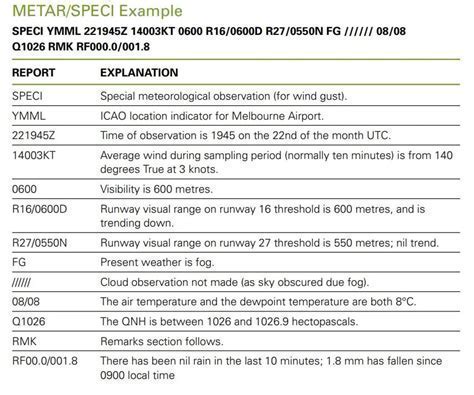
Real-World Example of a SPECI Decoded
Let’s analyze this real-world SPECI:
SPECI KOKC 011955Z AUTO 27015G25KT 180V250 3/4SM R17L/2600FT +TSRA BR OVC010CB 18/16 A2992 RMK AO2 TSB25 TS OHD MOV E SLP132
This indicates:
- Report from KOKC at 1955Z, automated.
- Winds from 270° at 15 knots, gusting to 25 knots, shifting from 180° to 250°.
- Visibility is ¾ statute miles.
- Runway 17L has an RVR of 2,600 feet.
- Heavy thunderstorms and mist present.
- Overcast cumulonimbus at 1,000 feet.
- Temperature 18°C, dewpoint 16°C.
- Altimeter set to 29.92 inHg.
- Thunderstorm began at 1925Z, overhead, moving east.
- Sea-level pressure 1013.2 hPa.
Duration and Validity of SPECI Reports
Unlike METARs, which have a predictable hourly lifecycle, a SPECI remains valid until superseded by a new observation or conditions stabilize. This makes each SPECI a time-sensitive alert. Pilots should cross-reference SPECI with TAF (Terminal Aerodrome Forecast) and the latest METAR to assess short-term and long-term operational risks.
Failing to heed a SPECI could lead to poor situational awareness, particularly when flying in dynamic weather zones. With high-resolution data and immediate relevance, these reports are trusted tools for safe flight planning.
Why SPECI Interpretation Is a Must-Know Skill for Pilots
Correctly interpreting a SPECI is not optional—it’s a professional necessity. Especially for low-time or VFR pilots, understanding the coded language of weather reports enables preemptive decision-making and safer routes. Training and recurrent checks often stress decoding practice using past SPECI samples.
Moreover, flight planning software and Electronic Flight Bags (EFBs) often include SPECI decoding, but these tools should never replace pilot judgment. SPECI enhances situational awareness by focusing attention on what has just changed—the essence of tactical aviation risk management.
Conclusion: SPECI as a Linchpin of Real-Time Flight Risk Management
The role of SPECI in modern aviation cannot be overstated. It is the unsung hero of aviation weather reporting—a real-time pulse on changing conditions. Whether you’re a commercial pilot navigating adverse conditions or an air traffic controller coordinating safe passage through dynamic weather, the SPECI is an invaluable resource that drives informed, proactive decisions. Understanding it fully empowers pilots to adapt to the ever-changing skies, ensuring safety above all else.


