Modern naval warfare depends heavily on advanced electronics, satellite systems, and real-time digital communication. Yet aboard one of the most powerful warships ever built, the USS Abraham Lincoln (CVN-72), navigators still train to guide the massive aircraft carrier across the oceans using nothing more than the sun, stars, and a sextant. In a world dominated by GPS, this centuries-old method—known as celestial navigation—remains a critical capability that ensures the ship can safely maneuver even when all modern systems fail.
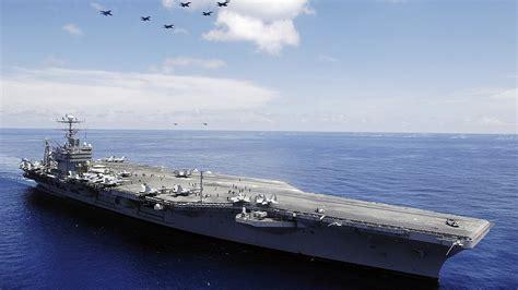
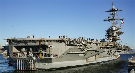
The USS Abraham Lincoln, a Nimitz-class nuclear-powered aircraft carrier, stretches more than 1,090 feet in length and displaces over 100,000 tons when fully loaded. Coordinating the movement of such an enormous vessel through vast stretches of ocean requires precision navigation. Under normal circumstances, the ship relies on satellite-based GPS, radar arrays, and sophisticated digital navigation platforms. However, naval doctrine recognizes a simple reality: electronic systems can fail, be jammed, or be deliberately attacked during conflict.
In high-risk environments where satellite signals might be denied or electronic emissions could reveal a ship’s position, navigators must rely on techniques that cannot be disrupted by cyberwarfare or electronic interference. That is where celestial navigation comes into play—an ancient practice that predates modern navigation by centuries but remains remarkably effective even in the 21st century.
Celestial Navigation: An Ancient Science Guiding Modern Warships
Celestial navigation operates on a straightforward but powerful concept: the positions of celestial bodies relative to Earth are predictable and mathematically charted. By observing the angle between these bodies and the horizon, navigators can determine their precise location on the planet.
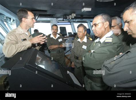
Aboard the USS Abraham Lincoln, trained navigators use specialized instruments such as a sextant, a device designed to measure angles between visible celestial objects and the horizon. The process involves taking measurements—called “sights”—of the sun, moon, planets, or stars at specific moments in time. These observations are then compared with data from nautical almanacs, which list the exact predicted positions of celestial bodies at every moment throughout the year.
When the measured angles differ from the predicted ones, navigators can calculate their location on Earth. This technique effectively turns the sky into a global navigation grid, where each celestial object becomes a reference point for determining position.
Although the concept sounds simple, executing it on a moving warship requires extensive training and careful calculation. The USS Abraham Lincoln’s navigation team must account for variables such as the ship’s speed, ocean motion, atmospheric refraction, and the exact time of the observation.
From Sight to Position: Calculating Location at Sea
Once a celestial observation is taken, navigators translate the measurement into a line of position. This line represents every possible point on Earth where the measured angle could occur relative to that celestial body.
To pinpoint their location more precisely, navigators repeat the process using multiple celestial objects. Each observation produces another line of position. Where these lines intersect on a nautical chart, the ship’s approximate location emerges.
The process unfolds through several careful steps:
- Measuring the angle between a celestial body and the horizon with a sextant
- Recording the exact time of the observation
- Consulting nautical almanacs and celestial tables
- Plotting calculated lines of position on maritime charts
When multiple lines intersect, navigators gain a reliable estimate of the vessel’s position. While the accuracy cannot always match satellite navigation, celestial fixes are often precise enough to safely guide a ship across thousands of miles of ocean.
Another crucial component of navigation aboard the USS Abraham Lincoln is dead reckoning. This method calculates the ship’s estimated position based on its previously known location, speed, heading, and elapsed time. When celestial observations are added to dead-reckoning estimates, navigators can refine the ship’s path with impressive accuracy.
Why the U.S. Navy Still Trains Sailors in Celestial Navigation
Despite the dominance of digital navigation technology, the U.S. Navy continues to emphasize celestial navigation training. The reason is simple: satellites and electronics are vulnerable.
GPS signals can be jammed or spoofed by adversaries. Radar emissions can reveal a ship’s location to hostile forces. Even onboard electronics can fail due to mechanical issues, cyberattacks, or combat damage. In such scenarios, celestial navigation offers a fully independent navigation method that relies only on natural celestial patterns.
Because the positions of stars and planets are governed by physics rather than technology, they cannot be hacked, blocked, or disabled. This makes celestial navigation one of the most resilient navigation techniques ever developed.
Naval strategists often view it as the ultimate backup system—an ancient technology that guarantees a modern warship can still find its way home even if every digital tool goes dark.
The Strategic Importance of the USS Abraham Lincoln
The USS Abraham Lincoln is not just another warship. As a nuclear-powered supercarrier, it represents one of the most powerful mobile military platforms in existence. The vessel can carry around 90 aircraft, including advanced fighter jets, surveillance aircraft, and helicopters. With its nuclear reactors providing propulsion, the ship can operate for decades without refueling, allowing it to remain deployed for extended missions across the globe.
Because of its size and strategic value, ensuring that the carrier can safely navigate the world’s oceans under any circumstances is critical. Losing access to satellite navigation during operations would not stop the ship from moving—it would simply require the crew to switch to more traditional techniques.
This resilience reflects the philosophy behind naval training: technology should enhance human skill, not replace it. By maintaining proficiency in celestial navigation, the sailors aboard the USS Abraham Lincoln ensure that the carrier remains operational even in the most challenging electronic warfare environments.
When the Stars Become the Ultimate Navigation System
On a quiet night in the open ocean, far from coastal lights, the sky becomes an enormous map. Constellations drift slowly overhead while the horizon cuts a clean line across the dark sea. For a trained navigator, those stars are not just beautiful—they are precise navigational markers that reveal the ship’s position on Earth.
In moments when satellites fall silent and radar screens go dark, the USS Abraham Lincoln can still chart its course by looking upward. The same celestial bodies that guided ancient mariners across unknown oceans continue to guide one of the world’s most advanced warships today.
The result is a remarkable blend of ancient science and modern naval engineering. Even in an era of satellites and digital warfare, the timeless patterns of the heavens remain a dependable compass for those who know how to read them.


