Weather drones, formally known as weather-sensing unmanned aerial vehicles (UAVs), are rapidly redefining how we observe, analyze, and predict atmospheric conditions. By carrying advanced sensor payloads into the mid and lower atmosphere, these intelligent platforms offer a level of flexibility, precision, and accessibility that traditional systems struggle to match. As the demand for high-resolution meteorological data intensifies, weather drones stand at the forefront of a new observational era—one where data is gathered not just broadly, but strategically and dynamically.
The Evolution of Weather Drone Innovation
The concept of using unmanned aircraft for atmospheric observation dates back to 1970, when researchers successfully deployed a small radio-controlled aircraft as a meteorological measurement platform. This early experiment, supported by institutions such as NASA and the Air Force Cambridge Research Laboratory, proved that compact, controllable aircraft could deliver reliable environmental data.
Over the following decades, innovation accelerated. A pivotal milestone emerged in 1993 with the development of the Aerosonde, a fixed-wing UAV engineered to collect weather data in remote and otherwise inaccessible regions. This project, backed by the U.S. Office of Naval Research, demonstrated the feasibility of long-duration atmospheric monitoring missions. By the late 1990s, the technology had matured enough for broader operational deployment, eventually evolving into a dual-purpose system supporting both meteorological research and military intelligence.
By the early 21st century, weather drones had transitioned from experimental prototypes to specialized scientific instruments. Their ability to access hazardous or remote environments—such as polar regions, oceans, and storm systems—positioned them as indispensable tools in modern atmospheric science.
How Weather Drones Collect Atmospheric Data
Weather drones are engineered to capture a wide spectrum of thermodynamic and kinematic variables. Equipped with miniaturized sensors, they measure:
- Temperature gradients
- Humidity levels
- Atmospheric pressure
- Wind speed and direction
- Moisture content and turbulence
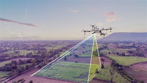
Unlike traditional weather balloons, which drift passively and cannot be retrieved, drones offer controlled, repeatable flight paths. This allows researchers to conduct targeted sampling missions, revisiting specific locations or altitude ranges with precision.
A defining advantage lies in their ability to perform vertical profiling of the atmosphere. By ascending and descending through the boundary layer—typically up to 6 kilometers—weather drones generate high-resolution data layers critical for understanding mesoscale phenomena such as thunderstorms, fog formation, and temperature inversions.
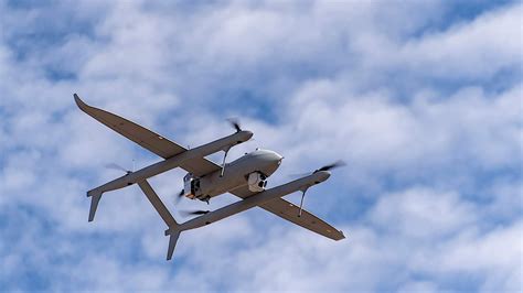
Fixed-Wing vs. Rotary-Wing Weather Drones
The design of a weather drone significantly influences its operational capabilities. Two primary configurations dominate the field: fixed-wing and rotary-wing systems.
Fixed-wing drones excel in endurance and range. Their aerodynamic efficiency enables long-duration flights, making them ideal for surveying large geographic areas or tracking evolving weather systems. These drones are particularly effective in missions requiring continuous data collection over extended distances.
In contrast, rotary-wing drones—such as quadcopters—offer unmatched maneuverability and vertical control. They can hover, ascend vertically, and operate in confined spaces, making them highly suitable for localized atmospheric profiling. Their ability to remain stationary in the air allows for precise, time-resolved measurements at specific altitudes.
The growing popularity of rotary-wing systems reflects a broader shift toward high-frequency, localized observations, especially in research focused on the atmospheric boundary layer.
Closing the Data Gap in the Lower Atmosphere
One of the most compelling arguments for weather drone adoption is their ability to address the longstanding “boundary layer data gap.” Traditional observation systems, such as satellites and weather balloons, often lack the resolution or control needed to accurately capture conditions in the lowest layers of the atmosphere.
This gap has significant implications. The boundary layer plays a crucial role in weather formation, pollutant dispersion, and energy exchange processes. Inadequate data from this region can lead to inaccuracies in numerical weather prediction models.
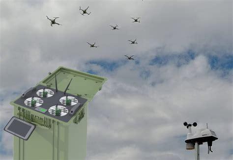
Recognizing this challenge, initiatives like the 3D Mesonet—developed by the University of Oklahoma’s Center for Autonomous Sensing and Sampling—have pioneered networks of drone-launching stations. These systems deploy drones at regular intervals, generating continuous, three-dimensional datasets that dramatically enhance forecasting accuracy.
Weather Drones in Extreme Conditions
The true potential of weather drones becomes evident in their ability to operate in extreme and hazardous environments. In 2022, the National Oceanic and Atmospheric Administration (NOAA) achieved a groundbreaking milestone by deploying the Area-I Altius-600 drone directly into Hurricane Ian.
Flying at altitudes between 900 meters and 1.3 kilometers, the drone penetrated the hurricane’s eye and eyewall, collecting real-time data on temperature, pressure, and moisture. Such missions were previously impossible or highly risky using manned aircraft.
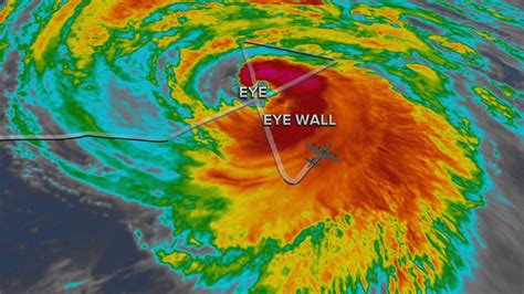
This capability not only enhances scientific understanding of severe weather systems but also contributes to improved early warning systems, potentially saving lives and reducing economic losses.
Commercial Development and Industry Players
Despite their promise, the commercial market for weather drones remains relatively niche. A limited number of companies have emerged as pioneers in this domain. Among them, Meteomatics AG, a Swiss firm, has gained recognition for its Meteodrone systems, which integrate advanced sensors with robust flight capabilities.
Another entrant, the British company Menapia, introduced its MetSprite platform, expanding the range of available solutions. Recent innovations have also introduced ultralight rotary-wing drones capable of being carried aloft by weather balloons before performing controlled descents—an ingenious hybrid approach that combines the strengths of both technologies.
These developments signal a gradual shift toward scalable, commercially viable drone-based meteorology, though widespread adoption remains constrained by regulatory and technical challenges.
Advantages That Redefine Meteorological Observation
Weather drones offer a suite of advantages that make them uniquely suited for modern atmospheric research:
- High spatial and temporal resolution: Drones can collect data at precise locations and intervals, enabling granular analysis.
- Operational flexibility: They can be deployed rapidly in response to emerging weather events.
- Cost efficiency: Compared to manned aircraft, drones significantly reduce operational expenses.
- Safety: They eliminate the need for human pilots in dangerous environments.
These benefits collectively position weather drones as a transformative tool in both research and applied meteorology.
Technical and Regulatory Challenges
While the advantages are compelling, several obstacles must be addressed before weather drones can achieve full operational integration into national meteorological systems.
One of the most significant barriers is the lack of standardized airspace regulations for UAV operations. Integrating drones into controlled airspace requires careful coordination to ensure aviation safety and compliance.
Additionally, technical challenges persist. Issues such as in-flight icing, wind resistance, and limited automation can compromise mission reliability. Icing, in particular, has historically led to the loss of multiple UAVs. However, innovations such as rotor blade heating systems—first introduced by Meteomatics—have begun to mitigate these risks.
Automation also remains an area of active development. Fully autonomous systems capable of managing flight planning, refueling, and maintenance are essential for scaling drone networks to operational levels.
The Future of Weather Drones in Operational Meteorology
The trajectory of weather drone technology points toward increasing integration with national meteorological and hydrological services (NMHS). Although regulatory hurdles currently limit their widespread use, ongoing collaboration between government agencies, research institutions, and private companies is steadily paving the way for broader adoption.
Future systems are likely to feature enhanced autonomy, longer flight endurance, and more sophisticated sensor arrays. Combined with advances in artificial intelligence and data analytics, weather drones will not only collect data but also contribute to real-time decision-making processes.
The vision is clear: a globally interconnected network of drones continuously sampling the atmosphere, feeding data into predictive models, and enabling hyper-local, highly accurate weather forecasts.
Conclusion: A New Paradigm in Atmospheric Science
Weather drones represent a profound shift in how humanity observes the atmosphere. By bridging critical data gaps, enabling exploration of extreme environments, and delivering unprecedented levels of detail, they are redefining the boundaries of meteorological science.
As technological and regulatory challenges are progressively resolved, the role of weather drones will expand from experimental tools to operational essentials. In this evolving landscape, those who harness the full potential of drone-based observation will shape the future of weather forecasting, climate research, and environmental monitoring.
The sky, once a barrier to understanding, is quickly becoming a data-rich frontier—mapped, measured, and mastered by weather drones.

")


