The sky above the United States looks infinite from the ground, a blue cathedral of open space. In reality, it is meticulously divided, monitored, and choreographed. Commercial airliners cruise in orderly lanes, private pilots navigate prescribed corridors, and high-performance military aircraft slice through carefully defined sectors at supersonic speed. The margin for error is vanishingly small. Yet the system works with extraordinary reliability. The reason lies in a deeply integrated architecture of airspace design, advanced avionics, interagency cooperation, and battlefield-grade data networks that together explain how the US Air Force avoids mid-air collisions in both peace and war.
The scale alone is staggering. The United States operates the world’s largest and most technologically advanced air force, flying everything from stealth fighters and heavy bombers to tankers, drones, and helicopters. These aircraft must often share civil airspace with tens of thousands of daily commercial flights. Safety is not an afterthought; it is engineered into the system at every level. From altitude stratification to AI-enhanced sensor fusion, collision avoidance is treated as a layered defense, where redundancy is strength and visibility is non-negotiable.
The foundation begins not in the cockpit, but in the structure of the sky itself. For decades, the Federal Aviation Administration (FAA) and the Department of Defense (DOD) have cooperated to partition American airspace into vertical and horizontal blocks of responsibility. This strategic segmentation ensures that high-speed military operations remain separated from civilian traffic, even when both share overlapping geographic regions.
Airspace Deconfliction: The Architecture Behind Military Flight Safety
The simplest and most enduring method of preventing mid-air collisions is altitude separation. Civilian airliners typically cruise in well-defined flight levels, while military aircraft operating under specific mission profiles are assigned different altitude blocks. This vertical deconfliction creates invisible layers of traffic, each with defined floors and ceilings, reducing the risk of unintended convergence.
Beyond altitude management, the Air Force relies heavily on designated training corridors known as Military Training Routes (MTRs). These routes allow jets to fly at extremely high speeds, often at low altitude, in controlled environments. MTRs are charted and published, and they exist precisely so that military pilots can train realistically without surprising civilian traffic. Some routes are instrument-rated, enabling operations in low visibility, while others require visual meteorological conditions. Each route is a controlled experiment in disciplined speed.
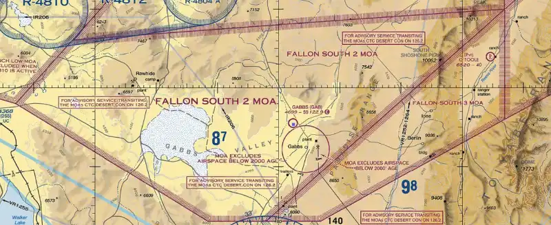
Complementing these corridors are Military Operations Areas (MOAs). These airspace segments are designed for non-hazardous military training such as air combat maneuvering, intercept practice, and tactical formations. Civil aircraft are not outright banned from active MOAs, but entry is discouraged and carefully coordinated. Air traffic controllers maintain situational awareness to ensure safe separation when transit becomes necessary.
This structured airspace design creates predictable boundaries. Predictability, in aviation, is the antidote to chaos.
ADS-B and Transponder Visibility: Making Even Stealth Aircraft Seen
Technology transforms structure into real-time safety. One of the most critical tools in modern airspace management is Automatic Dependent Surveillance-Broadcast (ADS-B). This system broadcasts an aircraft’s precise GPS position, altitude, velocity, and identification to both air traffic controllers and nearby aircraft. It replaces older radar-only tracking with satellite-based precision.
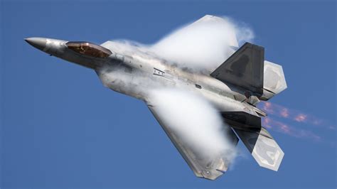
Even stealth fighters operate with ADS-B Out when flying in civilian airspace. That detail surprises many observers. Stealth is about combat survivability, not invisibility to domestic air traffic control. When transitioning from base to training range, aircraft such as the F-35 Lightning II or F-22 Raptor broadcast their data just like commercial jets. This transparency ensures seamless integration with civil aviation networks.
Most military aircraft also carry a version of the Traffic Alert and Collision Avoidance System (TCAS). TCAS monitors nearby transponders and issues audible resolution advisories when a conflict is detected. If two aircraft equipped with TCAS II approach each other too closely, their systems coordinate automatically. One aircraft will receive a “Climb” instruction while the other hears “Descend,” preventing mirrored reactions that could worsen the situation.
Collision avoidance here is not guesswork. It is algorithmic diplomacy between machines.
Auto GCAS and Next-Generation Automated Deconfliction
In fighter cockpits, collision avoidance has evolved beyond warning systems into automated intervention. The Automatic Ground Collision Avoidance System (Auto GCAS) was initially designed to prevent Controlled Flight Into Terrain, a leading cause of fighter losses. The system continuously calculates the aircraft’s trajectory against digital terrain databases. If a crash becomes imminent and the pilot does not respond, the computer takes over and pulls the jet to safety.
What began as ground-collision protection has proven valuable in air-to-air scenarios as well. Automated logic can assess closing speeds and projected flight paths far faster than human reaction time. In aircraft like the F-16 and F-35, this digital guardian provides an additional safety net.
The Air Force is also testing Collision Avoidance Manual Deconfliction (CAMD) technology. This system is designed to enhance integration between military fighters and civilian traffic by predicting potential conflicts earlier in the engagement envelope. Instead of seconds of warning, pilots may gain minutes. In high-speed aviation, minutes feel like borrowed time from the universe.
AI-Enhanced Situational Awareness and Sensor Fusion
Artificial intelligence is now entering the equation with increasing sophistication. AI-driven algorithms analyze real-time trajectories of both military and civil aircraft, predicting near-miss scenarios before they unfold. These systems function like probability engines, scanning thousands of possible motion vectors to identify convergence patterns invisible to the naked eye.
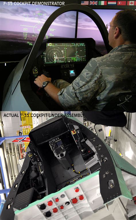
The F-35’s Distributed Aperture System (DAS) exemplifies this fusion approach. Six infrared cameras mounted around the aircraft create a seamless 360-degree view. Combined with radar inputs and ADS-B data, the system builds a comprehensive digital model of the surrounding airspace. The pilot’s Helmet-Mounted Display System projects this information directly onto the visor, eliminating the need for a traditional heads-up display.
Pilots can effectively “see” through the aircraft’s structure, observing threats below or behind them. The fusion of data sources reduces ambiguity and enhances spatial awareness. In aviation, clarity is survival.
De-Stealthing Protocols: Luneburg Lenses and Formation Leadership
Stealth aircraft present a unique challenge in civil transit. Their low-observable design intentionally reduces radar returns. To prevent invisibility from becoming a liability, the Air Force uses physical hardware to temporarily amplify radar signatures.
One solution is the Luneburg Lens, a radar-reflective device mounted externally on stealth jets during peacetime transit. This lens reflects radar waves directly back to the source, dramatically increasing visibility. On an air traffic controller’s display, a small stealth fighter can appear as prominent as a widebody airliner.
Additionally, stealth formations often fly with a non-stealth “lead” aircraft equipped with a powerful transponder. Controllers assign a protective airspace block to the entire formation based on that lead aircraft’s signal. High-intensity navigation lights and active transponder codes further ensure clear identification.
Before combat missions, these lenses are removed. Stealth returns to its intended purpose. In domestic skies, transparency prevails.
Link 16 and the Common Tactical Picture in Combat Airspace
Collision avoidance becomes exponentially more complex in active battle zones. In these compressed theaters, dozens or even hundreds of aircraft may operate simultaneously at varying altitudes and speeds. Weapons deployment adds additional layers of hazard.
The backbone of deconfliction in combat is Link 16, a secure tactical data link network. Every participating aircraft broadcasts its precise three-dimensional position, heading, and fuel state. This information feeds into a shared Common Tactical Picture (CTP) displayed across cockpits and command centers.
Unlike civilian air traffic control, which prioritizes separation and efficiency, combat controllers prioritize mission flow while maintaining spatial order. The Air Operations Center issues an Airspace Control Order (ACO) that assigns altitude bands and mission sectors to different aircraft types. Close air support platforms such as the A-10 may operate below 10,000 feet, while air superiority fighters patrol far above 30,000 feet.
The principle mirrors civilian stratification, but with battlefield urgency and encrypted precision.
AWACS and the “Eye in the Sky” Command Layer
Overseeing both routine operations and combat scenarios is airborne command and control. The iconic Boeing E-3 Sentry AWACS, instantly recognizable by its rotating radar dome, functions as an airborne control tower. From high altitude, it scans vast areas of airspace and coordinates aircraft movements.
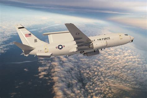
For carrier operations, the US Navy employs the Grumman E-2 Hawkeye, a turboprop platform capable of launching from and landing on aircraft carriers. The forthcoming Boeing E-7 Wedgetail, equipped with a fixed Multirole Electronically Scanned Array radar, represents the next evolution. Its advanced radar system provides continuous coverage without mechanical rotation, increasing reliability and detection precision.
These aircraft act as force multipliers. For older fighters or drones lacking advanced data links, AWACS crews provide verbal vectors and real-time corrections, preventing convergence with high-speed strike packages. The metaphor of an “eye in the sky” is not poetic exaggeration. It is operational reality.
Helicopters, Low-Altitude Flight, and Civil Integration
The United States military operates the largest fleet of helicopters in the world. Low-altitude rotary-wing flight presents unique collision risks due to terrain masking and visual clutter. Similar separation principles apply: designated training zones, altitude coordination, and active transponder broadcasting.
Helicopters flying in civil corridors maintain communication with local air traffic control and use visible lighting configurations during transit. When conducting tactical low-level maneuvers, operations are confined to restricted or coordinated airspace. The objective remains constant: isolate risk within predictable boundaries.
A Multi-Layered System Designed for Redundancy
The brilliance of the Air Force’s collision avoidance strategy lies not in any single technology, but in layered integration. Airspace segmentation creates macro-level order. ADS-B and TCAS ensure aircraft-to-aircraft awareness. Automated systems like Auto GCAS add a digital safety net. AI forecasting expands reaction windows. Physical hardware like Luneburg lenses compensates for stealth. Link 16 builds shared awareness in combat. AWACS provides command oversight from above.
Each layer assumes that another might fail. Redundancy is not inefficiency; it is resilience.
The American sky is not empty. It is orchestrated. Every altitude assignment, every transponder code, every data packet transmitted through Link 16 contributes to a synchronized ballet of metal and mathematics. Mid-air collisions are avoided not by luck, but by architecture, discipline, and relentless technological evolution.
Aviation remains unforgiving. Physics does not negotiate. Yet through a combination of structured airspace, intelligent avionics, and cooperative doctrine between civil and military authorities, the US Air Force has built one of the most comprehensive airspace safety systems ever conceived. It is a system where invisibility can be reversed, where machines negotiate climb and descent in milliseconds, and where the sky itself becomes an engineered environment rather than a void.
In that invisible framework lies the true answer to how the US Air Force avoids mid-air collisions: it treats safety not as a procedure, but as a continuously evolving ecosystem of design, data, and disciplined execution.


