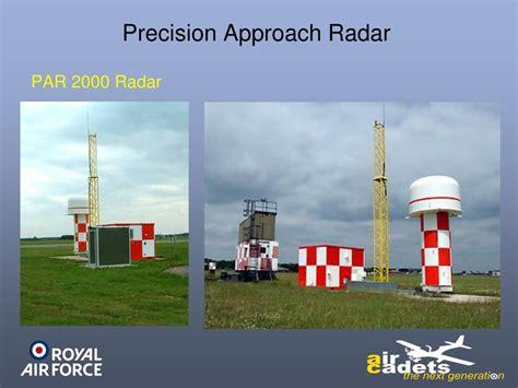
Understanding Precision Approach Radar (PAR)
Precision Approach Radar (PAR) is a key radar system used in aviation. It helps determine an aircraft’s position during its final approach. This includes both lateral and vertical deviations from the standard approach path, as well as the distance to touchdown.
PARs are essential tools for air traffic controllers. They provide guidance to pilots during the critical final stages of landing using radio signals. Unlike Instrument Landing Systems (ILS), PAR does not require any special equipment onboard the aircraft. However, since ILS has become a standard feature on most planes, the advantage of PAR has decreased over time.
Despite this, PAR increases the workload for controllers and can lead to frequency congestion. Therefore, when a controller is managing a precision approach, they should focus solely on that task. This requirement limits the capacity of air traffic services (ATS), leading to a decline in PAR use in civil aviation. However, PAR remains valuable for military operations, as it is less detectable by missiles compared to ILS.
The operation of PAR relies on primary radar principles. The radar antenna emits pulses that reflect off aircraft, allowing controllers to calculate their distance and direction. PAR stands out because it provides greater accuracy than typical surveillance radars. This higher precision is achieved through a higher carrier frequency, around 10 GHz, which allows for a narrower beam.
PAR can determine an aircraft’s position in three dimensions: distance from touchdown, lateral position relative to the runway centerline, and altitude relative to the glide path. Older systems utilize a second vertical antenna for measuring elevation, while newer options employ electronic beam steering with fewer moving parts.
PAR also has a faster update rate. While terminal radars typically rotate at 10-12 revolutions per minute, PAR sweeps a narrower sector of about 20 degrees. This allows for more frequent updates on the aircraft’s position.
The approach controller receives a 3D representation of the aircraft’s location, comprising both a planar view and a vertical cut view. This information helps the controller compare the aircraft’s actual position and altitude against required parameters, allowing for timely feedback to the flight crew.
Controllers must have a specific PAR endorsement to their Approach Control Surveillance (APS) rating to operate this system. During a precision approach, the controller continuously communicates with the pilot, providing information on the aircraft’s position relative to the runway centerline, distance from touchdown, heading instructions, and altitude adjustments.
Here’s an example dialogue between a pilot and an air traffic controller:
ATC: FASTAIR 345, THIS WILL BE A PRECISION RADAR APPROACH RUNWAY 27, OBSTACLE CLEARANCE ALTITUDE 400 FEET, POSITION 6 MILES EAST OF GEORGETOWN, TURN RIGHT HEADING 260, DESCEND TO 2,500 FEET QNH 1014
Pilot: PRECISION APPROACH RUNWAY 27, HEADING 260 DESCENDING TO 2,500 FEET QNH 1014 FASTAIR 345
ATC: FASTAIR 345 CLOSING FROM THE RIGHT, TURN RIGHT HEADING 270
Pilot: RIGHT HEADING 270 FASTAIR 345
ATC: FASTAIR 345 ON TRACK, APPROACHING GLIDE PATH, HEADING IS GOOD
Pilot: FASTAIR 345
ATC: FASTAIR 345 REPORT RUNWAY IN SIGHT
Pilot: FASTAIR 345
ATC: FASTAIR 345 DO NOT ACKNOWLEDGE FURTHER TRANSMISSIONS, ON TRACK APPROACHING GLIDE PATH… CHECK YOUR MINIMA… COMMENCE DESCENT NOW AT 500 FEET PER MINUTE… I SAY AGAIN 500 FEET PER MINUTE… CHECK GEAR DOWN AND LOCKED… ON GLIDE PATH 5 MILES FROM TOUCHDOWN… SLIGHTLY LEFT OF TRACK, TURN RIGHT 5 DEGREES NEW HEADING 275, I SAY AGAIN 275… 4 MILES FROM TOUCHDOWN SLIGHTLY BELOW GLIDE PATH… 100 FEET TOO LOW ADJUST RATE OF DESCENT… STILL 50 FEET TOO LOW, TURN LEFT 3 DEGREES HEADING 272 ON TRACK 3 MILES FROM TOUCHDOWN…
Pilot: FASTAIR 345 RUNWAY IN SIGHT
ATC: COMING BACK TO THE GLIDE PATH… ON GLIDE PATH 2½ MILES FROM TOUCHDOWN RESUME NORMAL RATE OF DESCENT… FASTAIR 345 CLEARED TO LAND… ON GLIDE PATH… HEADING 272 IS GOOD SLIGHTLY ABOVE GLIDE PATH… 2 MILES FROM TOUCHDOWN… COMING BACK TO THE GLIDE PATH… ON GLIDE PATH 1¾ MILES FROM TOUCHDOWN… TURN LEFT 2 DEGREES NEW HEADING 270… 1½ MILES FROM TOUCHDOWN… ON GLIDE PATH 1¼ MILES FROM TOUCHDOWN RATE OF DESCENT IS GOOD ON GLIDE PATH 1 MILE FROM TOUCHDOWN… ¾ OF A MILE FROM TOUCHDOWN ON GLIDE PATH… ½ MILE FROM TOUCHDOWN ON GLIDE PATH… ¼ MILE FROM TOUCHDOWN APPROACH COMPLETED AFTER LANDING CONTACT TOWER ON 118.7
: A Pilot’s Guide to Radar-Guided Landings")
")


")
 Approach: Enhancing Aviation Precision and Safety")


